

Surf Forecasts:

How big are the waves at Aitape today (03 Aug):
- Morning surf: Morning surf (03 Aug, local time) - 2ft (0.6m), 14s period with NE swell.
- Afternoon surf: Afternoon surf (03 Aug, local time) - 2.5ft (0.7m), 14s period with NE swell.
- Evening surf: Evening surf (03 Aug, local time) - 2ft (0.6m), 16s period with NNE swell.
The current surf forecast for Aitape at 9AM is: 0.6m 14s primary swell from a Northeast direction and 0.2m 16s secondary swell from a East-northeast direction (forecast issued at 03:00am August 03). An open ocean swell of 0.7m 7s is not directed at the surf break. The wind direction is predicted to be cross-offshore.
| Time (+10) & Date | Wave Height | Wave Period |
|---|---|---|
| Morning (03 Aug) | 2ft (0.6m) | 14s |
| Afternoon (03 Aug) | 2.5ft (0.7m) | 14s |
| Evening (03 Aug) | 2ft (0.6m) | 16s |
Table - waves today at Aitape. (Swell directed towards the surf break)
Short Range ForecastModerate rain (total 19mm), heaviest on Mon night. Warm (max 29°C on Mon morning, min 25°C on Mon night). Wind will be generally light. | ||||||||||||||||||||||||
Monday 3 | Tuesday 4 | Wednesday 5 | ||||||||||||||||||||||
1 AM | 4 AM | 7 AM | 10 AM | 1 PM | 4 PM | 7 PM | 10 PM | 1 AM | 4 AM | 7 AM | 10 AM | 1 PM | 4 PM | 7 PM | 10 PM | 1 AM | 4 AM | 7 AM | 10 AM | 1 PM | 4 PM | 7 PM | 10 PM | |
Swell Height Map |  | 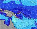 | 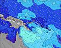 | 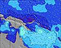 | 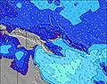 | 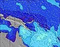 | 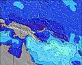 | 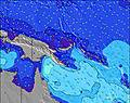 | 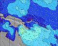 | |||||||||||||||
Wave Height (m) Direction Period (s) | NE 12 | NE 15 | NE 13 | NE 14 | NE 14 | NE 14 | NE 13 | NNE 16 | NE 15 | NE 14 | NE 14 | NE 14 | NE 14 | NE 13 | NE 13 | NE 13 | NNE 15 | NNE 15 | NNE 14 | NNE 14 | NNE 13 | NNE 13 | NNE 13 | N 15 |
Wave Graph | ||||||||||||||||||||||||
69 | 77 | 144 | 149 | 181 | 179 | 108 | 162 | 109 | 214 | 211 | 194 | 186 | 180 | 140 | 138 | 142 | 144 | 183 | 178 | 204 | 154 | 198 | 110 | |
Wind (km/h) | ||||||||||||||||||||||||
Wind State on-shore cross-onshore cross-shore cross-offshore off-shore glassy | cross-off | cross | cross-off | cross-off | cross | cross-on | cross-on | glassy | off | glassy | glassy | glassy | glassy | on | glassy | glassy | glassy | glassy | glassy | cross-on | cross-on | cross-on | glassy | glassy |
High Tide | 10:40PM1.14m | 10:10AM0.97m | 11:02PM1.15m | 11:21AM0.93m | 11:27PM1.16m | 12:43PM0.90m | ||||||||||||||||||
Low Tide | 4:52AM0.65m | 4:20PM0.48m | 5:40AM0.55m | 4:55PM0.59m | 6:31AM0.45m | 5:33PM0.70m | ||||||||||||||||||
— | 6:37 | — | — | — | — | — | — | — | 6:37 | — | — | — | — | — | — | — | 6:37 | — | — | — | — | — | — | |
— | — | — | — | — | 6:36 | — | — | — | — | — | — | — | 6:36 | — | — | — | — | — | — | — | 6:36 | — | — | |
mm | — | 1 | 1 | — | — | — | — | — | — | 1 | 4 | 2 | 1 | 1 | — | — | — | 2 | 2 | 2 | 1 | 1 | — | — |
Temp °C | 26 | 26 | 26 | 28 | 29 | 29 | 27 | 26 | 26 | 25 | 25 | 27 | 28 | 28 | 27 | 26 | 25 | 25 | 26 | 27 | 28 | 28 | 27 | 26 |
Feels °C | 30 | 30 | 29 | 30 | 31 | 32 | 31 | 31 | 31 | 30 | 30 | 32 | 33 | 32 | 32 | 31 | 29 | 29 | 30 | 31 | 32 | 32 | 32 | 30 |
Swell 1 Height (m) Direction Period (s) | E 7 | E 7 | NE 13 | NE 14 | NE 14 | E 7 | E 8 | E 8 | E 8 | E 8 | E 8 | E 8 | E 8 | E 8 | E 8 | E 8 | E 8 | E 8 | NNE 14 | NNE 14 | NNE 13 | NNE 13 | NNE 13 | E 7 |
39 | 39 | 144 | 149 | 181 | 65 | 72 | 71 | 76 | 86 | 84 | 65 | 63 | 65 | 66 | 66 | 66 | 47 | 183 | 178 | 204 | 154 | 198 | 37 | |
Swell 2 Height (m) Direction Period (s) | NE 12 | NE 12 | E 7 | ENE 16 | ENE 15 | NE 14 | NE 13 | NNE 16 | NE 15 | NE 14 | NE 14 | NE 14 | NE 14 | NE 13 | NE 13 | NE 13 | NNE 15 | NNE 15 | E 8 | E 8 | E 8 | E 8 | E 7 | NNE 12 |
69 | 77 | 38 | 24 | 22 | 179 | 108 | 162 | 109 | 214 | 211 | 194 | 186 | 180 | 140 | 138 | 142 | 144 | 46 | 44 | 42 | 41 | 39 | 103 | |
Swell 3 Height (m) Direction Period (s) | NE 14 | NE 15 | ENE 16 | N 9 | NNE 18 | ENE 15 | NE 16 | NE 12 | NE 13 | ENE 15 | ENE 15 | ENE 14 | ENE 14 | ENE 14 | NE 16 | NE 16 | NE 12 | NE 12 | ENE 13 | ENE 13 | ENE 13 | NNE 16 | ENE 13 | N 15 |
65 | 77 | 25 | 6 | 32 | 42 | 63 | 51 | 82 | 42 | 42 | 41 | 40 | 38 | 67 | 67 | 50 | 73 | 35 | 35 | 34 | 49 | 33 | 110 | |
Wind waves Height (m) Direction Period (s) | — | — | — | E 7 | E 7 | — | — | — | — | — | — | — | — | — | — | — | — | — | — | — | — | — | — | — |
— | — | — | 52 | 68 | — | — | — | — | — | — | — | — | — | — | — | — | — | — | — | — | — | — | — | |
Nearest Offshore or Glassy | ||||||||||||||||||||||||
Distance (km) | 0 | 125 | 0 | 0 | 931 | 931 | 101 | 0 | 0 | 0 | 0 | 0 | 0 | 101 | 0 | 0 | 0 | 0 | 0 | 31 | 101 | 101 | 0 | 0 |
Best forecast wave conditions in Sandaun | ||||||||||||||||||||||||
Best forecast wave conditions in Papua New Guinea | ||||||||||||||||||||||||
Header Global | ||||||||||||||||||||||||
- Map Icons:
 Break
Break Live Wave Height (m)
 Live Wind Speed (km/h)
 Surf Rating (10 Max)
 Ocean Swells (m)
- Wind Speed (km/h)
Latest Updates


FREE! Surf-Forecast.com widget for your website
The surf report / weather widget below is available to embed on third party websites free of charge and provides a summary of our Aitape surf forecast. Simply grab the html code snippet that we provide and paste it into your own site. You can choose your preferred language and metric/imperial units for the surf forecast feed to suit users of your site. Click here to get the code.
 Nearest