
South End Surf Guide
South End in South Carolina is an exposed beach break that only works once in a while with no particular seasonal pattern. Works best in offshore winds from the northwest. Tends to receive a mix of groundswells and windswells and the ideal swell direction is from the southeast. Waves at the beach tend to peel to the right. Relatively few surfers here, even on good days. Beware of rips and sharks.
South End Spot Info
| Type: | Rating: | Reliability: | Todays Sea Temp*: |
|---|---|---|---|
| inconsistent | 25.0°C*ocean temperature recorded from satellite |
Surfing South End:
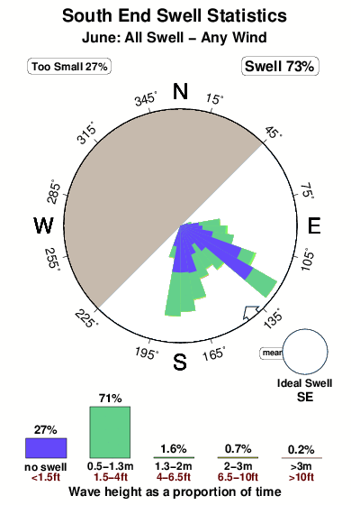
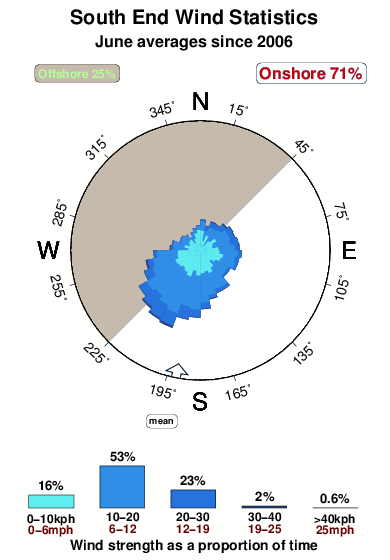
The best conditions reported for surf at South End occur when a Southeast swell combines with an offshore wind direction from the Northwest.
What's the best time of year to surf South End (for consistent clean waves)?
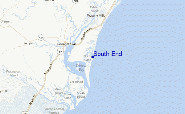
Explore South End Location Map
Interactive South End surf break location map. View information about nearby surf breaks, their wave consistency and rating compared to other spots in the region. Current swell conditions from local buoys are shown along with live wind speed and direction from nearby weather stations. Click icons on the map for more detail. The closest passenger airport to South End is Myrtle Beach International Airport (MYR) in USA, 46 km (29 miles) away (directly). The second nearest airport to South End is Charleston Afb International Airport (CHS), also in USA, 94 km (58 miles) away.
- Map Icons:
 Break
Break Live Wave Height (m)
 Live Wind Speed (km/h)
 Surf Rating (10 Max)
 Ocean Swells (m)
- Wind Speed (km/h)
Wednesday, 10 June 2026, 09:56 Local Time
| Wednesday 10 | ||||
| 11AM | 2PM | 5PM | 8PM | |
| Wave (m) | ||||
| Period (s) | 8 | 8 | 8 | 8 |
| Wind (km/h) | ||||
| Wind State | cross- on |
cross- on |
cross- on |
cross- on |
Tides at South End
| NEXT | IS AT (local time) | remaining |
|---|---|---|
| high tide | ||
| low tide |
Swell History at South End
Surf stats for South End, see the swell variation by month or season on the history page here.

Wind History at South End
Wind stats for South End, see the variation in direction and stength by month or season on the history page here.
Other Nearby Breaks Closest To:
Discover surf breaks near South End. Click below to view there surf guides.
 Nearest