North Carolina Surf
Detailed North Carolina surf forecast maps and the latest eyeball surf report from local surfers in the region. Near-shore swell is shown on the map together with the surf forecast rating for spots in North Carolina. Find the best places to surf in offshore conditions by selecting the wind option on the forecast map. Windsurfers and kite surfers can also use this option to find more favorable cross-shore conditions in North Carolina. Our local Wavefinder indicates where some of the best conditions are likely to be found in North Carolina over the next 7 days. Surf photos from North Carolina and reviews of the best spots and surfing conditions have been provided by local surfers.
North Carolina Surf Forecast map for predicting the best wave and wind conditions across the region. For surfers, the map shows the most powerful swell tracking across near-shore open water and not the peak waves experienced by boats out at sea. Move your mouse over the ocean swell symbols or the surf breaks on the coastline to see a more detailed surf forecast including wave period and wind conditions. The forecast updates every 6 hours and most live weather reports update every hour. You can animate the North Carolina Surf map or show live wind and wave conditions as reported from wavebuoys and local weather stations. Surf breaks shown along the North Carolina coastline are also listed below.
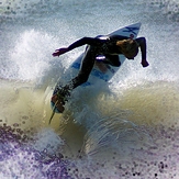
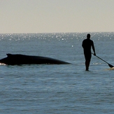
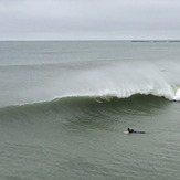
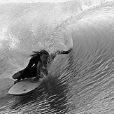
North Carolina Photos

North Carolina Wavefinder
Sun 2 | Monday 3 | Tuesday 4 | Wednesday 5 | Thursday 6 | Friday 7 | Saturday 8 | ||||||||||||||
PM | Night | AM | PM | Night | AM | PM | Night | AM | PM | Night | AM | PM | Night | AM | PM | Night | AM | PM | Night | |
Best forecast wave conditions in North Carolina | ||||||||||||||||||||
Wave Height (m) Direction Period (s) | S 7 | S 7 | S 7 | S 7 | SSW 7 | ESE 7 | SSW 6 | SE 7 | SE 6 | SSE 6 | S 6 | ESE 7 | SSE 6 | SSE 6 | SSE 8 | SE 8 | SE 8 | SE 8 | SE 8 | SE 7 |
510 | 510 | 343 | 400 | 394 | 37 | 82 | 44 | 47 | 67 | 61 | 36 | 46 | 52 | 64 | 91 | 101 | 67 | 93 | 44 | |
Wind (km/h) | ||||||||||||||||||||
Wind State on-shore cross-onshore cross-shore cross-offshore off-shore glassy | cross-on | on | cross-on | on | cross-on | off | glassy | off | on | cross-off | on | on | cross-off | on | cross-off | on | cross-off | cross-off | on | cross-on |
High Tide | 11:32PM0.78m | 12:03PM0.76m | 00:13AM0.73m | 12:06PM1.14m | 00:21AM1.01m | 1:46PM0.82m | 1:52AM0.63m | 2:54AM0.60m | 3:53PM0.88m | 4:01AM1.01m | 5:00PM0.92m | |||||||||
Low Tide | 5:35PM0.06m | 6:02AM0.02m | 6:24PM0.09m | 5:48AM0.05m | 7:19PM0.11m | 7:24AM0.01m | 7:30PM0.20m | 8:22PM0.13m | 8:15AM0.01m | 9:31PM0.14m | 8:14AM-0.03m | 10:28PM0.24m | 9:29AM0.10m | 11:51PM0.10m | ||||||
mm | 7 | 11 | 24 | 6 | 14 | 6 | 17 | 4 | 5 | 2 | 6 | 8 | 1 | — | — | — | — | — | — | — |
Max °C | 28 | 27 | 25 | 25 | 25 | 25 | 24 | 26 | 27 | 25 | 27 | 28 | 29 | 27 | 27 | 28 | 27 | 27 | 27 | 27 |
Min °C | 27 | 25 | 25 | 25 | 25 | 25 | 23 | 24 | 27 | 24 | 27 | 27 | 29 | 27 | 27 | 28 | 27 | 25 | 27 | 27 |
Chill °C | 28 | 27 | 25 | 25 | 25 | 25 | 24 | 26 | 27 | 25 | 27 | 28 | 29 | 27 | 27 | 28 | 27 | 27 | 27 | 27 |
— | — | 6:18 | — | — | 6:11 | — | — | 6:18 | — | — | 6:20 | — | — | 6:13 | — | — | 6:15 | — | — | |
8:07 | — | — | 8:07 | — | — | 8:06 | — | — | 8:08 | — | — | 8:07 | — | — | 8:02 | — | — | 8:01 | — | |
Swell 1 Height (m) Direction Period (s) | — | — | — | — | SE 8 | ESE 7 | SE 7 | ESE 7 | SE 6 | — | ESE 7 | ESE 7 | ESE 7 | E 10 | SSE 8 | SE 8 | SE 8 | SE 8 | SE 8 | SE 7 |
— | — | — | — | 9 | 37 | 52 | 19 | 47 | — | 32 | 29 | 30 | 2 | 64 | 91 | 101 | 67 | 93 | 44 | |
Swell 2 Height (m) Direction Period (s) | — | — | — | — | — | SSE 7 | — | — | — | — | E 13 | E 10 | E 10 | — | E 9 | E 9 | E 9 | E 9 | — | E 9 |
— | — | — | — | — | 16 | — | — | — | — | 3 | 2 | 2 | — | 2 | 2 | 2 | 1 | — | 2 | |
Wind waves Height (m) Direction Period (s) | S 7 | S 7 | S 7 | S 7 | SSW 7 | SSW 3 | SSW 6 | SE 7 | SSW 6 | SSE 6 | S 6 | S 5 | SSE 6 | SSE 6 | SW 4 | — | — | SW 3 | — | SSW 4 |
510 | 510 | 343 | 400 | 394 | 7 | 82 | 44 | 42 | 67 | 61 | 36 | 46 | 52 | 4 | — | — | 2 | — | 11 | |
Sea °C | 28 | 28 | 28 | 28 | 28 | 26 | 28 | 26 | 28 | 28 | 28 | 28 | 28 | 28 | 28 | 28 | 28 | 27 | 28 | 28 |
Diff °C | ||||||||||||||||||||
North Carolina Surf Breaks
Beach break, usually best in September, October, and November. Long flat beaches, great sunrises and sunsets.
This 3 block wide area known as sunskipper is very popular. Lately it has been not as great as usual. However there is almost a guarantee that you will pull into a barrel if not also make it out. At lower tides it will sometimes get kind of heavy and blasttastic. At a higher tide it can get kind of difficult to get in due to the rocks that are used to prevent erosion. Other than that it is a long flat beach facing ESE. Like most of the east coast it gets best during the fall because of hurricanes. Since the sandbar is so shallow so quick it is usually a foot or more bigger than most places in carolina beach and especially wrightsville beach. A couple blocks down is the north end pier with a jetty that is also a very fun place to surf but this is more a a longboard wave.
 Nearest