

San Onofre - Trails Surf Guide
Trails - San Onofre State Beach in San Diego County is an exposed beach break that has reasonably consistent surf. Summer offers the best conditions for surfing. Ideal winds are from the east. Tends to receive distant groundswells and the ideal swell direction is from the southwest. Waves at the beach are both lefts and rights. Best around mid tide when the tide is rising. Even when there are waves, it's not likley to be crowded. Hazards include .
San Onofre - Trails Spot Info
| Type: | Rating: | Reliability: | Todays Sea Temp*: |
|---|---|---|---|
| fairly consistent | 18.6°C*ocean temperature recorded from satellite |
Surfing San Onofre - Trails:
The best conditions reported for surf at San Onofre - Trails occur when a Southwest swell combines with an offshore wind direction from the East.
What's the best time of year to surf San Onofre - Trails (for consistent clean waves)?
Explore San Onofre - Trails Location Map
Interactive San Onofre - Trails surf break location map. View information about nearby surf breaks, their wave consistency and rating compared to other spots in the region. Current swell conditions from local buoys are shown along with live wind speed and direction from nearby weather stations. Click icons on the map for more detail. The closest passenger airport to San Onofre - Trails is John Wayne Arpt Orange Co (Santa Ana) Airport (SNA) in USA, 45 km (28 miles) away (directly). The second nearest airport to San Onofre - Trails is Tustin Mcaf Airport (NTK), also in USA, 46 km (29 miles) away.
- Map Icons:
 Break
Break Live Wave Height (m)
 Live Wind Speed (km/h)
 Surf Rating (10 Max)
 Ocean Swells (m)
- Wind Speed (km/h)
Tuesday, 9 June 2026, 19:48 Local Time
| Tue | Wed | |||
| 8PM | 11PM | 2AM | 5AM | |
| Wave (m) | ||||
| Period (s) | 18 | 18 | 18 | 18 |
| Wind (km/h) | ||||
| Wind State | glass | glass | cross- off |
glass |
Tides at San Onofre - Trails
| NEXT | IS AT (local time) | remaining |
|---|---|---|
| high tide | ||
| low tide |

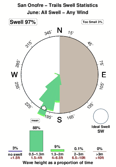
Swell History at San Onofre - Trails
Surf stats for San Onofre - Trails, see the swell variation by month or season on the history page here.


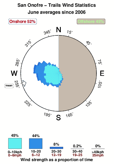
Wind History at San Onofre - Trails
Wind stats for San Onofre - Trails, see the variation in direction and stength by month or season on the history page here.
Other Nearby Breaks Closest To:
Discover surf breaks near San Onofre - Trails. Click below to view there surf guides.
- San Onofre
 Beach and point
 3.0
3.0
Reliability: consistent1km away - Church
- Beach and point
 4.0
4.0
Reliability: very consistent2km away - Trestles (Lowers)
- Beach and reef
- 4.0
Reliability: very consistent3km away - Trestles (Uppers)
 Reef and point
- 4.0
Reliability: very consistent4km away - Cottons Point
- Reef and point
 2.0
2.0
Reliability: consistent5km away
 Nearest