

Surf Forecasts:

How big are the waves at Liencres today (23 Jul):
- Morning surf: Morning surf (23 Jul, local time) - 3ft (0.9m), 6s period with NNE swell.
- Afternoon surf: Afternoon surf (23 Jul, local time) - 2.5ft (0.7m), 6s period with NNE swell.
- Evening surf: Evening surf (23 Jul, local time) - 2ft (0.6m), 6s period with NNW swell.
The current surf forecast for Liencres at 6AM is: 0.9m 6s primary swell from a North-northeast direction and 0.1m 10s secondary swell from a West direction (forecast issued at 01:00am July 23). The wind direction is predicted to be cross-offshore.
| Time (CEST) & Date | Wave Height | Wave Period |
|---|---|---|
| Morning (23 Jul) | 3ft (0.9m) | 6s |
| Afternoon (23 Jul) | 2.5ft (0.7m) | 6s |
| Evening (23 Jul) | 2ft (0.6m) | 6s |
Table - waves today at Liencres. (Swell directed towards the surf break)
Short Range ForecastLight rain (total 5mm), mostly falling on Sat night. Warm (max 23°C on Thu afternoon, min 19°C on Thu morning). Winds increasing (calm on Thu night, fresh winds from the W by Sat afternoon). | ||||||||||||||||||||||||
Thursday 23 | Friday 24 | Saturday 25 | ||||||||||||||||||||||
2 AM | 5 AM | 8 AM | 11 AM | 2 PM | 5 PM | 8 PM | 11 PM | 2 AM | 5 AM | 8 AM | 11 AM | 2 PM | 5 PM | 8 PM | 11 PM | 2 AM | 5 AM | 8 AM | 11 AM | 2 PM | 5 PM | 8 PM | 11 PM | |
Swell Height Map |  | 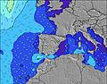 |  |  | 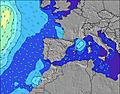 |  |  | 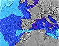 |  | |||||||||||||||
Wave Height (m) Direction Period (s) | NNE 6 | NNE 6 | NNE 6 | NNE 6 | NNE 6 | NNE 6 | NNW 6 | NNW 6 | NNW 6 | NNW 6 | NNW 6 | NNW 6 | NW 5 | WNW 5 | NW 6 | NW 6 | NW 6 | NW 6 | NW 6 | NW 6 | WNW 6 | NW 6 | NNW 6 | NNW 7 |
Wave Graph | ||||||||||||||||||||||||
77 | 57 | 54 | 54 | 27 | 27 | 30 | 30 | 31 | 30 | 21 | 25 | 31 | 36 | 67 | 60 | 60 | 69 | 83 | 135 | 202 | 187 | 229 | 316 | |
Wind (km/h) | ||||||||||||||||||||||||
Wind State on-shore cross-onshore cross-shore cross-offshore off-shore glassy | cross-off | cross-off | cross-off | cross-on | cross-on | cross | cross | glassy | cross-off | cross-off | cross-on | cross-on | cross-on | cross-on | cross-on | cross-on | cross-on | cross-on | cross-on | cross-on | cross-on | cross-on | on | on |
High Tide | 11:58PM2.73m | 12:35PM2.71m | 1:12AM2.62m | 1:48PM2.72m | 2:25AM2.65m | 2:52PM2.82m | ||||||||||||||||||
Low Tide | 6:07AM1.18m | 6:46PM1.23m | 7:16AM1.25m | 7:58PM1.21m | 8:22AM1.21m | 9:00PM1.10m | ||||||||||||||||||
— | 6:54 | — | — | — | — | — | — | — | 6:56 | — | — | — | — | — | — | — | 6:56 | — | — | — | — | — | — | |
— | — | — | — | — | — | 9:47 | — | — | — | — | — | — | — | 9:46 | — | — | — | — | — | — | — | 9:45 | — | |
mm | — | — | — | — | — | — | — | — | — | — | — | — | — | — | — | — | — | — | — | — | — | 1 | 2 | 1 |
Temp °C | 20 | 19 | 19 | 22 | 22 | 23 | 23 | 21 | 20 | 19 | 19 | 21 | 22 | 22 | 22 | 20 | 20 | 20 | 19 | 21 | 21 | 21 | 21 | 20 |
Feels °C | 19 | 18 | 18 | 22 | 23 | 23 | 24 | 22 | 20 | 19 | 18 | 20 | 20 | 20 | 20 | 17 | 18 | 17 | 16 | 17 | 16 | 17 | 18 | 17 |
Swell 1 Height (m) Direction Period (s) | NNE 6 | NNE 6 | NNE 6 | NNE 6 | NNE 6 | NNE 6 | NNW 6 | NNW 6 | NNW 6 | NNW 6 | NNW 6 | NE 5 | NE 5 | NNW 6 | NNE 6 | NW 6 | NW 6 | NW 6 | NW 6 | NE 5 | NW 11 | NW 11 | — | — |
77 | 57 | 54 | 54 | 27 | 27 | 30 | 30 | 31 | 30 | 21 | 13 | 14 | 24 | 12 | 60 | 60 | 69 | 83 | 1 | 5 | 5 | — | — | |
Swell 2 Height (m) Direction Period (s) | W 10 | W 10 | NW 9 | NW 9 | NNW 6 | NNW 6 | NNE 6 | NNE 5 | NNE 5 | NE 5 | NE 5 | W 9 | NE 5 | NE 6 | W 8 | NNE 6 | NE 5 | NNE 6 | NE 5 | NW 12 | N 11 | — | — | — |
2 | 2 | 3 | 3 | 20 | 20 | 20 | 19 | 19 | 14 | 13 | 2 | 14 | 15 | 1 | 12 | 7 | 3 | 1 | 5 | 2 | — | — | — | |
Swell 3 Height (m) Direction Period (s) | — | — | — | — | W 9 | NW 9 | W 9 | W 9 | W 9 | W 9 | W 9 | NW 9 | — | W 8 | — | W 8 | W 8 | W 8 | W 8 | N 12 | — | — | — | — |
— | — | — | — | 2 | 3 | 2 | 2 | 2 | 2 | 2 | 3 | — | 1 | — | 1 | 1 | 1 | 1 | 3 | — | — | — | — | |
Wind waves Height (m) Direction Period (s) | — | — | — | — | — | — | — | — | — | — | — | NNW 6 | NW 5 | WNW 5 | NW 6 | — | WNW 5 | — | — | NW 6 | WNW 6 | NW 6 | NNW 6 | NNW 7 |
— | — | — | — | — | — | — | — | — | — | — | 25 | 31 | 36 | 67 | — | 51 | — | — | 135 | 202 | 187 | 229 | 316 | |
Nearest Offshore or Glassy | ||||||||||||||||||||||||
Distance (km) | 0 | 0 | 0 | 8 | 9 | 9 | 9 | 0 | 0 | 0 | 90 | 349 | 381 | 134 | 116 | 90 | 90 | 109 | 125 | 178 | 1071 | 1071 | 42 | 42 |
Best forecast wave conditions in Spain - Cantabria | ||||||||||||||||||||||||
Best forecast wave conditions in Spain (Europe) | ||||||||||||||||||||||||
Header Global | ||||||||||||||||||||||||
- Map Icons:
 Break
Break Live Wave Height (m)
 Live Wind Speed (km/h)
 Surf Rating (10 Max)
 Ocean Swells (m)
- Wind Speed (km/h)


FREE! Surf-Forecast.com widget for your website
The surf report / weather widget below is available to embed on third party websites free of charge and provides a summary of our Liencres surf forecast. Simply grab the html code snippet that we provide and paste it into your own site. You can choose your preferred language and metric/imperial units for the surf forecast feed to suit users of your site. Click here to get the code.
 Nearest