
Bean Hollow State Beach Surf Guide
Bean Hollow State Beach in San Mateo is a fairly exposed beach and reef break that only works when conditions are just right. Summer offers the favoured conditions for surfing. Works best in offshore winds from the east. Most of the surf here comes from groundswells and the best swell direction is from the southwest. The left hand reef break is better than the right.. Best around mid tide. It very rarely gets crowded here. Hazards include rips and sharks.
Bean Hollow State Beach Spot Info
| Type: | Rating: | Reliability: | Todays Sea Temp*: |
|---|---|---|---|
| inconsistent | 12.1°C*ocean temperature recorded from satellite |
Surfing Bean Hollow State Beach:
The best conditions reported for surf at Bean Hollow State Beach occur when a Southwest swell combines with an offshore wind direction from the East.
What's the best time of year to surf Bean Hollow State Beach (for consistent clean waves)?
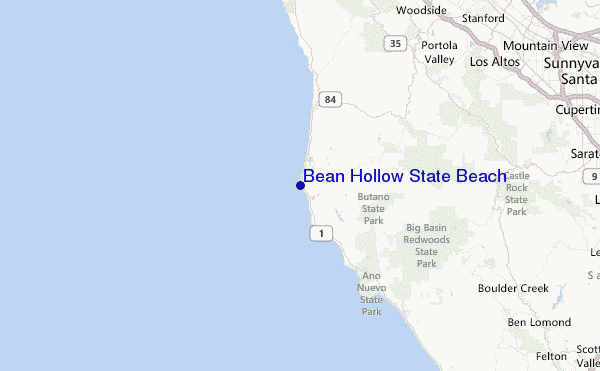
Explore Bean Hollow State Beach Location Map
Interactive Bean Hollow State Beach surf break location map. View information about nearby surf breaks, their wave consistency and rating compared to other spots in the region. Current swell conditions from local buoys are shown along with live wind speed and direction from nearby weather stations. Click icons on the map for more detail. The closest passenger airport to Bean Hollow State Beach is Moffett Federal Afld (Mountain View) Airport (NUQ) in USA, 38 km (24 miles) away (directly). The second nearest airport to Bean Hollow State Beach is San Francisco International Airport (SFO), also in USA, 43 km (27 miles) away.
- Map Icons:
 Break
Break Live Wave Height (m)
 Live Wind Speed (km/h)
 Surf Rating (10 Max)
 Ocean Swells (m)
- Wind Speed (km/h)
Wednesday, 10 June 2026, 07:09 Local Time
| Wednesday 10 | ||||
| 8AM | 11AM | 2PM | 5PM | |
| Wave (m) | ||||
| Period (s) | 9 | 9 | 18 | 10 |
| Wind (km/h) | ||||
| Wind State | cross | cross- on |
cross- on |
cross- on |
Tides at Bean Hollow State Beach
| NEXT | IS AT (local time) | remaining |
|---|---|---|
| high tide | ||
| low tide |
Bean Hollow State Beach Sea Temperature
Sunny with pleasant to warm air temperatures, yet the sea at Bean Hollow State Beach remains rather cold. Surfers will need a spring wetsuit and ideally neoprene hood, gloves and boots.

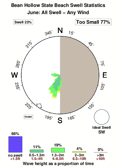
Swell History at Bean Hollow State Beach
Surf stats for Bean Hollow State Beach, see the swell variation by month or season on the history page here.

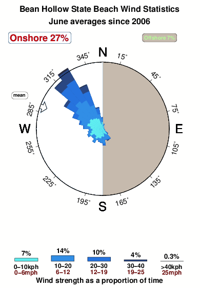
Wind History at Bean Hollow State Beach
Wind stats for Bean Hollow State Beach, see the variation in direction and stength by month or season on the history page here.
Other Nearby Breaks Closest To:
Discover surf breaks near Bean Hollow State Beach. Click below to view there surf guides.
- Pescadero State Beach
 Beach and reef
 2.0
2.0
Reliability: very consistent4km away - Pomponio State Beach
- Beach
- 2.0
Reliability: consistent6km away - Gazos Creek
- Beach
- 2.0
Reliability: inconsistent10km away - San Gregorio State Beach
- Beach
- 2.0
Reliability: fairly consistent10km away - Ano Nuevo
- Beach and reef
- 2.0
Reliability: inconsistent17km away
 Nearest