
- Forecast
- Maps
- Live
- Weather State
- Spot Information
Wategos Surf Forecast
/ NSW – North Coast (46 breaks) / New South Wales (297 breaks) /Surf Forecasts:


Wategos surfForecast / NSW – North Coast / Australia
Forecast update in hr min s Forecast update imminent
Wategos surf forecast is for near shore open water. Breaking waves will often be smaller at less exposed spots.
Today's Wategos sea temperature is
24.3° C
(Which is normal for this time of year)How big are the waves at Wategos today?
The current surf forecast for Wategos at 8PM is: 2.1m 8s primary swell from a East direction and 0.1m 17s secondary swell from a Southeast direction (forecast issued at 03:00pm April 30). An open ocean swell of 0.2m 8s is not directed at the surf break. The wind direction is predicted to be cross-offshore.
| Time (AEST) & Date | Wave Height | Wave Period |
|---|---|---|
| Morning (30 Apr) | - | - |
| Afternoon (30 Apr) | 7ft (2.1m) | 8s |
| Evening (30 Apr) | 6.5ft (2.0m) | 8s |
Table - waves today at Wategos. (Swell directed towards the surf break)
Updates in hr min s Forecast update imminent
Short Range ForecastHeavy rain (total 32mm), heaviest during Fri night. Warm (max 22°C on Fri morning, min 20°C on Thu night). Wind will be generally light. | ||||||||||||||||||||||||
Thu 30 | Friday 1 | Saturday 2 | Sun 3 | |||||||||||||||||||||
1 PM | 4 PM | 7 PM | 10 PM | 1 AM | 4 AM | 7 AM | 10 AM | 1 PM | 4 PM | 7 PM | 10 PM | 1 AM | 4 AM | 7 AM | 10 AM | 1 PM | 4 PM | 7 PM | 10 PM | 1 AM | 4 AM | 7 AM | 10 AM | |
Swell Height Map |    |    |    |  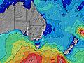 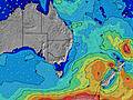 | ||||||||||||||||||||
ESE 8 | E 8 | E 8 | E 8 | E 8 | E 8 | E 8 | ESE 8 | ESE 8 | ESE 8 | ESE 8 | E 8 | E 8 | ESE 9 | E 9 | E 10 | E 10 | E 10 | E 10 | E 10 | E 10 | E 10 | E 10 | E 10 | |
599 | 588 | 588 | 548 | 548 | 539 | 552 | 574 | 575 | 511 | 449 | 535 | 878 | 1215 | 1251 | 1267 | 1232 | 1138 | 1047 | 1034 | 1076 | 1098 | 1000 | 980 | |
Wind (km/h) | ||||||||||||||||||||||||
cross-off | cross-off | cross-off | cross-off | cross-off | cross-off | cross-off | cross-off | cross-off | cross-off | cross-off | cross-off | cross-off | cross-off | cross-off | cross-off | cross-off | cross-off | cross-off | cross-off | cross-off | cross-off | cross-off | cross-off | |
High Tide | 7:19PM1.51m | 7:22AM1.21m | 7:53PM1.55m | 7:58AM1.15m | 8:27PM1.57m | 8:35AM1.08m | ||||||||||||||||||
Low Tide | 12:53PM0.10m | 1:36AM0.23m | 1:22PM0.11m | 2:16AM0.23m | 1:52PM0.13m | 2:56AM0.24m | ||||||||||||||||||
— | — | — | — | — | 6:11 | — | — | — | — | — | — | — | 6:11 | — | — | — | — | — | — | — | 6:13 | — | — | |
— | 5:13 | — | — | — | — | — | — | — | 5:13 | — | — | — | — | — | — | — | 5:12 | — | — | — | — | — | 5:10 | |
1 | 2 | — | 2 | 2 | 3 | 1 | — | — | 1 | 4 | 5 | 3 | 2 | 1 | 1 | — | — | — | — | 2 | 1 | — | 1 | |
Temp °C | 21 | 21 | 21 | 20 | 20 | 20 | 21 | 22 | 22 | 21 | 21 | 21 | 21 | 21 | 21 | 21 | 22 | 22 | 21 | 20 | 20 | 20 | 20 | 21 |
18 | 17 | 19 | 18 | 18 | 19 | 18 | 20 | 19 | 19 | 20 | 19 | 20 | 19 | 19 | 18 | 20 | 19 | 19 | 19 | 19 | 19 | 19 | 20 | |
Swell 1 Height (m) Direction Period (s) | S 9 | S 9 | S 8 | SSE 16 | SSE 15 | SSE 14 | SSE 13 | SE 12 | S 11 | S 10 | S 10 | S 10 | S 9 | S 9 | S 9 | S 8 | S 8 | E 10 | E 10 | E 10 | E 10 | E 10 | E 10 | E 10 |
6 | 6 | 6 | 25 | 22 | 19 | 17 | 6 | 2 | 2 | 8 | 2 | 2 | 2 | 6 | 6 | 5 | 1138 | 1047 | 1034 | 1076 | 1098 | 1000 | 980 | |
Swell 2 Height (m) Direction Period (s) | NE 14 | NE 14 | SE 17 | S 8 | S 8 | S 8 | NE 13 | NE 13 | NE 13 | NE 13 | NE 13 | NE 13 | NE 13 | N 13 | N 13 | S 19 | NE 12 | S 8 | S 18 | S 18 | S 17 | S 17 | S 15 | — |
8 | 8 | 11 | 6 | 1 | 5 | 7 | 7 | 7 | 7 | 7 | 7 | 7 | 3 | 4 | 7 | 6 | 5 | 6 | 6 | 6 | 6 | 4 | — | |
Swell 3 Height (m) Direction Period (s) | S 19 | S 18 | NE 15 | NE 15 | N 14 | N 13 | N 12 | N 12 | N 12 | N 12 | S 7 | N 12 | N 12 | — | N 13 | N 14 | S 19 | NE 12 | S 18 | — | S 17 | — | — | — |
7 | 6 | 8 | 8 | 4 | 3 | 3 | 3 | 3 | 3 | 1 | 3 | 3 | — | 4 | 4 | 7 | 6 | 6 | — | 6 | — | — | — | |
Wind waves Height (m) Direction Period (s) | ESE 8 | E 8 | E 8 | E 8 | E 8 | E 8 | E 8 | ESE 8 | ESE 8 | ESE 8 | ESE 8 | E 8 | E 8 | ESE 9 | E 9 | E 10 | E 10 | — | — | — | — | — | — | — |
599 | 588 | 588 | 548 | 548 | 539 | 552 | 574 | 575 | 511 | 449 | 535 | 878 | 1215 | 1251 | 1267 | 1232 | — | — | — | — | — | — | — | |
Nearest Offshore or Glassy | ||||||||||||||||||||||||
Distance (km) | 1 | 1 | 1 | 1 | 1 | 1 | 1 | 1 | 1 | 1 | 1 | 53 | 53 | 53 | 53 | 1 | 1 | 1 | 1 | 0 | 0 | 0 | 0 | 1 |
Best forecast wave conditions in North Coast - New South Wales | ||||||||||||||||||||||||
Best forecast wave conditions in Australia | ||||||||||||||||||||||||
Header Global | ||||||||||||||||||||||||
- Map Icons:
 Break
Break Live Wave Height (m)
 Live Wind Speed (km/h)
 Surf Rating (10 Max)
 Ocean Swells (m)
- Wind Speed (km/h)


FREE! Surf-Forecast.com widget for your website
The surf report / weather widget below is available to embed on third party websites free of charge and provides a summary of our Wategos surf forecast. Simply grab the html code snippet that we provide and paste it into your own site. You can choose your preferred language and metric/imperial units for the surf forecast feed to suit users of your site. Click here to get the code.
 Nearest