

- Forecast
- Maps
- Live
- Weather State
- Spot Information
Tarantulas Surf Forecast
/ CAL – Santa Barbara (36 breaks) / California (404 breaks) /
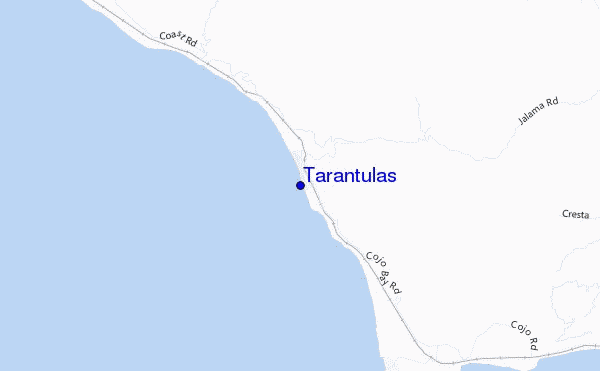
Tarantulas surf Forecast / CAL – Santa Barbara / USA
- Map Icons:
 Break
Break Live Wave Height (m)
 Live Wind Speed (km/h)
 Surf Rating (10 Max)
 Ocean Swells (m)
- Wind Speed (km/h)
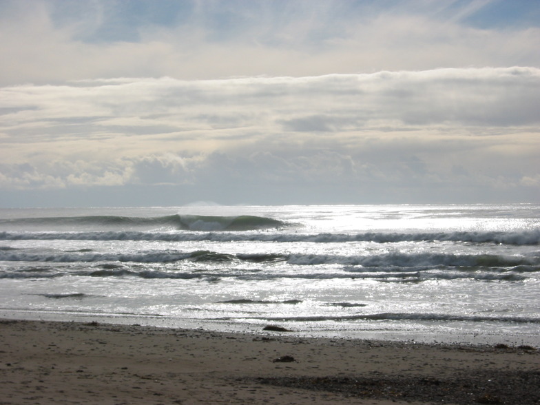
How big are the waves at Tarantulas today?
The current surf forecast for Tarantulas at 5AM is: 2.5m 8s primary swell from a Northwest direction and 0.7m 16s secondary swell from a Southwest direction, 0.4m 15s secondary swell from a West-northwest direction (forecast issued at 04:00am April 27). The wind direction is predicted to be cross-offshore and the swell rating is 2.
| Time (PDT) & Date | Wave Height | Wave Period |
|---|---|---|
| Morning (27 Apr) | 8ft (2.4m) | 8s |
| Afternoon (27 Apr) | 8ft (2.4m) | 8s |
| Evening (27 Apr) | 10ft (3.0m) | 8s |
Table - waves today at Tarantulas. (Swell directed towards the surf break)
Saturday 27 | Sunday 28 | Monday 29 | Tuesday 30 | Wednesday 01 | Thursday 02 | Friday 03 | Saturday 04 | |||||||||||||||||||||||||||||||||||||||||||||||||||||
| 2 AM | 5 AM | 8 AM | 11 AM | 2 PM | 5 PM | 8 PM | 11 PM | 2 AM | 5 AM | 8 AM | 11 AM | 2 PM | 5 PM | 8 PM | 11 PM | 2 AM | 5 AM | 8 AM | 11 AM | 2 PM | 5 PM | 8 PM | 11 PM | 2 AM | 5 AM | 8 AM | 11 AM | 2 PM | 5 PM | 8 PM | 11 PM | 2 AM | 5 AM | 8 AM | 11 AM | 2 PM | 5 PM | 8 PM | 11 PM | 2 AM | 5 AM | 8 AM | 11 AM | 2 PM | 5 PM | 8 PM | 11 PM | 2 AM | 5 AM | 8 AM | 11 AM | 2 PM | 5 PM | 8 PM | 11 PM | 2 AM | 5 AM | 8 AM | 11 AM | |
Rating (10 max) | ||||||||||||||||||||||||||||||||||||||||||||||||||||||||||||
Swell Height Map |    |    |    |   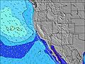 |  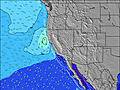 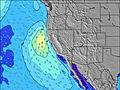 |  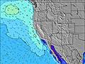 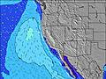 |  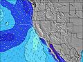 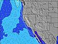 | 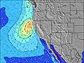 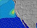 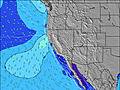 | ||||||||||||||||||||||||||||||||||||||||||||||||||||
| Wave Height (m) & direction (?) | ||||||||||||||||||||||||||||||||||||||||||||||||||||||||||||
| Period(s) (?) | 8 | 8 | 8 | 8 | 8 | 8 | 8 | 9 | 9 | 8 | 8 | 8 | 8 | 8 | 9 | 9 | 9 | 9 | 9 | 9 | 9 | 10 | 10 | 10 | 10 | 10 | 10 | 10 | 10 | 10 | 10 | 10 | 10 | 10 | 10 | 10 | 10 | 10 | 10 | 10 | 10 | 10 | 10 | 10 | 10 | 10 | 10 | 9 | 9 | 9 | 9 | 9 | 9 | 9 | 8 | 8 | 8 | 8 | 8 | 8 |
Wave (?)Graph | ||||||||||||||||||||||||||||||||||||||||||||||||||||||||||||
| Energy (?) | 885 | 801 | 717 | 682 | 771 | 919 | 1057 | 1225 | 1255 | 987 | 908 | 941 | 1173 | 1567 | 1830 | 2160 | 2027 | 1830 | 1802 | 1842 | 2013 | 2668 | 4154 | 4049 | 3172 | 2434 | 2282 | 2157 | 2152 | 2378 | 3090 | 3576 | 3506 | 2778 | 2340 | 2349 | 2326 | 2326 | 2834 | 3647 | 3339 | 2523 | 2091 | 1735 | 1546 | 1606 | 1368 | 1107 | 926 | 727 | 637 | 553 | 449 | 470 | 372 | 297 | 314 | 392 | 503 | 519 |
Wind (km/h) | ||||||||||||||||||||||||||||||||||||||||||||||||||||||||||||
| Wind State (?) onshore cross-onshore cross-shore cross-offshore offshore glassy | cross- off | cross- off | cross- off | cross- off | cross | cross- off | cross- off | cross- off | cross- off | cross- off | cross- off | cross | cross | cross- off | cross- off | cross- off | cross- off | cross- off | cross- off | cross- off | cross- off | cross- off | cross- off | cross- off | cross- off | cross- off | cross- off | cross | cross | cross- off | cross- off | cross- off | cross- off | cross- off | cross- off | cross | cross | cross- off | cross- off | cross- off | cross- off | cross- off | cross- off | cross | cross | cross- off | cross- off | cross- off | cross- off | cross- off | cross- off | cross | cross | cross- off | cross- off | cross- off | cross- off | cross- off | cross- off | cross |
High Tide / height (m) | 11:21PM 2.04 | 2:23PM 1.32 | 11:58PM 2.00 | 4:31PM 1.32 | 12:45AM 1.95 | 1:51AM 1.87 | 6:27PM 1.48 | 3:17AM 1.81 | 6:45PM 1.59 | 4:49AM 1.77 | 7:08PM 1.73 | 6:09AM 1.76 | 7:34PM 1.88 | 7:19AM 1.76 | ||||||||||||||||||||||||||||||||||||||||||||||
Low Tide / height (m) | 7:09AM 0.37 | 5:09PM 1.26 | 8:07AM 0.39 | 5:08PM 1.32 | 9:13AM 0.40 | 10:19AM 0.39 | 9:27PM 1.42 | 11:18AM 0.37 | 11:23PM 1.29 | 12:08PM 0.37 | 12:37AM 1.07 | 12:52PM 0.41 | 1:35AM 0.81 | |||||||||||||||||||||||||||||||||||||||||||||||
Saturday 27 | Sunday 28 | Monday 29 | Tuesday 30 | Wednesday 01 | Thursday 02 | Friday 03 | Saturday 04 | |||||||||||||||||||||||||||||||||||||||||||||||||||||
| Sunrise | - | - | 6:15 | - | - | - | - | - | - | - | 6:13 | - | - | - | - | - | - | - | 6:13 | - | - | - | - | - | - | - | 6:11 | - | - | - | - | - | - | - | 6:11 | - | - | - | - | - | - | - | 6:09 | - | - | - | - | - | - | - | 6:09 | - | - | - | - | - | - | - | 6:07 | - |
| Sunset | - | - | - | - | - | 7:44 | - | - | - | - | - | - | - | 7:44 | - | - | - | - | - | - | - | 7:45 | - | - | - | - | - | - | - | 7:45 | - | - | - | - | - | - | - | 7:46 | - | - | - | - | - | - | - | 7:47 | - | - | - | - | - | - | - | 7:47 | - | - | - | - | - | - |
Rain (mm) | - | - | - | - | - | - | - | - | - | - | - | - | - | - | - | - | - | - | - | - | - | - | - | - | - | - | - | - | - | - | - | - | - | - | - | - | - | - | - | - | - | - | - | - | - | - | - | - | - | - | - | - | - | - | - | - | - | - | - | - |
| Temp. °C | 12 | 11 | 11 | 15 | 14 | 14 | 11 | 11 | 11 | 11 | 13 | 16 | 16 | 15 | 12 | 11 | 11 | 10 | 12 | 14 | 15 | 14 | 11 | 11 | 11 | 11 | 13 | 17 | 17 | 15 | 12 | 11 | 11 | 11 | 12 | 19 | 17 | 16 | 12 | 11 | 11 | 11 | 13 | 18 | 18 | 17 | 12 | 11 | 12 | 12 | 13 | 16 | 16 | 15 | 11 | 11 | 11 | 10 | 12 | 13 |
| Feels °C (?) | 7 | 6 | 6 | 9 | 8 | 7 | 5 | 6 | 7 | 7 | 9 | 11 | 10 | 8 | 6 | 5 | 5 | 4 | 6 | 7 | 9 | 8 | 5 | 5 | 6 | 6 | 8 | 11 | 11 | 8 | 6 | 5 | 6 | 6 | 8 | 14 | 11 | 10 | 7 | 7 | 7 | 7 | 10 | 15 | 13 | 12 | 8 | 7 | 9 | 9 | 10 | 12 | 11 | 10 | 6 | 6 | 7 | 5 | 8 | 8 |
FREE! Surf-Forecast.com widget for your website
The surf report / weather widget below is available to embed on third party websites free of charge and provides a summary of our Tarantulas surf forecast. Simply grab the html code snippet that we provide and paste it into your own site. You can choose your preferred language and metric/imperial units for the surf forecast feed to suit users of your site. Click here to get the code.


 Nearest