
Samoa Peninsula Surf Guide
Samoa Peninsula in Humboldt is a reasonably exposed beach break that has pretty consitent surf and can work at any time of the year. Offshore winds are from the southeast. Tends to receive distant groundswells and the best swell direction is from the northwest. The beach break provides left and right handers. The quality of the surf isn't affected by the tide. When it's working here, it can get crowded. Take care of sharks,urchins, rips and rocks.
Samoa Peninsula Spot Info
| Type: | Rating: | Reliability: | Todays Sea Temp*: |
|---|---|---|---|
| fairly consistent | 11.1°C*ocean temperature recorded from satellite |
Surfing Samoa Peninsula:
The best conditions reported for surf at Samoa Peninsula occur when a Northwest swell combines with an offshore wind direction from the Southeast.
What's the best time of year to surf Samoa Peninsula (for consistent clean waves)?
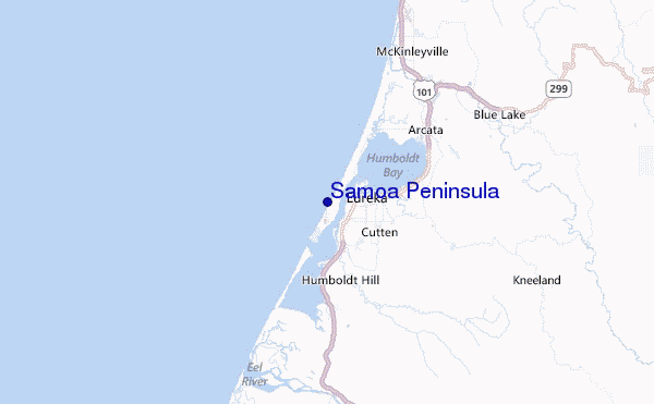
Explore Samoa Peninsula Location Map
Interactive Samoa Peninsula surf break location map. View information about nearby surf breaks, their wave consistency and rating compared to other spots in the region. Current swell conditions from local buoys are shown along with live wind speed and direction from nearby weather stations. Click icons on the map for more detail. The nearest passenger airport to Samoa Peninsula is Chico Muni Airport (CIC) in USA, which is 229 km (142 miles) away (directly). The second closest airport to Samoa Peninsula is Beale Afb (Marysville) Airport (BAB), also in USA, 300 km (186 miles) away.
- Map Icons:
 Break
Break Live Wave Height (m)
 Live Wind Speed (km/h)
 Surf Rating (10 Max)
 Ocean Swells (m)
- Wind Speed (km/h)
Wednesday, 10 June 2026, 02:57 Local Time
| Wednesday 10 | ||||
| 2AM | 5AM | 8AM | 11AM | |
| Wave (m) | ||||
| Period (s) | 10 | 10 | 10 | 10 |
| Wind (km/h) | ||||
| Wind State | cross | cross | cross- on |
cross- on |
Tides at Samoa Peninsula
| NEXT | IS AT (local time) | remaining |
|---|---|---|
| high tide | ||
| low tide |

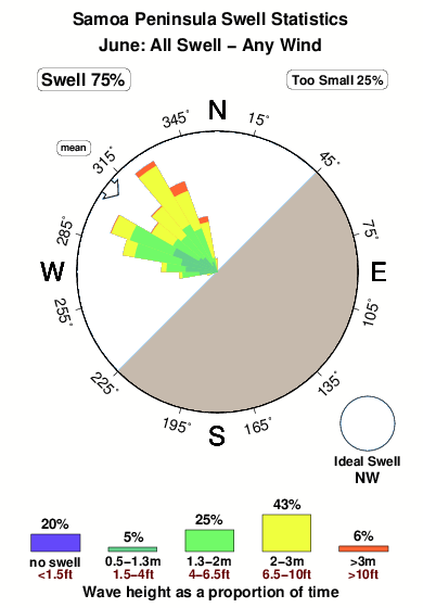
Swell History at Samoa Peninsula
Surf stats for Samoa Peninsula, see the swell variation by month or season on the history page here.

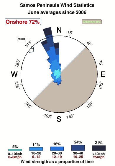
Wind History at Samoa Peninsula
Wind stats for Samoa Peninsula, see the variation in direction and stength by month or season on the history page here.
Other Nearby Breaks Closest To:
Discover surf breaks near Samoa Peninsula. Click below to view there surf guides.
- Bunkers
 Beach
Beach 2.0
2.0
Reliability: fairly consistent3km away - Harbor Entrance at Eureka
- Beach/harbormouth
- 2.0
Reliability: fairly consistent4km away - North Jetty at Eureka
- Beach/jetty
- 2.0
Reliability: fairly consistent4km away - South Jetty Table Bluff
 Beach
Beach- 2.0
Reliability: fairly consistent6km away - Mad River Beach
- Beach
 4.0
4.0
Reliability: inconsistent13km away
 Nearest