

Surf Forecasts:

How big are the waves at Faial - Praia do Norte today (10 Jun):
- Morning surf: Morning surf (10 Jun, local time) - 3ft (0.9m), 8s period with WNW swell.
- Afternoon surf: Afternoon surf (10 Jun, local time) - 2.5ft (0.8m), 9s period with NNW swell.
- Evening surf: Evening surf (10 Jun, local time) - 2.5ft (0.7m), 9s period with NNW swell.
The current surf forecast for Faial - Praia do Norte at 7AM is: 0.9m 9s primary swell from a North-northwest direction and 0.9m 8s secondary swell from a West-northwest direction (forecast issued at 11:00pm June 09). The wind direction is predicted to be onshore.
| Time (+00) & Date | Wave Height | Wave Period |
|---|---|---|
| Morning (10 Jun) | 3ft (0.9m) | 8s |
| Afternoon (10 Jun) | 2.5ft (0.8m) | 9s |
| Evening (10 Jun) | 2.5ft (0.7m) | 9s |
Table - waves today at Faial - Praia do Norte. (Swell directed towards the surf break)
Updates in hr min s Forecast update imminent
Short Range ForecastMostly dry. Very mild (max 19°C on Tue night, min 18°C on Tue night). Wind will be generally light. | ||||||||||||||||||||||||
Wednesday 10 | Thursday 11 | Friday 12 | ||||||||||||||||||||||
9 PM | 12 AM | 3 AM | 6 AM | 9 AM | 12 PM | 3 PM | 6 PM | 9 PM | 12 AM | 3 AM | 6 AM | 9 AM | 12 PM | 3 PM | 6 PM | 9 PM | 12 AM | 3 AM | 6 AM | 9 AM | 12 PM | 3 PM | 6 PM | |
Swell Height Map |  |  | 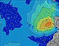 |  |  | 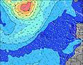 |  |  | 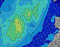 | 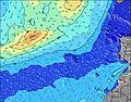 | ||||||||||||||
Wave Height (m) Direction Period (s) | NNW 9 | NNW 9 | WNW 9 | NNW 9 | WNW 8 | NNW 9 | NNW 9 | NNW 9 | NNW 9 | W 8 | W 8 | W 7 | NNW 8 | WNW 10 | WNW 10 | WNW 10 | WNW 10 | WNW 11 | WNW 11 | WNW 11 | WNW 10 | W 10 | W 10 | W 10 |
Wave Graph | ||||||||||||||||||||||||
149 | 121 | 119 | 119 | 96 | 94 | 92 | 90 | 82 | 59 | 55 | 40 | 38 | 38 | 116 | 146 | 176 | 202 | 202 | 187 | 173 | 198 | 190 | 194 | |
Wind (km/h) | ||||||||||||||||||||||||
Wind State on-shore cross-onshore cross-shore cross-offshore off-shore glassy | cross-on | cross-on | on | on | glassy | glassy | glassy | cross-on | cross-on | cross | cross-off | cross-off | cross-off | cross-off | cross-off | cross-off | cross-off | cross-off | cross-off | cross-off | off | off | off | off |
High Tide | 9:04PM1.05m | 9:52AM0.97m | 10:07PM1.10m | 10:52AM1.05m | 11:07PM1.15m | 11:47AM1.14m | ||||||||||||||||||
Low Tide | 3:36AM0.26m | 3:49PM0.33m | 4:34AM0.20m | 4:52PM0.27m | 5:28AM0.14m | 5:51PM0.20m | ||||||||||||||||||
— | — | — | 6:30 | — | — | — | — | — | — | — | 6:30 | — | — | — | — | — | — | — | 6:30 | — | — | — | — | |
9:17 | — | — | — | — | — | — | — | 9:17 | — | — | — | — | — | — | — | 9:19 | — | — | — | — | — | — | 9:19 | |
mm | — | — | — | — | — | — | — | — | — | — | — | — | — | — | — | — | — | — | — | — | — | — | — | — |
Temp °C | 19 | 19 | 18 | 18 | 18 | 19 | 19 | 19 | 19 | 19 | 19 | 18 | 18 | 19 | 19 | 19 | 19 | 19 | 19 | 19 | 19 | 19 | 19 | 19 |
Feels °C | 20 | 21 | 19 | 19 | 20 | 21 | 20 | 20 | 19 | 19 | 20 | 19 | 19 | 20 | 19 | 19 | 19 | 19 | 18 | 18 | 17 | 17 | 17 | 17 |
Swell 1 Height (m) Direction Period (s) | NNW 9 | WNW 9 | WNW 9 | WNW 8 | WNW 8 | WNW 8 | WNW 8 | WNW 8 | WNW 8 | W 8 | W 8 | W 7 | W 7 | W 7 | WNW 10 | WNW 10 | WNW 10 | WNW 11 | WNW 11 | WNW 11 | WNW 10 | W 10 | W 10 | W 10 |
149 | 101 | 108 | 103 | 96 | 87 | 85 | 65 | 65 | 58 | 41 | 40 | 27 | 27 | 116 | 146 | 176 | 202 | 202 | 187 | 173 | 198 | 190 | 194 | |
Swell 2 Height (m) Direction Period (s) | WNW 9 | NNW 9 | NNW 9 | NNW 9 | NNW 9 | NNW 9 | NNW 9 | NNW 9 | NNW 9 | NNW 9 | NNW 8 | NNW 8 | NNW 8 | NNW 8 | NNW 8 | NW 14 | NW 13 | NW 13 | NW 12 | NW 12 | NW 11 | NW 11 | NW 11 | NW 10 |
99 | 121 | 119 | 119 | 88 | 94 | 92 | 90 | 82 | 59 | 55 | 39 | 38 | 38 | 22 | 51 | 88 | 103 | 118 | 134 | 123 | 119 | 94 | 69 | |
Swell 3 Height (m) Direction Period (s) | S 11 | S 11 | S 11 | S 11 | S 11 | S 11 | S 11 | S 11 | S 11 | S 11 | N 10 | N 10 | WNW 10 | WNW 10 | NNW 15 | NNW 8 | NNW 8 | S 15 | S 15 | S 15 | S 15 | S 15 | S 14 | S 14 |
9 | 9 | 9 | 9 | 9 | 2 | 2 | 2 | 2 | 2 | 2 | 8 | 9 | 38 | 22 | 19 | 12 | 41 | 40 | 39 | 38 | 38 | 37 | 37 | |
Wind waves Height (m) Direction Period (s) | — | — | — | — | — | — | — | — | — | — | — | — | — | — | ESE 2 | ESE 2 | — | SE 2 | SE 3 | SE 3 | SSE 3 | S 3 | SSW 3 | S 3 |
— | — | — | — | — | — | — | — | — | — | — | — | — | — | 1 | 1 | — | 1 | 1 | 2 | 2 | 1 | 2 | 6 | |
Nearest Offshore or Glassy | ||||||||||||||||||||||||
Distance (km) | 14 | 14 | 1226 | 1221 | 0 | 0 | 0 | 1221 | 81 | 81 | 0 | 0 | 81 | 0 | 0 | 0 | 0 | 0 | 0 | 70 | 0 | 0 | 0 | 0 |
Best forecast wave conditions in The Azores | ||||||||||||||||||||||||
Best forecast wave conditions in Portugal | ||||||||||||||||||||||||
Header Global | ||||||||||||||||||||||||
- Map Icons:
 Break
Break Live Wave Height (m)
 Live Wind Speed (km/h)
 Surf Rating (10 Max)
 Ocean Swells (m)
- Wind Speed (km/h)


FREE! Surf-Forecast.com widget for your website
The surf report / weather widget below is available to embed on third party websites free of charge and provides a summary of our Faial - Praia do Norte surf forecast. Simply grab the html code snippet that we provide and paste it into your own site. You can choose your preferred language and metric/imperial units for the surf forecast feed to suit users of your site. Click here to get the code.
 Nearest