

Surf Forecasts:

How big are the waves at Lalafatna today (10 Jun):
- Morning surf: Morning surf (10 Jun, local time) - 7ft (2.1m), 9s period with NNW swell.
- Afternoon surf: Afternoon surf (10 Jun, local time) - 7ft (2.2m), 9s period with NNW swell.
- Evening surf: Evening surf (10 Jun, local time) - 7ft (2.1m), 9s period with NNW swell.
The current surf forecast for Lalafatna at 2AM is: 2.0m 8s primary swell from a North-northwest direction and 0.2m 10s secondary swell from a West direction (forecast issued at 06:00pm June 09). The wind direction is predicted to be cross-shore.
| Time (+01) & Date | Wave Height | Wave Period |
|---|---|---|
| Morning (10 Jun) | 7ft (2.1m) | 9s |
| Afternoon (10 Jun) | 7ft (2.2m) | 9s |
| Evening (10 Jun) | 7ft (2.1m) | 9s |
Table - waves today at Lalafatna. (Swell directed towards the surf break)
Updates in hr min s Forecast update imminent
Short Range ForecastMostly dry. Warm (max 21°C on Thu morning, min 18°C on Tue afternoon). Winds decreasing (fresh winds from the N on Tue afternoon, light winds from the N by Thu morning). | ||||||||||||||||||||||||
Tue 9 | Wednesday 10 | Thursday 11 | Fri 12 | |||||||||||||||||||||
4 PM | 7 PM | 10 PM | 1 AM | 4 AM | 7 AM | 10 AM | 1 PM | 4 PM | 7 PM | 10 PM | 1 AM | 4 AM | 7 AM | 10 AM | 1 PM | 4 PM | 7 PM | 10 PM | 1 AM | 4 AM | 7 AM | 10 AM | 1 PM | |
Swell Height Map | 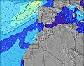 | 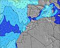 | 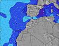 | 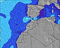 | 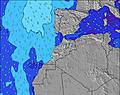 | 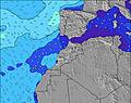 | 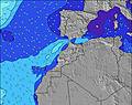 | 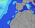 | 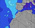 | |||||||||||||||
Wave Height (m) Direction Period (s) | NNW 8 | NNW 8 | NNW 8 | NNW 8 | NNW 9 | NNW 9 | NNW 9 | NNW 9 | NNW 9 | NNW 9 | NNW 9 | NNW 9 | NNW 9 | NNW 9 | NNW 9 | NNW 9 | NNW 9 | NNW 9 | NNW 9 | NNW 8 | NNW 9 | NNW 9 | NNW 9 | NNW 9 |
Wave Graph | ||||||||||||||||||||||||
463 | 468 | 480 | 537 | 601 | 732 | 749 | 798 | 781 | 781 | 718 | 734 | 672 | 658 | 601 | 573 | 573 | 495 | 426 | 255 | 286 | 273 | 238 | 207 | |
Wind (km/h) | ||||||||||||||||||||||||
Wind State on-shore cross-onshore cross-shore cross-offshore off-shore glassy | cross-on | cross-on | cross-on | cross | cross | cross | cross-on | cross-on | cross-on | cross-on | cross-on | cross-on | cross-on | cross-off | cross-on | cross-on | cross-on | cross-on | on | cross | cross-on | cross | cross | cross-on |
High Tide | 9:48PM2.23m | 10:33AM2.17m | 10:51PM2.32m | 11:32AM2.32m | 11:52PM2.43m | 12:27PM2.49m | ||||||||||||||||||
Low Tide | 3:27PM0.81m | 4:11AM0.60m | 4:35PM0.71m | 5:11AM0.49m | 5:37PM0.56m | 6:07AM0.37m | ||||||||||||||||||
— | — | — | — | 6:28 | — | — | — | — | — | — | — | 6:28 | — | — | — | — | — | — | — | 6:28 | — | — | — | |
— | 8:43 | — | — | — | — | — | — | — | 8:43 | — | — | — | — | — | — | — | 8:44 | — | — | — | — | — | 8:44 | |
mm | — | — | — | — | — | — | — | — | — | — | — | — | — | — | — | — | — | — | — | — | — | — | — | — |
Temp °C | 19 | 18 | 18 | 18 | 18 | 18 | 19 | 19 | 19 | 19 | 19 | 19 | 18 | 18 | 21 | 20 | 20 | 20 | 20 | 19 | 19 | 19 | 19 | 20 |
Feels °C | 15 | 14 | 14 | 15 | 16 | 16 | 17 | 17 | 16 | 17 | 17 | 18 | 18 | 18 | 22 | 19 | 18 | 19 | 22 | 20 | 20 | 20 | 20 | 20 |
Swell 1 Height (m) Direction Period (s) | NW 12 | WNW 10 | WNW 10 | NNW 8 | NNW 9 | NNW 9 | NNW 9 | NNW 9 | NNW 9 | NNW 9 | NNW 9 | NNW 9 | NNW 9 | NNW 9 | NNW 9 | NNW 9 | NNW 9 | NNW 9 | NNW 9 | NNW 8 | NNW 9 | NNW 9 | NNW 9 | NNW 9 |
50 | 19 | 33 | 537 | 601 | 732 | 749 | 798 | 781 | 781 | 718 | 734 | 672 | 658 | 601 | 573 | 573 | 495 | 426 | 255 | 286 | 273 | 238 | 207 | |
Swell 2 Height (m) Direction Period (s) | WNW 10 | — | — | W 10 | — | — | — | — | — | — | — | — | — | — | — | — | — | — | NE 7 | NW 10 | NE 7 | NNE 9 | NNE 9 | NNE 8 |
20 | — | — | 8 | — | — | — | — | — | — | — | — | — | — | — | — | — | — | 7 | 104 | 12 | 29 | 54 | 62 | |
Swell 3 Height (m) Direction Period (s) | — | — | — | — | — | — | — | — | — | — | — | — | — | — | — | — | — | — | — | NE 7 | — | — | — | — |
— | — | — | — | — | — | — | — | — | — | — | — | — | — | — | — | — | — | — | 12 | — | — | — | — | |
Wind waves Height (m) Direction Period (s) | NNW 8 | NNW 8 | NNW 8 | — | — | — | — | — | — | — | — | — | — | — | — | — | — | — | — | — | — | — | — | — |
463 | 468 | 480 | — | — | — | — | — | — | — | — | — | — | — | — | — | — | — | — | — | — | — | — | — | |
Nearest Offshore or Glassy | ||||||||||||||||||||||||
Distance (km) | 721 | 229 | 227 | 200 | 167 | 42 | 28 | 28 | 499 | 28 | 28 | 28 | 28 | 28 | 28 | 431 | 494 | 28 | 42 | 42 | 121 | 121 | 123 | 512 |
Best forecast wave conditions in Central Morocco | ||||||||||||||||||||||||
Best forecast wave conditions in Morocco | ||||||||||||||||||||||||
Header Global | ||||||||||||||||||||||||
- Map Icons:
 Break
Break Live Wave Height (m)
 Live Wind Speed (km/h)
 Surf Rating (10 Max)
 Ocean Swells (m)
- Wind Speed (km/h)


FREE! Surf-Forecast.com widget for your website
The surf report / weather widget below is available to embed on third party websites free of charge and provides a summary of our Lalafatna surf forecast. Simply grab the html code snippet that we provide and paste it into your own site. You can choose your preferred language and metric/imperial units for the surf forecast feed to suit users of your site. Click here to get the code.
 Nearest