

Grajagan Bay/G-Land Surf Guide
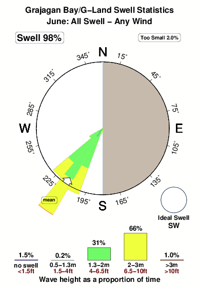
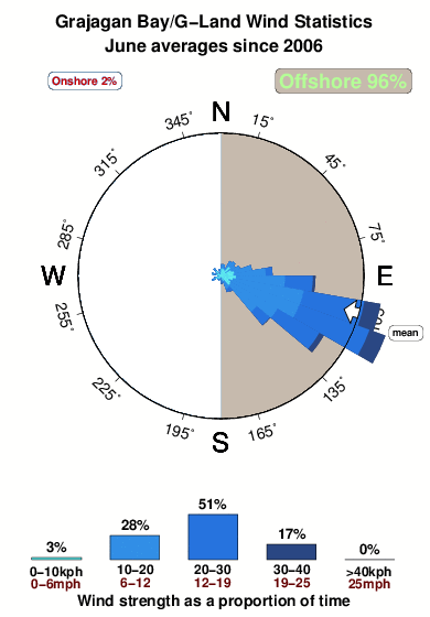
Grajagan Bay/G-Land in East Java is an exposed reef break that has very consistent waves. May-Oct (Dry Season) is the optimum time of year for waves. Offshore winds are from the east with some shelter here from southeast winds. Most of the surf here comes from groundswells and the best swell direction is from the southwest. A left hand reef break. Best around mid tide. When it's working here, it can get crowded. Beware of urchins, rocks and rips.
Grajagan Bay/G-Land Spot Info
| Type: | Rating: | Reliability: | Todays Sea Temp*: |
|---|---|---|---|
| very consistent | 28.0°C*ocean temperature recorded from satellite |
Surfing Grajagan Bay/G-Land:
The best conditions reported for surf at Grajagan Bay/G-Land occur when a Southwest swell combines with an offshore wind direction from the East.
What's the best time of year to surf Grajagan Bay/G-Land (for consistent clean waves)?
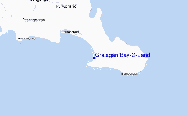
Explore Grajagan Bay/G-Land Location Map
Interactive Grajagan Bay/G-Land surf break location map. View information about nearby surf breaks, their wave consistency and rating compared to other spots in the region. Current swell conditions from local buoys are shown along with live wind speed and direction from nearby weather stations. Click icons on the map for more detail. The nearest passenger airport to Grajagan Bay/G-Land is Bali International (Denpasar) Airport (DPS) in Indonesia, which is 87 km (54 miles) away (directly). The second closest airport to Grajagan Bay/G-Land is Selaparang (Mataram) Airport (AMI), also in Indonesia, 190 km (118 miles) away.
- Map Icons:
 Break
Break Live Wave Height (m)
 Live Wind Speed (km/h)
 Surf Rating (10 Max)
 Ocean Swells (m)
- Wind Speed (km/h)
Wednesday, 10 June 2026, 21:57 Local Time
| Wed | Thursday 11 | |||
| 10PM | 1AM | 4AM | 7AM | |
| Wave (m) | ||||
| Period (s) | 16 | 16 | 16 | 17 |
| Wind (km/h) | ||||
| Wind State | off | off | off | off |
Tides at Grajagan Bay/G-Land
| NEXT | IS AT (local time) | remaining |
|---|---|---|
| high tide | ||
| low tide |
Swell History at Grajagan Bay/G-Land
Surf stats for Grajagan Bay/G-Land, see the swell variation by month or season on the history page here.

Wind History at Grajagan Bay/G-Land
Wind stats for Grajagan Bay/G-Land, see the variation in direction and stength by month or season on the history page here.
Grajagan Bay/G-Land Reviews:
Interactive Porthcawl Point location map. View nearby buoy information, live wind conditions and surrounding roads, paths and locations to help find new breaks. Click the buoys or wind icon to view more information.
- Overall:
 3.0
3.0 - Quality on a good day:
 4.6
4.6 - Consistency of Surf:4.8
- Difficulty Level:
 4.0
4.0 - Wind and Kite Surfing:
 1.5
1.5 - Crowds:3.4
Please check G-land latest Action on
www(dot)g-land(dot)com/glandjoyosurfcampsurfreport
also contact/email for Cheapest/affordable package
G-Land call centre Bali +62 (361) 763166,
Oz +61 (73) 040 1099 and US +1 (805) 308 3785 (Indo Time)”
Other Nearby Breaks Closest To:
Discover surf breaks near Grajagan Bay/G-Land. Click below to view there surf guides.
 Nearest