

- Forecast
- Maps
- Live
- Weather State
- Spot Information
Glenfield Surf Forecast
/ WA – North West (27 breaks) / Western Australia (159 breaks) /
Surf Forecasts
Beach
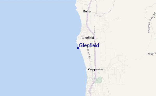
Glenfield surf Forecast / WA – North West / Australia
48hr Weather and Surf, issued 1 am Sunday 05 May 2024 AWST
Forecast update in hr min s Update imminent
Glenfield surf forecast is for near shore open water. Breaking waves will often be smaller at less exposed spots.
Today's Glenfield sea temperature is 23.0°C (Statistics for 05 May 1981-2005 - mean: 23.4 °C max: 25.1 °C min: 21.8 °C)
- Map Icons:
 Break
Break Live Wave Height (m)
 Live Wind Speed (km/h)
 Surf Rating (10 Max)
 Ocean Swells (m)
- Wind Speed (km/h)
Glenfield surf forecast is for near shore open water. Breaking waves will often be smaller at less exposed spots.
Today's Glenfield sea temperature is 23.0°C (Statistics for 05 May 1981-2005 - mean: 23.4 °C max: 25.1 °C min: 21.8 °C)
How big are the waves at Glenfield today?
The current surf forecast for Glenfield at 4AM is: 2.2m 16s primary swell from a Southwest direction and 1.1m 6s secondary swell from a South direction (forecast issued at 01:00am May 05). The wind direction is predicted to be cross-shore and the swell rating is 3.
| Time (AWST) & Date | Wave Height | Wave Period |
|---|---|---|
| Morning (05 May) | 7ft (2.1m) | 16s |
| Afternoon (05 May) | 6.5ft (2.0m) | 16s |
| Evening (05 May) | 6.5ft (2.0m) | 16s |
Table - waves today at Glenfield. (Swell directed towards the surf break)
Updates in hr min s Update imminent
Sunday 05 | Monday 06 | Tuesday 07 | Wednesday 08 | Thursday 09 | Friday 10 | Saturday 11 | Sunday 12 | |||||||||||||||||||||||||||||||||||||||||||||||||||||
| 11 PM | 2 AM | 5 AM | 8 AM | 11 AM | 2 PM | 5 PM | 8 PM | 11 PM | 2 AM | 5 AM | 8 AM | 11 AM | 2 PM | 5 PM | 8 PM | 11 PM | 2 AM | 5 AM | 8 AM | 11 AM | 2 PM | 5 PM | 8 PM | 11 PM | 2 AM | 5 AM | 8 AM | 11 AM | 2 PM | 5 PM | 8 PM | 11 PM | 2 AM | 5 AM | 8 AM | 11 AM | 2 PM | 5 PM | 8 PM | 11 PM | 2 AM | 5 AM | 8 AM | 11 AM | 2 PM | 5 PM | 8 PM | 11 PM | 2 AM | 5 AM | 8 AM | 11 AM | 2 PM | 5 PM | 8 PM | 11 PM | 2 AM | 5 AM | 8 AM | |
Rating (10 max) | ||||||||||||||||||||||||||||||||||||||||||||||||||||||||||||
Swell Height Map |  |    |    |    |    |    |    |    |  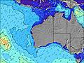 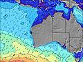 | |||||||||||||||||||||||||||||||||||||||||||||||||||
| Wave Height (m) & direction (?) | ||||||||||||||||||||||||||||||||||||||||||||||||||||||||||||
| Period(s) (?) | 16 | 16 | 16 | 16 | 16 | 16 | 16 | 16 | 15 | 15 | 15 | 14 | 14 | 14 | 14 | 14 | 13 | 13 | 13 | 13 | 13 | 13 | 13 | 17 | 16 | 16 | 16 | 15 | 14 | 14 | 13 | 14 | 14 | 13 | 13 | 13 | 13 | 13 | 13 | 13 | 12 | 12 | 12 | 13 | 13 | 12 | 12 | 12 | 12 | 12 | 12 | 11 | 11 | 12 | 12 | 12 | 12 | 12 | 12 | 12 |
Wave (?)Graph | ||||||||||||||||||||||||||||||||||||||||||||||||||||||||||||
| Energy (?) | 1728 | 2475 | 2475 | 2328 | 2160 | 1929 | 1933 | 1909 | 1169 | 924 | 1212 | 911 | 752 | 658 | 556 | 465 | 451 | 347 | 342 | 245 | 241 | 193 | 162 | 230 | 502 | 644 | 612 | 551 | 507 | 532 | 458 | 471 | 500 | 364 | 342 | 342 | 336 | 286 | 245 | 238 | 216 | 172 | 172 | 193 | 199 | 152 | 149 | 147 | 147 | 114 | 106 | 81 | 121 | 192 | 278 | 278 | 325 | 319 | 319 | 319 |
Wind (km/h) | ||||||||||||||||||||||||||||||||||||||||||||||||||||||||||||
| Wind State (?) onshore cross-onshore cross-shore cross-offshore offshore glassy | cross- off | cross- off | cross- off | cross- off | cross | cross | cross | cross | cross- off | cross- off | cross- off | cross- off | cross | cross- on | cross | cross | cross | cross- off | cross- off | cross- off | cross- off | cross | cross | cross | cross- off | cross- off | cross- off | off | off | off | off | cross- off | off | off | off | cross- off | cross- off | cross- on | cross- on | cross- on | cross | cross- off | cross- off | cross- off | cross- on | cross- on | on | on | cross | cross- off | cross- off | off | glass | cross- on | cross | cross | cross- off | cross- off | off | cross- off |
High Tide / height (m) | 8:14AM 0.54 | 8:44PM 0.40 | 8:28AM 0.62 | 10:15PM 0.36 | 8:49AM 0.69 | 9:13AM 0.75 | 9:40AM 0.78 | 10:09AM 0.77 | 10:36AM 0.74 | |||||||||||||||||||||||||||||||||||||||||||||||||||
Low Tide / height (m) | 1:54AM 0.24 | 3:26PM 0.22 | 1:48AM 0.30 | 4:10PM 0.12 | 1:27AM 0.33 | 4:55PM 0.05 | 5:42PM 0.01 | 6:33PM 0.01 | 7:30PM 0.04 | 8:59PM 0.07 | ||||||||||||||||||||||||||||||||||||||||||||||||||
Sunday 05 | Monday 06 | Tuesday 07 | Wednesday 08 | Thursday 09 | Friday 10 | Saturday 11 | Sunday 12 | |||||||||||||||||||||||||||||||||||||||||||||||||||||
| Sunrise | - | - | - | 6:50 | - | - | - | - | - | - | - | 6:50 | - | - | - | - | - | - | - | 6:52 | - | - | - | - | - | - | - | 6:52 | - | - | - | - | - | - | - | 6:52 | - | - | - | - | - | - | - | 6:54 | - | - | - | - | - | - | - | 6:54 | - | - | - | - | - | - | - | 6:54 |
| Sunset | - | - | - | - | - | - | 5:45 | - | - | - | - | - | - | - | 5:44 | - | - | - | - | - | - | - | 5:43 | - | - | - | - | - | - | - | 5:42 | - | - | - | - | - | - | - | 5:42 | - | - | - | - | - | - | - | 5:40 | - | - | - | - | - | - | - | 5:39 | - | - | - | - | - |
Rain (mm) | - | - | - | - | - | - | - | - | - | - | - | - | - | - | - | - | - | - | - | - | - | - | - | - | - | - | - | - | - | - | - | - | - | - | - | - | - | - | - | - | - | - | - | - | - | - | - | - | - | - | - | - | - | - | - | - | - | - | - | - |
| Temp. °C | 19 | 17 | 16 | 15 | 19 | 21 | 20 | 19 | 18 | 16 | 16 | 16 | 20 | 21 | 20 | 20 | 19 | 17 | 16 | 16 | 22 | 24 | 23 | 22 | 21 | 21 | 20 | 20 | 24 | 28 | 29 | 26 | 25 | 25 | 24 | 23 | 26 | 25 | 23 | 23 | 22 | 22 | 22 | 22 | 24 | 25 | 24 | 22 | 22 | 21 | 20 | 20 | 24 | 24 | 23 | 21 | 22 | 23 | 23 | 23 |
| Feels °C (?) | 14 | 13 | 12 | 12 | 15 | 16 | 15 | 15 | 14 | 13 | 13 | 14 | 17 | 18 | 17 | 17 | 16 | 14 | 13 | 13 | 18 | 20 | 18 | 19 | 18 | 16 | 15 | 14 | 18 | 22 | 23 | 21 | 19 | 17 | 16 | 16 | 20 | 20 | 20 | 23 | 23 | 23 | 23 | 22 | 23 | 24 | 24 | 23 | 24 | 22 | 20 | 20 | 24 | 22 | 21 | 20 | 21 | 22 | 20 | 19 |
FREE! Surf-Forecast.com widget for your website
The surf report / weather widget below is available to embed on third party websites free of charge and provides a summary of our Glenfield surf forecast. Simply grab the html code snippet that we provide and paste it into your own site. You can choose your preferred language and metric/imperial units for the surf forecast feed to suit users of your site. Click here to get the code.


 Nearest