

- Forecast
- Maps
- Live
- Weather State
- Spot Information
Boners Surf Forecast
/ CAL – San Luis Obispo (23 breaks) / California (404 breaks) /
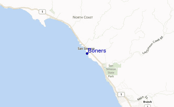
Boners surf Forecast / CAL – San Luis Obispo / USA
- Map Icons:
 Break
Break Live Wave Height (m)
 Live Wind Speed (km/h)
 Surf Rating (10 Max)
 Ocean Swells (m)
- Wind Speed (km/h)
How big are the waves at Boners today?
The current surf forecast for Boners at 12PM is: 2.2m 8s primary swell from a Northwest direction and 1.5m 8s secondary swell from a West-northwest direction, 0.7m 16s secondary swell from a Southwest direction (forecast issued at 10:00am April 27). The wind direction is predicted to be cross-shore and the swell rating is 2.
| Time (PDT) & Date | Wave Height | Wave Period |
|---|---|---|
| Morning (27 Apr) | 6ft (1.9m) | 8s |
| Afternoon (27 Apr) | 6ft (1.9m) | 8s |
| Evening (27 Apr) | 7.5ft (2.3m) | 8s |
Table - waves today at Boners. (Swell directed towards the surf break)
Saturday 27 | Sunday 28 | Monday 29 | Tuesday 30 | Wednesday 01 | Thursday 02 | Friday 03 | Saturday 04 | |||||||||||||||||||||||||||||||||||||||||||||||||||||
| 8 AM | 11 AM | 2 PM | 5 PM | 8 PM | 11 PM | 2 AM | 5 AM | 8 AM | 11 AM | 2 PM | 5 PM | 8 PM | 11 PM | 2 AM | 5 AM | 8 AM | 11 AM | 2 PM | 5 PM | 8 PM | 11 PM | 2 AM | 5 AM | 8 AM | 11 AM | 2 PM | 5 PM | 8 PM | 11 PM | 2 AM | 5 AM | 8 AM | 11 AM | 2 PM | 5 PM | 8 PM | 11 PM | 2 AM | 5 AM | 8 AM | 11 AM | 2 PM | 5 PM | 8 PM | 11 PM | 2 AM | 5 AM | 8 AM | 11 AM | 2 PM | 5 PM | 8 PM | 11 PM | 2 AM | 5 AM | 8 AM | 11 AM | 2 PM | 5 PM | |
Rating (10 max) | ||||||||||||||||||||||||||||||||||||||||||||||||||||||||||||
Swell Height Map |    |    |    |    |    |    |  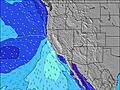 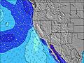 | 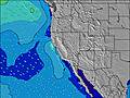 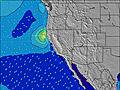 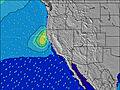 | ||||||||||||||||||||||||||||||||||||||||||||||||||||
| Wave Height (m) & direction (?) | ||||||||||||||||||||||||||||||||||||||||||||||||||||||||||||
| Period(s) (?) | 7 | 8 | 8 | 8 | 8 | 8 | 8 | 8 | 8 | 8 | 8 | 8 | 8 | 8 | 8 | 8 | 8 | 9 | 9 | 10 | 10 | 10 | 10 | 10 | 10 | 10 | 10 | 10 | 10 | 10 | 10 | 10 | 11 | 11 | 11 | 11 | 10 | 10 | 10 | 10 | 10 | 10 | 10 | 10 | 10 | 9 | 9 | 9 | 9 | 9 | 9 | 9 | 9 | 9 | 9 | 8 | 8 | 8 | 8 | 8 |
Wave (?)Graph | ||||||||||||||||||||||||||||||||||||||||||||||||||||||||||||
| Energy (?) | 349 | 567 | 422 | 546 | 638 | 1078 | 717 | 573 | 543 | 307 | 575 | 889 | 716 | 430 | 1078 | 1044 | 1208 | 1455 | 1131 | 1732 | 1667 | 2686 | 2152 | 1020 | 1898 | 1861 | 1207 | 1697 | 1855 | 3169 | 2450 | 1105 | 1016 | 1054 | 1006 | 1148 | 1063 | 919 | 785 | 692 | 601 | 520 | 471 | 490 | 394 | 389 | 339 | 311 | 572 | 621 | 404 | 439 | 419 | 1336 | 1242 | 512 | 500 | 559 | 898 | 1121 |
Wind (km/h) | ||||||||||||||||||||||||||||||||||||||||||||||||||||||||||||
| Wind State (?) onshore cross-onshore cross-shore cross-offshore offshore glassy | cross- off | cross | cross | cross | cross | cross- off | cross- off | cross- off | cross- off | cross | cross | cross | cross | cross- off | cross- off | cross- off | cross- off | cross | cross | cross | cross | cross- off | cross- off | cross- off | cross- off | cross | cross | cross | cross | cross- off | cross- off | cross- off | cross- off | cross | cross | cross | cross | cross- off | cross- off | cross- off | cross- off | cross | cross | cross | cross | cross- off | cross- off | cross- off | cross- off | cross | cross | cross | cross | cross- off | cross- off | cross- off | cross | cross | cross- on | cross- on |
High Tide / height (m) | 2:47PM 0.92 | 12:26AM 1.57 | 4:22PM 0.91 | 1:15AM 1.51 | 5:50PM 0.97 | 2:21AM 1.44 | 6:31PM 1.04 | 3:44AM 1.37 | 7:01PM 1.14 | 5:12AM 1.32 | 7:28PM 1.27 | 6:31AM 1.30 | 7:57PM 1.42 | 7:42AM 1.29 | ||||||||||||||||||||||||||||||||||||||||||||||
Low Tide / height (m) | 7:32AM -0.15 | 5:51PM 0.83 | 8:29AM -0.14 | 6:26PM 0.90 | 9:32AM -0.13 | 7:48PM 0.96 | 10:38AM -0.14 | 10:00PM 0.94 | 11:37AM -0.14 | 11:43PM 0.81 | 12:29PM -0.12 | 12:57AM 0.59 | 1:14PM -0.07 | 1:56AM 0.34 | 1:55PM 0.02 | |||||||||||||||||||||||||||||||||||||||||||||
Saturday 27 | Sunday 28 | Monday 29 | Tuesday 30 | Wednesday 01 | Thursday 02 | Friday 03 | Saturday 04 | |||||||||||||||||||||||||||||||||||||||||||||||||||||
| Sunrise | 6:16 | - | - | - | - | - | - | - | 6:15 | - | - | - | - | - | - | - | 6:13 | - | - | - | - | - | - | - | 6:13 | - | - | - | - | - | - | - | 6:11 | - | - | - | - | - | - | - | 6:09 | - | - | - | - | - | - | - | 6:09 | - | - | - | - | - | - | - | 6:07 | - | - | - |
| Sunset | - | - | - | 7:47 | - | - | - | - | - | - | - | 7:49 | - | - | - | - | - | - | - | 7:50 | - | - | - | - | - | - | - | 7:50 | - | - | - | - | - | - | - | 7:51 | - | - | - | - | - | - | - | 7:52 | - | - | - | - | - | - | - | 7:52 | - | - | - | - | - | - | - | 7:53 |
Rain (mm) | - | - | - | - | - | - | - | - | - | - | - | - | - | - | - | - | - | - | - | - | - | - | - | - | - | - | - | - | - | - | - | - | - | - | - | - | - | - | - | - | - | - | - | - | - | - | - | - | - | - | - | - | - | - | - | - | - | - | - | - |
| Temp. °C | 11 | 15 | 15 | 15 | 13 | 13 | 12 | 11 | 13 | 17 | 18 | 17 | 15 | 13 | 11 | 9 | 11 | 16 | 18 | 18 | 15 | 13 | 11 | 10 | 12 | 17 | 18 | 17 | 14 | 13 | 12 | 11 | 13 | 18 | 19 | 18 | 16 | 15 | 14 | 13 | 15 | 19 | 20 | 19 | 17 | 16 | 15 | 14 | 16 | 19 | 19 | 18 | 15 | 14 | 13 | 12 | 13 | 15 | 16 | 14 |
| Feels °C (?) | 9 | 13 | 10 | 10 | 9 | 10 | 9 | 8 | 11 | 14 | 12 | 10 | 10 | 9 | 7 | 5 | 7 | 11 | 12 | 12 | 10 | 9 | 8 | 7 | 9 | 13 | 12 | 11 | 9 | 9 | 8 | 8 | 11 | 15 | 14 | 12 | 12 | 12 | 11 | 10 | 13 | 16 | 16 | 15 | 14 | 13 | 12 | 11 | 14 | 16 | 15 | 14 | 11 | 12 | 11 | 9 | 10 | 11 | 12 | 11 |
FREE! Surf-Forecast.com widget for your website
The surf report / weather widget below is available to embed on third party websites free of charge and provides a summary of our Boners surf forecast. Simply grab the html code snippet that we provide and paste it into your own site. You can choose your preferred language and metric/imperial units for the surf forecast feed to suit users of your site. Click here to get the code.


 Nearest