

Surf Forecasts:

Playa Santa Teresa surf forecast from 3 Aug 2026:
- Best quality surf: Tuesday 4 Aug, 12AM (local time) - 2.5ft (0.7m), 13s period, SW swell with glassy winds.
- Most powerful swell: Saturday 8 Aug, 3PM (local time) - 3.5ft (1.0m), 15s period, SW swell with 435 kJ wave energy.
- Next surfable swell (1★+): Tuesday 4 Aug, 12AM (local time) - 2.5ft (0.7m), 13s period with SW swell.
Best Forecast Surf Conditions for Playa Santa Teresa this week:
The surf forecast for Playa Santa Teresa over the next 16 days: The first swell (rated 1 star or higher) is forecast to arrive on Tuesday (Aug 04) at 12AM. The primary swell is predicted to be 0.7m and 13s period. The wind is predicted to be glassy as the swell arrives.
The most powerful waves expected at Playa Santa Teresa in the next 16 days are 1.0m 15s and forecast to arrive on Saturday (Aug 08) at 3PM. Winds are predicted to be cross-onshore at the time the swell arrives. The largest open ocean swell (not directed at the beach) is 1.0m 8s period and expected on Tuesday (Aug 04) at 12AM.
| Wave Type | Time (CST) & Date | Wave Height & Period |
|---|---|---|
| Next good surf (1 star+) | 12AM (Tue 4th Aug) | 2.5ft (0.7m) 13s |
| Best Surf | 12AM (Tue 4th Aug) | 2.5ft (0.7m) 13s |
| Most Powerful | 3PM (Sat 8th Aug) | 3.5ft (1.0m) 15s |
Table - best surf conditions forecast for Playa Santa Teresa over the next 16 days.
The Lowdown
G’day, Rusty here. We’ve got a solid run of surf ahead for Playa Santa Teresa. The mix of consistent, clean mornings and a building swell window means there’s plenty to get excited about, especially if you’re after that classic Costa Rican beach-break feel. The water is sitting at a balmy 87°F, which is much warmer than normal for this time of year, so you’ll be in for a warm session.
The first real standout kicks off right away. Monday 3rd August morning – Playa Santa Teresa is showing a clean 3 ft SW groundswell with a nice long period of 13 seconds. The wind is glass – dead calm – and the combined energy of all swells directed here is a solid 272 (moderate). It’s going to be glassy, fun, and one of the best windows early on. The afternoon shifts to a light onshore breeze, so grab the early session.
Tuesday 4th August morning is another winner – 3 ft of SSW swell with a 9-second period, clean glassy conditions, and moderate energy at 235. The swell direction matches the optimum WNW direction nicely, so the waves should be well-shaped. The afternoon again gets a bit onshore, so keep it to the morning.
Wednesday 5th August morning drops a little – 1 ft SW groundswell, period of 15 seconds, glassy winds, but the energy is weak at 104. It’s surfable, but you’ll be searching for the good ones. A bit of a lull day.
Thursday 6th August is a write-off. The morning has a 12 mph cross-onshore wind from the south, making things choppy and messy. The afternoon isn’t much better. Sit this one out.
Friday 7th August morning – now we’re talking. A 2 ft SSW groundswell with a very long period of 18 seconds – that’s proper groundswell energy. Combined energy jumps to 378 (moderate), and the wind is glassy from the north. The waves will be clean, but that long period can make beach breaks a bit straight – still, it’s a quality morning session. The afternoon turns onshore and stormy, so be ready to get out early.
Saturday 8th August morning is another beauty – 3 ft SSW groundswell, 16 seconds period, dead calm, and energy at 463 (moderate). That’s a standout morning. The swell direction is a little off the optimum, but the glassy conditions make up for it.
Sunday 9th August morning – 3 ft SSW groundswell, 14 seconds period, light offshore breeze from the north-northeast, and energy at 369. Clean and fun. The afternoon has a light onshore breeze, but it’s still surfable.
Monday 10th August morning – 2 ft SW groundswell, 13 seconds, glassy, energy at 287. Another good morning window.
Tuesday 11th August morning – 2 ft SW groundswell, 14 seconds, dead calm, energy at 284. Classic glassy morning.
Wednesday 12th August morning – 2 ft SW groundswell, 16 seconds, light offshore from the northeast, energy at 376. Clean and well-shaped.
Thursday 13th August morning – 2 ft SW groundswell, 15 seconds, light offshore from the east-northeast, energy at 209. Still a solid morning.
Now, the true standout of the whole forecast. Friday 14th August morning – 3 ft SW groundswell, a massive 19 seconds period, light offshore wind from the north-northeast, and combined energy hitting 655 (moderate to strong). This is the best on offer. The long period will bring proper power and shape, and the offshore wind will keep it clean. The crowd profile at Playa Santa Teresa is listed as “sometimes,” so it might get a few heads, but with that quality, it’s worth it.
Saturday 15th August morning – 4 ft SW groundswell, 16 seconds, light offshore from the east-northeast, and energy at 755 (strong). This is a bigger, punchier session. The swell is over 3 ft, so it’s still fine for intermediates, but beginners might want to be careful. The morning is the window – the afternoon turns onshore.
Sunday 16th August morning – 4 ft SW groundswell, 15 seconds, glassy, energy at 485. Another strong morning.
The run then continues with smaller, clean mornings through Monday 17th and Tuesday 18th August, with the Tuesday morning showing a 2 ft SW groundswell, light cross-offshore breeze, and clean conditions.
Overall, the mornings are the story here. The afternoons nearly all get an onshore wind, so be a dawn patrol warrior. The best two sessions are Friday 14th August morning with that 19-second groundswell and offshore wind, and Saturday 15th August morning for the punchier 4 ft swell. Get amongst it.
Rusty.
Short Range ForecastHeavy rain (total 33mm), heaviest during Wed night. Warm (max 29°C on Mon morning, min 26°C on Wed night). Wind will be generally light. | Days 4-6 Weather SummaryHeavy rain (total 29mm), heaviest during Thu morning. Warm (max 29°C on Fri morning, min 26°C on Thu morning). Wind will be generally light. | ||||||||||||||||||||
Monday 3 | Tuesday 4 | Wednesday 5 | Thursday 6 | Friday 7 | Saturday 8 | Sunday 9 | |||||||||||||||
AM | PM | Night | AM | PM | Night | AM | PM | Night | AM | PM | Night | AM | PM | Night | AM | PM | Night | AM | PM | Night | |
Swell Height Map |  |  |  | 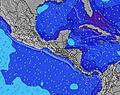 | 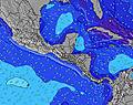 |  | 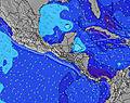 | ||||||||||||||
Wave Height (m) Direction Period (s) | SW 13 | SW 13 | SW 13 | SSW 9 | SSW 9 | SSW 8 | SW 15 | SW 12 | SW 15 | SW 14 | SSW 8 | SW 13 | SSW 18 | SW 17 | SSW 16 | SSW 16 | SW 15 | SSW 14 | SSW 14 | SW 14 | SW 13 |
Wave Graph | |||||||||||||||||||||
253 | 208 | 168 | 129 | 126 | 115 | 54 | 49 | 75 | 97 | 79 | 212 | 207 | 302 | 330 | 322 | 435 | 268 | 357 | 288 | 175 | |
Wind (km/h) | |||||||||||||||||||||
Wind State on-shore cross-onshore cross-shore cross-offshore off-shore glassy | glassy | on | glassy | glassy | on | glassy | glassy | on | glassy | cross-on | on | glassy | glassy | on | cross | glassy | cross-on | off | off | on | off |
High Tide | 5:54PM2.31m | 6:18AM2.50m | 6:35PM2.23m | 6:59AM2.47m | 7:21PM2.15m | 7:47AM2.42m | 8:16PM2.06m | 8:44AM2.37m | 9:22PM2.00m | 9:51AM2.33m | 10:36PM2.01m | 11:03AM2.35m | 11:51PM2.10m | ||||||||
Low Tide | 11:52AM0.43m | 11:59PM0.38m | 12:33PM0.45m | 00:38AM0.44m | 1:19PM0.48m | 1:24AM0.51m | 2:13PM0.52m | 2:18AM0.58m | 3:16PM0.55m | 3:24AM0.63m | 4:26PM0.53m | 4:38AM0.64m | 5:38PM0.46m | ||||||||
5:31 | — | — | 5:31 | — | — | 5:31 | — | — | 5:31 | — | — | 5:31 | — | — | 5:31 | — | — | 5:31 | — | — | |
— | 6:01 | — | — | 6:01 | — | — | 6:00 | — | — | 6:00 | — | — | 6:00 | — | — | 6:00 | — | — | 6:00 | — | |
mm | — | 2 | 3 | — | 2 | 7 | — | 2 | 17 | 8 | 5 | 4 | — | 3 | 3 | 2 | 4 | — | — | — | 3 |
Temp °C | 29 | 29 | 28 | 29 | 29 | 28 | 29 | 29 | 28 | 26 | 27 | 26 | 29 | 29 | 27 | 28 | 28 | 27 | 29 | 29 | 28 |
Feels °C | 33 | 32 | 32 | 32 | 32 | 32 | 32 | 32 | 32 | 28 | 30 | 30 | 33 | 32 | 31 | 33 | 32 | 30 | 33 | 32 | 33 |
Swell 1 Height (m) Direction Period (s) | SW 13 | SSW 7 | S 8 | SSW 9 | SSW 9 | SSW 8 | S 8 | S 8 | S 8 | S 8 | SSW 8 | SSW 10 | SW 13 | SW 12 | SSW 16 | SSW 16 | SW 15 | SSW 14 | SSW 14 | SW 14 | SW 13 |
253 | 69 | 144 | 129 | 126 | 115 | 105 | 105 | 100 | 98 | 79 | 128 | 168 | 148 | 330 | 322 | 435 | 268 | 357 | 288 | 175 | |
Swell 2 Height (m) Direction Period (s) | S 7 | SW 13 | SW 13 | SW 12 | SW 12 | SW 12 | SW 12 | SW 12 | SW 15 | SW 14 | SW 14 | SW 13 | S 10 | S 9 | SSW 8 | SW 12 | S 9 | S 9 | S 8 | S 10 | S 10 |
66 | 208 | 168 | 98 | 93 | 73 | 50 | 49 | 75 | 97 | 64 | 212 | 89 | 76 | 73 | 141 | 73 | 37 | 34 | 48 | 47 | |
Swell 3 Height (m) Direction Period (s) | WNW 10 | SW 16 | SW 16 | WNW 9 | WNW 9 | SW 12 | SW 15 | S 14 | SW 11 | SW 11 | SSW 11 | SSW 18 | SSW 18 | SW 17 | SW 12 | S 8 | — | SW 11 | SW 18 | SW 18 | SW 16 |
19 | 42 | 41 | 8 | 8 | 36 | 54 | 37 | 19 | 19 | 43 | 127 | 207 | 302 | 144 | 50 | — | 79 | 12 | 49 | 68 | |
Wind waves Height (m) Direction Period (s) | — | — | — | — | SSW 2 | — | — | — | — | — | — | N 2 | NW 8 | — | — | — | — | — | NNW 5 | — | — |
— | — | — | — | 1 | — | — | — | — | — | — | 1 | 3 | — | — | — | — | — | 3 | — | — | |
Nearest Offshore or Glassy | |||||||||||||||||||||
Distance (km) | 0 | 93 | 0 | 0 | 141 | 0 | 0 | 100 | 0 | 65 | 68 | 0 | 0 | 56 | 12 | 0 | 12 | 0 | 0 | 56 | 0 |
Best forecast wave conditions in Golfo de Nicoya | |||||||||||||||||||||
Best forecast wave conditions in Costa Rica | |||||||||||||||||||||
Header Global | |||||||||||||||||||||
- Map Icons:
 Break
Break Live Wave Height (m)
 Live Wind Speed (km/h)
 Surf Rating (10 Max)
 Ocean Swells (m)
- Wind Speed (km/h)
Latest Updates


FREE! Surf-Forecast.com widget for your website
The surf report / weather widget below is available to embed on third party websites free of charge and provides a summary of our Playa Santa Teresa surf forecast. Simply grab the html code snippet that we provide and paste it into your own site. You can choose your preferred language and metric/imperial units for the surf forecast feed to suit users of your site. Click here to get the code.
Information about the Playa Santa Teresa Surf forecast
The above surf forecast table for Playa Santa Teresa provides essential information for determining whether the surfing conditions will be good over the next 16 days. A general guide to surfing at Playa Santa Teresa can be found by selecting the local surf guide option on the grey menu. Our Playa Santa Teresa surf forecast is unique since it includes wave energy (power) that defines the real feel of the surf rather than just the height or the period. If you surf the same spot (Playa Santa Teresa) regularly then make a mental note of the wave energy from the surf forecast table each time you go. Very soon you may start to choose your surf days based on the wave energy alone combined with our forecast of favourable offshore wind conditions. Our star ratings will help here and of course you will also find the usual wave height and period predictions on our surf forecasts as well as a full break down of the swell components under our advanced users option (to reveal that, click the little Einstein character under the tide times).
Further information to help with frequently asked questions about our surf forecast for Playa Santa Teresa may be found under the help tab on the top menu and also by moving your mouse over the question marks on the surf forecast table itself. Please always bear in mind that the forecast is for near-shore open water and local factors at each surf break influence the actual breaking wave height, such as the beach / reef profile, water depths offshore and shelter.
Playa Santa Teresa is 51 km (32 miles) from Puntarenas. If you plan a holiday in Golfo de Nicoya, look for hotels and other accommodation in Puntarenas. Puntarenas has rooms for a wide range of budgets as well as car hire and transport links.
 Nearest