

- Forecast
- Maps
- Live
- Weather State
- Spot Information
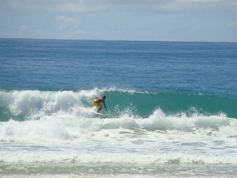
Tabatinga Surf Forecast
/ Rio Grande Do Norte (34 surf breaks) /
Surf Forecasts
Beach And Point
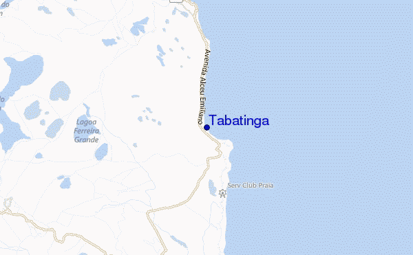
Tabatinga surf Forecast / Rio Grande Do Norte / Brazil
48hr Weather and Surf, issued 8 pm Tuesday 07 May 2024 -03
Forecast update in hr min s Update imminent
Tabatinga surf forecast is for near shore open water. Breaking waves will often be smaller at less exposed spots.
Today's Tabatinga sea temperature is 29.5°C (Statistics for 07 May 1981-2005 - mean: 28.2 °C max: 29.1 °C min: 27.3 °C)
- Map Icons:
 Break
Break Live Wave Height (m)
 Live Wind Speed (km/h)
 Surf Rating (10 Max)
 Ocean Swells (m)
- Wind Speed (km/h)
Tabatinga surf forecast is for near shore open water. Breaking waves will often be smaller at less exposed spots.
Today's Tabatinga sea temperature is 29.5°C (Statistics for 07 May 1981-2005 - mean: 28.2 °C max: 29.1 °C min: 27.3 °C)
How big are the waves at Tabatinga today?
The current surf forecast for Tabatinga at 2AM is: 1.4m 9s primary swell from a East-southeast direction and 0.5m 8s secondary swell from a North-northeast direction (forecast issued at 08:00pm May 07). The wind direction is predicted to be cross-shore and the swell rating is 2.
| Time (-03) & Date | Wave Height | Wave Period |
|---|---|---|
| Morning (08 May) | 5ft (1.5m) | 8s |
| Afternoon (08 May) | 5ft (1.6m) | 8s |
| Evening (08 May) | 5ft (1.6m) | 8s |
Table - waves today at Tabatinga. (Swell directed towards the surf break)
Updates in hr min s Update imminent
Tue 07 | Wednesday 08 | Thursday 09 | Friday 10 | Saturday 11 | Sunday 12 | Monday 13 | Tuesday 14 | Wed 15 | ||||||||||||||||||||||||||||||||||||||||||||||||||||
| 6 PM | 9 PM | 0 AM | 3 AM | 6 AM | 9 AM | 12 PM | 3 PM | 6 PM | 9 PM | 0 AM | 3 AM | 6 AM | 9 AM | 12 PM | 3 PM | 6 PM | 9 PM | 0 AM | 3 AM | 6 AM | 9 AM | 12 PM | 3 PM | 6 PM | 9 PM | 0 AM | 3 AM | 6 AM | 9 AM | 12 PM | 3 PM | 6 PM | 9 PM | 0 AM | 3 AM | 6 AM | 9 AM | 12 PM | 3 PM | 6 PM | 9 PM | 0 AM | 3 AM | 6 AM | 9 AM | 12 PM | 3 PM | 6 PM | 9 PM | 0 AM | 3 AM | 6 AM | 9 AM | 12 PM | 3 PM | 6 PM | 9 PM | 0 AM | 3 AM | |
Rating (10 max) | ||||||||||||||||||||||||||||||||||||||||||||||||||||||||||||
Swell Height Map |   |    |    |    |    |   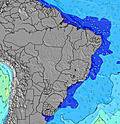 |  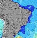 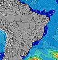 |  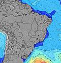 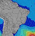 | 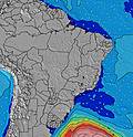 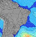 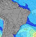 | |||||||||||||||||||||||||||||||||||||||||||||||||||
| Wave Height (m) & direction (?) | ||||||||||||||||||||||||||||||||||||||||||||||||||||||||||||
| Period(s) (?) | 9 | 9 | 9 | 9 | 8 | 8 | 9 | 8 | 8 | 8 | 8 | 8 | 8 | 9 | 9 | 9 | 9 | 9 | 9 | 9 | 9 | 9 | 9 | 9 | 9 | 9 | 10 | 10 | 10 | 10 | 10 | 10 | 9 | 9 | 9 | 10 | 10 | 10 | 10 | 10 | 10 | 10 | 10 | 10 | 10 | 9 | 9 | 9 | 9 | 9 | 9 | 9 | 9 | 9 | 9 | 9 | 9 | 9 | 9 | 9 |
Wave (?)Graph | ||||||||||||||||||||||||||||||||||||||||||||||||||||||||||||
| Energy (?) | 176 | 311 | 304 | 336 | 313 | 313 | 355 | 338 | 385 | 344 | 413 | 164 | 182 | 130 | 170 | 506 | 573 | 802 | 766 | 659 | 604 | 396 | 405 | 360 | 497 | 604 | 683 | 697 | 697 | 683 | 508 | 442 | 433 | 409 | 409 | 375 | 454 | 407 | 407 | 399 | 348 | 341 | 334 | 289 | 305 | 424 | 531 | 508 | 426 | 426 | 426 | 381 | 339 | 339 | 262 | 262 | 227 | 227 | 213 | 202 |
Wind (km/h) | ||||||||||||||||||||||||||||||||||||||||||||||||||||||||||||
| Wind State (?) onshore cross-onshore cross-shore cross-offshore offshore glassy | cross | cross | cross | cross- off | cross- off | cross | cross | cross | cross | cross- off | cross- off | cross- off | cross- off | cross | cross | cross | cross | cross | cross- off | cross- off | cross- off | cross- off | cross | cross | cross- off | cross | cross- off | cross- off | cross- off | cross- off | cross | cross | cross | cross | cross- off | cross- off | cross- off | cross- off | cross | cross | cross | cross | cross | cross- off | cross- off | cross- off | cross | cross | cross | cross | cross | cross- off | cross- off | cross- off | cross- off | cross | cross | cross | cross | cross- off |
High Tide / height (m) | 3:36PM 2.39 | 3:55AM 2.40 | 4:21PM 2.33 | 4:36AM 2.35 | 5:06PM 2.20 | 5:18AM 2.25 | 5:51PM 2.05 | 6:02AM 2.12 | 6:39PM 1.88 | 6:49AM 1.97 | 7:31PM 1.72 | 7:43AM 1.83 | 8:32PM 1.61 | 8:46AM 1.73 | 9:44PM 1.55 | |||||||||||||||||||||||||||||||||||||||||||||
Low Tide / height (m) | 9:43PM 0.05 | 10:07AM -0.03 | 10:25PM 0.11 | 10:51AM 0.01 | 11:06PM 0.22 | 11:35AM 0.11 | 11:48PM 0.36 | 12:22PM 0.24 | 12:34AM 0.51 | 1:14PM 0.40 | 1:25AM 0.65 | 2:14PM 0.55 | 2:28AM 0.77 | 3:25PM 0.65 | ||||||||||||||||||||||||||||||||||||||||||||||
Tue 07 | Wednesday 08 | Thursday 09 | Friday 10 | Saturday 11 | Sunday 12 | Monday 13 | Tuesday 14 | Wed 15 | ||||||||||||||||||||||||||||||||||||||||||||||||||||
| Sunrise | - | - | - | - | 5:20 | - | - | - | - | - | - | - | 5:20 | - | - | - | - | - | - | - | 5:20 | - | - | - | - | - | - | - | 5:20 | - | - | - | - | - | - | - | 5:20 | - | - | - | - | - | - | - | 5:20 | - | - | - | - | - | - | - | 5:20 | - | - | - | - | - | - | - |
| Sunset | - | - | - | - | - | - | - | 5:12 | - | - | - | - | - | - | - | 5:12 | - | - | - | - | - | - | - | 5:12 | - | - | - | - | - | - | - | 5:12 | - | - | - | - | - | - | - | 5:12 | - | - | - | - | - | - | - | 5:12 | - | - | - | - | - | - | - | 5:10 | - | - | - | - |
Rain (mm) | - | - | 1 | 1 | 2 | 4 | 1 | 1 | - | - | - | 1 | 1 | - | - | - | - | 1 | 1 | 1 | 1 | - | - | - | - | - | 1 | 1 | 1 | 1 | 2 | 4 | 2 | 4 | 2 | 2 | - | - | - | - | - | - | - | - | - | - | 1 | - | - | 1 | 4 | 5 | 2 | 2 | 3 | 1 | - | - | - | - |
| Temp. °C | 28 | 27 | 26 | 26 | 26 | 29 | 30 | 29 | 28 | 27 | 27 | 26 | 26 | 29 | 30 | 29 | 28 | 27 | 26 | 25 | 25 | 28 | 29 | 29 | 27 | 27 | 26 | 25 | 25 | 27 | 28 | 27 | 26 | 26 | 26 | 26 | 25 | 27 | 29 | 29 | 27 | 27 | 26 | 25 | 25 | 27 | 29 | 29 | 27 | 27 | 26 | 25 | 25 | 28 | 28 | 28 | 28 | 27 | 26 | 26 |
| Feels °C (?) | 31 | 30 | 29 | 29 | 29 | 31 | 31 | 30 | 30 | 29 | 31 | 30 | 29 | 32 | 32 | 30 | 30 | 30 | 29 | 27 | 27 | 30 | 30 | 30 | 29 | 30 | 28 | 27 | 27 | 28 | 29 | 29 | 28 | 29 | 29 | 29 | 27 | 29 | 31 | 31 | 29 | 30 | 29 | 28 | 28 | 30 | 32 | 31 | 30 | 31 | 29 | 28 | 28 | 30 | 30 | 30 | 31 | 30 | 29 | 29 |
FREE! Surf-Forecast.com widget for your website
The surf report / weather widget below is available to embed on third party websites free of charge and provides a summary of our Tabatinga surf forecast. Simply grab the html code snippet that we provide and paste it into your own site. You can choose your preferred language and metric/imperial units for the surf forecast feed to suit users of your site. Click here to get the code.


 Nearest