

Silver Strand Surf Guide
Silver Strand in Ventura is a fairly exposed beach break that has reasonably consistent surf The best wind direction is from the east. Tends to receive distant groundswells and the best swell direction is from the west northwest. The beach breaks offer lefts and rights. When it's working here, it can get crowded. Beware of urchins, rips and pollution.
Silver Strand Spot Info
| Type: | Rating: | Reliability: | Todays Sea Temp*: |
|---|---|---|---|
| fairly consistent | 16.4°C*ocean temperature recorded from satellite |
Surfing Silver Strand:
The best conditions reported for surf at Silver Strand occur when a West-northwest swell combines with an offshore wind direction from the East.
What's the best time of year to surf Silver Strand (for consistent clean waves)?
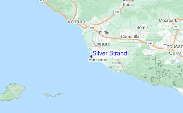
Explore Silver Strand Location Map
Interactive Silver Strand surf break location map. View information about nearby surf breaks, their wave consistency and rating compared to other spots in the region. Current swell conditions from local buoys are shown along with live wind speed and direction from nearby weather stations. Click icons on the map for more detail. The closest passenger airport to Silver Strand is Point Mugu Nas Airport (NTD) in USA, 10 km (6 miles) away (directly). The second nearest airport to Silver Strand is Los Angeles International Airport (LAX), also in USA, 79 km (49 miles) away.
- Map Icons:
 Break
Break Live Wave Height (m)
 Live Wind Speed (km/h)
 Surf Rating (10 Max)
 Ocean Swells (m)
- Wind Speed (km/h)
Wednesday, 10 June 2026, 06:16 Local Time
| Wednesday 10 | ||||
| 2AM | 5AM | 8AM | 11AM | |
| Wave (m) | ||||
| Period (s) | 18 | 18 | 18 | 17 |
| Wind (km/h) | ||||
| Wind State | glass | glass | glass | cross- on |
Tides at Silver Strand
| NEXT | IS AT (local time) | remaining |
|---|---|---|
| high tide | ||
| low tide |

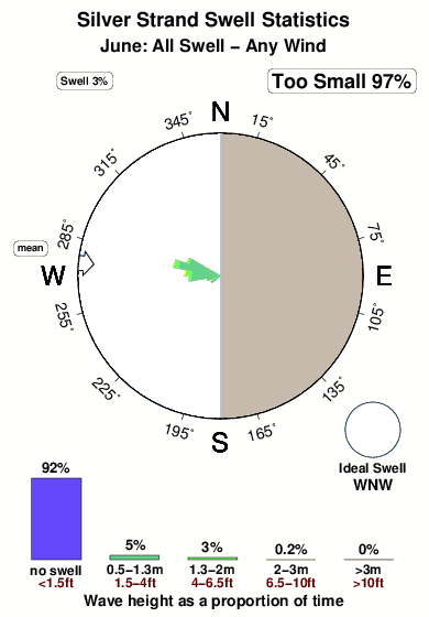
Swell History at Silver Strand
Surf stats for Silver Strand, see the swell variation by month or season on the history page here.

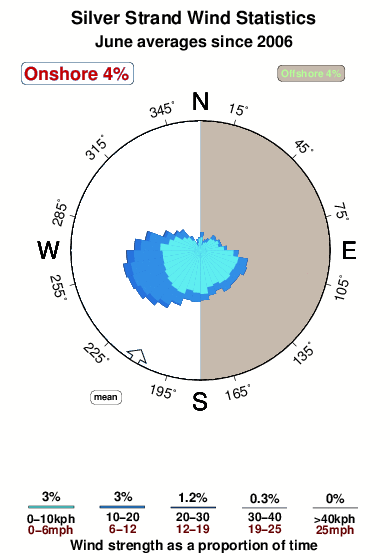
Wind History at Silver Strand
Wind stats for Silver Strand, see the variation in direction and stength by month or season on the history page here.
Other Nearby Breaks Closest To:
Discover surf breaks near Silver Strand. Click below to view there surf guides.
- Port Hueneme Beach Park
 Beach/jetty
 3.0
3.0
Reliability: fairly consistent1km away - Hollywood Beach
- Beach
 4.0
4.0
Reliability: fairly consistent2km away - Ormond Beach
- Beach/jetty
- 3.0
Reliability: fairly consistent4km away - Arnold
 Sandbar
- 3.0
Reliability: inconsistent7km away - Oxnard Shores
- Beach
 2.0
2.0
Reliability: fairly consistent9km away
 Nearest