

Playa Pantaleta Surf Guide
Playa Pantaleta in Caracas Area is an exposed reef break that has fairly consistent surf. Winter is the optimum time of year for surfing here. The best wind direction is from the south with some shelter here from east winds. Windswells and groundswells in equal measure and the ideal swell direction is from the north northeast. Both left and right reef breaks. Good surf at all stages of the tide. When the surf is up, it can get quite busy in the water. Beware of rocks,urchins and sharks.
Playa Pantaleta Spot Info
| Type: | Rating: | Reliability: | Todays Sea Temp*: |
|---|---|---|---|
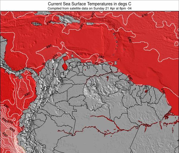
| fairly consistent | 26.1°C*ocean temperature recorded from satellite |
Surfing Playa Pantaleta:
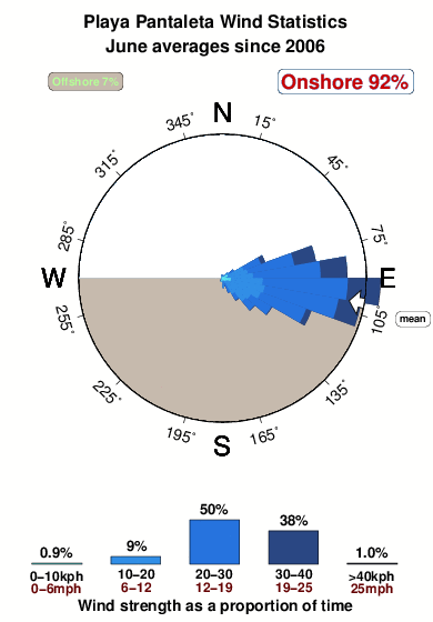
The best conditions reported for surf at Playa Pantaleta occur when a North-northeast swell combines with an offshore wind direction from the South.
What's the best time of year to surf Playa Pantaleta (for consistent clean waves)?
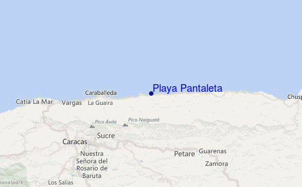
Explore Playa Pantaleta Location Map
Interactive Playa Pantaleta surf break location map. View information about nearby surf breaks, their wave consistency and rating compared to other spots in the region. Current swell conditions from local buoys are shown along with live wind speed and direction from nearby weather stations. Click icons on the map for more detail. The closest passenger airport to Playa Pantaleta is Simon Bolivar International (Caracas) Airport (CCS) in Venezuela, 30 km (19 miles) away (directly). The second nearest airport to Playa Pantaleta is Arturo Michelena International (Valencia) Airport (VLN), also in Venezuela, 143 km (89 miles) away.
- Map Icons:
 Break
Break Live Wave Height (m)
 Live Wind Speed (km/h)
 Surf Rating (10 Max)
 Ocean Swells (m)
- Wind Speed (km/h)
Wednesday, 10 June 2026, 15:45 Local Time
| Wednesday 10 | ||||
| 11AM | 2PM | 5PM | 8PM | |
| Wave (m) | ||||
| Period (s) | 6 | 6 | 6 | 6 |
| Wind (km/h) | ||||
| Wind State | cross | cross | cross | cross |
Tides at Playa Pantaleta
| NEXT | IS AT (local time) | remaining |
|---|---|---|
| high tide | ||
| low tide |
Swell History at Playa Pantaleta
Surf stats for Playa Pantaleta, see the swell variation by month or season on the history page here.


Wind History at Playa Pantaleta
Wind stats for Playa Pantaleta, see the variation in direction and stength by month or season on the history page here.
Playa Pantaleta Reviews:
Interactive Porthcawl Point location map. View nearby buoy information, live wind conditions and surrounding roads, paths and locations to help find new breaks. Click the buoys or wind icon to view more information.
- Overall:
 4.0
4.0 - Quality on a good day:3.7
- Consistency of Surf:
 2.9
2.9 - Difficulty Level:3.0
- Wind and Kite Surfing:
 2.2
2.2 - Crowds:2.1
Pelua Break (West End): At the western end, near the Malecón de Pelua, there’s a left-hand break that barrels beautifully during N and NNE swells with the right tide.
Central Peaks: Throughout the main stretch of the beach, various peaks form and shift depending on the movement of the sandbanks, providing ever-changing waves for surfers to explore.
El Fido (East End): At the eastern end, El Fido is a right-hand wave that performs well with NE swells, offering clean, powerful rides.
Historically, Playa Pantaleta was one of the most consistent and high-quality surf spots in La Guaira. However, after the devastating 1999 mudslide, the sandbanks haven’t recovered their ideal formation, and the consistency has decreased in recent years. Even so, Pantaleta remains one of the best spots for handling larger swells during cold fronts and storm surges.
The waves typically break from 1 to 6+ feet, and the beach holds size well in more significant conditions. While crowds can gather on good days, there are usually enough peaks for everyone. In my opinion, Pantaleta is the best wave on the eastern coast of the Litoral.
Warm water, a sandy bottom, and the spot's versatility make Playa Pantaleta a must-visit for surfers looking to experience La Guaira’s diverse surf scene.”
Other Nearby Breaks Closest To:
Discover surf breaks near Playa Pantaleta. Click below to view there surf guides.
 Nearest