
Piccaninnie Ponds Surf Guide
Piccaninnie Ponds on the East Coast is an exposed beach break that has fairly consistent surf, although summer tends to be mostly flat. The best wind direction is from the north. Tends to receive distant groundswells and the ideal swell direction is from the southwest. Waves at the beach break both left and right. A fairly popluar wave that can sometimes get crowded Beware of and sharks.
Piccaninnie Ponds Spot Info
| Type: | Rating: | Reliability: | Todays Sea Temp*: |
|---|---|---|---|
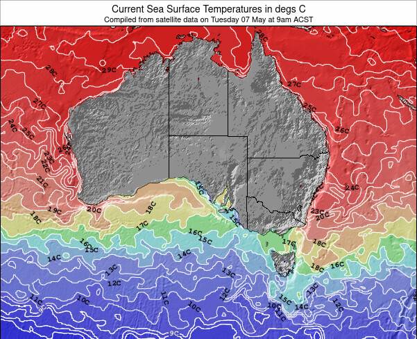
| fairly consistent | 16.1°C*ocean temperature recorded from satellite |
Surfing Piccaninnie Ponds:
The best conditions reported for surf at Piccaninnie Ponds occur when a Southwest swell combines with an offshore wind direction from the North.
What's the best time of year to surf Piccaninnie Ponds (for consistent clean waves)?
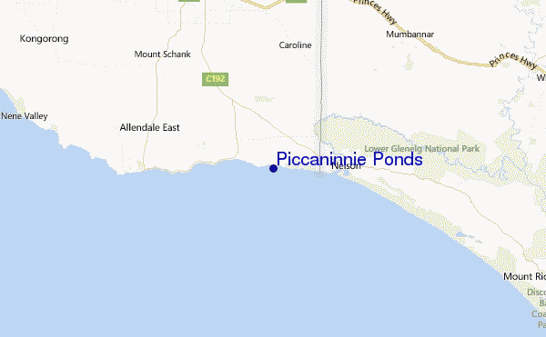
Explore Piccaninnie Ponds Location Map
Interactive Piccaninnie Ponds surf break location map. View information about nearby surf breaks, their wave consistency and rating compared to other spots in the region. Current swell conditions from local buoys are shown along with live wind speed and direction from nearby weather stations. Click icons on the map for more detail. The nearest passenger airport to Piccaninnie Ponds is Avalon Airport (AVV) in Australia, which is 313 km (194 miles) away (directly). The second closest airport to Piccaninnie Ponds is Melbourne International Airport (MEL), also in Australia, 349 km (217 miles) away.
- Map Icons:
 Break
Break Live Wave Height (m)
 Live Wind Speed (km/h)
 Surf Rating (10 Max)
 Ocean Swells (m)
- Wind Speed (km/h)
Wednesday, 10 June 2026, 16:21 Local Time
| Wednesday 10 | ||||
| 12:30PM | 3:30PM | 6:30PM | 9:30PM | |
| Wave (m) | ||||
| Period (s) | 14 | 14 | 14 | 17 |
| Wind (km/h) | ||||
| Wind State | cross | cross | cross- off |
off |
Tides at Piccaninnie Ponds
| NEXT | IS AT (local time) | remaining |
|---|---|---|
| high tide | ||
| low tide |
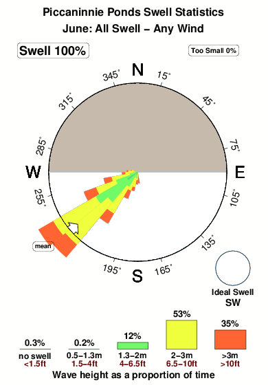
Swell History at Piccaninnie Ponds
Surf stats for Piccaninnie Ponds, see the swell variation by month or season on the history page here.

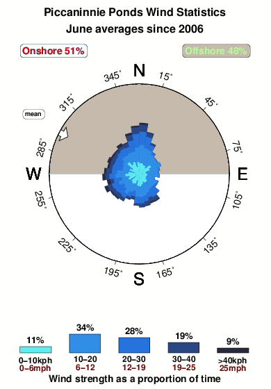
Wind History at Piccaninnie Ponds
Wind stats for Piccaninnie Ponds, see the variation in direction and stength by month or season on the history page here.
Other Nearby Breaks Closest To:
Discover surf breaks near Piccaninnie Ponds. Click below to view there surf guides.
- Glenelg Rivermouth
 Beach
Beach 3.0
3.0
Reliability: inconsistent9km away - Posties
 Reef
Reef- 3.0
Reliability: fairly consistent11km away - Douglas Point
- Reef
- 3.0
Reliability: fairly consistent13km away - Cape Northumberland
- Reef
- 3.0
Reliability: inconsistent20km away - Carpenters Rocks
- Reef and bombora
- 3.0
Reliability: fairly consistent48km away
 Nearest