
- Forecast
- Maps
- Live
- Weather State
- Spot Information
Mullaloo Surf Forecast
/ WA – Perth City (29 breaks) / Western Australia (159 breaks) /Surf Forecasts:


Mullaloo surfForecast / WA – Perth City / Australia
Forecast update in hr min s Forecast update imminent
Mullaloo surf forecast is for near shore open water. Breaking waves will often be smaller at less exposed spots.
Today's Mullaloo sea temperature is
23.7° C
(Which is 1.3°C warmer than normal for this time of year)How big are the waves at Mullaloo today?
The current surf forecast for Mullaloo at 3AM is: 1.2m 14s primary swell from a Southwest direction and 1.5m 8s secondary swell from a Southwest direction, 1.7m 8s secondary swell from a Southwest direction (forecast issued at 07:00pm March 21). The wind direction is predicted to be cross-shore.
| Time (AWST) & Date | Wave Height | Wave Period |
|---|---|---|
| Morning (22 Mar) | 4ft (1.2m) | 14s |
| Afternoon (22 Mar) | 4ft (1.2m) | 14s |
| Evening (22 Mar) | 3.5ft (1.1m) | 13s |
Table - waves today at Mullaloo. (Swell directed towards the surf break)
Updates in hr min s Forecast update imminent
Saturday 21 | Sunday 22 | Monday 23 | Tuesday 24 | |||||||||||||||||||||
| 5 PM | 8 PM | 11 PM | 2 AM | 5 AM | 8 AM | 11 AM | 2 PM | 5 PM | 8 PM | 11 PM | 2 AM | 5 AM | 8 AM | 11 AM | 2 PM | 5 PM | 8 PM | 11 PM | 2 AM | 5 AM | 8 AM | 11 AM | 2 PM | |
Rating (10 max) | ||||||||||||||||||||||||
Swell Height Map |  |  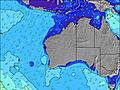 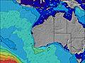 |  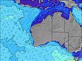 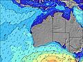 |  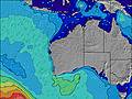 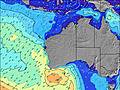 | ||||||||||||||||||||
| Wave Height (m) & direction (?) | ||||||||||||||||||||||||
| Period(s) (?) | 13 | 14 | 14 | 14 | 14 | 14 | 14 | 14 | 13 | 13 | 13 | 13 | 13 | 13 | 13 | 13 | 13 | 13 | 12 | 12 | 12 | 12 | 12 | 12 |
Wave (?)Graph | ||||||||||||||||||||||||
| 651 | 540 | 573 | 589 | 589 | 581 | 975 | 532 | 1613 | 406 | 465 | 954 | 851 | 721 | 653 | 535 | 479 | 411 | 392 | 473 | 416 | 361 | 409 | 278 | |
Wind (km/h) | ||||||||||||||||||||||||
| Wind State (?) onshore cross-onshore cross-shore cross-offshore offshore glassy | cross- on | cross- on | cross- on | cross | cross- off | cross | cross- on | cross- on | cross- on | cross- off | cross- off | cross- off | cross- off | cross- off | cross- off | cross | cross- off | cross- off | cross- off | cross- off | cross- off | cross- off | cross | cross- on |
High Tide / height (m) | 12:30AM 0.27 | 10:59AM 0.65 | 11:26AM 0.67 | 12:00PM 0.67 | ||||||||||||||||||||
Low Tide / height (m) | 6:17PM 0.17 | 3:09AM 0.26 | 7:52PM 0.16 | 12:33AM 0.11 | ||||||||||||||||||||
Saturday 21 | Sunday 22 | Monday 23 | Tuesday 24 | |||||||||||||||||||||
| Sunrise | - | - | - | - | - | 6:20 | - | - | - | - | - | - | - | 6:20 | - | - | - | - | - | - | - | 6:22 | - | - |
| Sunset | 6:28 | - | - | - | - | - | - | - | 6:25 | - | - | - | - | - | - | - | 6:24 | - | - | - | - | - | - | - |
Rain (mm) | - | - | - | - | - | - | - | - | - | - | - | - | - | - | - | - | - | - | - | - | - | - | - | - |
| Temp. °C | 21 | 21 | 20 | 20 | 19 | 19 | 23 | 23 | 23 | 25 | 20 | 18 | 18 | 18 | 23 | 27 | 28 | 22 | 19 | 17 | 17 | 17 | 24 | 23 |
| Feels °C (?) | 20 | 21 | 19 | 20 | 19 | 18 | 22 | 20 | 19 | 22 | 16 | 14 | 14 | 13 | 19 | 24 | 24 | 17 | 14 | 13 | 14 | 14 | 22 | 19 |
- Map Icons:
 Break
Break Live Wave Height (m)
 Live Wind Speed (km/h)
 Surf Rating (10 Max)
 Ocean Swells (m)
- Wind Speed (km/h)


FREE! Surf-Forecast.com widget for your website
The surf report / weather widget below is available to embed on third party websites free of charge and provides a summary of our Mullaloo surf forecast. Simply grab the html code snippet that we provide and paste it into your own site. You can choose your preferred language and metric/imperial units for the surf forecast feed to suit users of your site. Click here to get the code.
 Nearest