

Chadbourne Gulch Surf Guide
Chadbourne Gulch/Blues Beach in Mendocino County is an exposed beach break that has quite reliable surf. Summer offers the optimum conditions for surfing. Works best in offshore winds from the east. Tends to receive distant groundswells and the optimum swell angle is from the west southwest. Waves at the beach are both lefts and rights. Best around mid tide. When the surf is up, it can get quite busy in the water. Take care of sharks, rips, rocks and locals.
Chadbourne Gulch Spot Info
| Type: | Rating: | Reliability: | Todays Sea Temp*: |
|---|---|---|---|
| fairly consistent | 10.2°C*ocean temperature recorded from satellite |
Surfing Chadbourne Gulch:
The best conditions reported for surf at Chadbourne Gulch occur when a West-southwest swell combines with an offshore wind direction from the East.
What's the best time of year to surf Chadbourne Gulch (for consistent clean waves)?
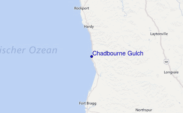
Explore Chadbourne Gulch Location Map
Interactive Chadbourne Gulch surf break location map. View information about nearby surf breaks, their wave consistency and rating compared to other spots in the region. Current swell conditions from local buoys are shown along with live wind speed and direction from nearby weather stations. Click icons on the map for more detail. The nearest passenger airport to Chadbourne Gulch is Chico Muni Airport (CIC) in USA, which is 166 km (103 miles) away (directly). The second closest airport to Chadbourne Gulch is Beale Afb (Marysville) Airport (BAB), also in USA, 209 km (130 miles) away.
- Map Icons:
 Break
Break Live Wave Height (m)
 Live Wind Speed (km/h)
 Surf Rating (10 Max)
 Ocean Swells (m)
- Wind Speed (km/h)
Wednesday, 10 June 2026, 03:46 Local Time
| Wednesday 10 | ||||
| 2AM | 5AM | 8AM | 11AM | |
| Wave (m) | ||||
| Period (s) | 19 | 18 | 18 | 18 |
| Wind (km/h) | ||||
| Wind State | cross | cross | cross | cross- on |
Tides at Chadbourne Gulch
| NEXT | IS AT (local time) | remaining |
|---|---|---|
| high tide | ||
| low tide |

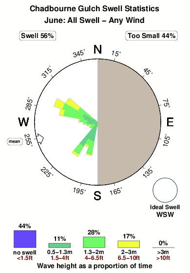
Swell History at Chadbourne Gulch
Surf stats for Chadbourne Gulch, see the swell variation by month or season on the history page here.

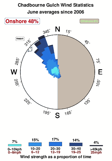
Wind History at Chadbourne Gulch
Wind stats for Chadbourne Gulch, see the variation in direction and stength by month or season on the history page here.
Other Nearby Breaks Closest To:
Discover surf breaks near Chadbourne Gulch. Click below to view there surf guides.
 Nearest