San Luis Obispo Surf
Detailed San Luis Obispo surf forecast maps and the latest eyeball surf report from local surfers in the region. Near-shore swell is shown on the map together with the surf forecast rating for spots in San Luis Obispo. Find the best places to surf in offshore conditions by selecting the wind option on the forecast map. Windsurfers and kite surfers can also use this option to find more favorable cross-shore conditions in San Luis Obispo. Our local Wavefinder indicates where some of the best conditions are likely to be found in San Luis Obispo over the next 7 days. Surf photos from San Luis Obispo and reviews of the best spots and surfing conditions have been provided by local surfers.
San Luis Obispo Surf Forecast map for predicting the best wave and wind conditions across the region. For surfers, the map shows the most powerful swell tracking across near-shore open water and not the peak waves experienced by boats out at sea. Move your mouse over the ocean swell symbols or the surf breaks on the coastline to see a more detailed surf forecast including wave period and wind conditions. The forecast updates every 6 hours and most live weather reports update every hour. You can animate the San Luis Obispo Surf map or show live wind and wave conditions as reported from wavebuoys and local weather stations. Surf breaks shown along the San Luis Obispo coastline are also listed below.
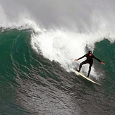
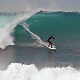
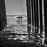
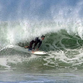
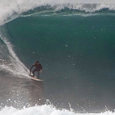
San Luis Obispo Photos
San Luis Obispo Wavefinder
Monday 3 | Tuesday 4 | Wednesday 5 | Thursday 6 | Friday 7 | Saturday 8 | Sunday 9 | |||||||||||||||
AM | PM | Night | AM | PM | Night | AM | PM | Night | AM | PM | Night | AM | PM | Night | AM | PM | Night | AM | PM | Night | |
Best forecast wave conditions in San Luis Obispo | |||||||||||||||||||||
Wave Height (m) Direction Period (s) | WNW 10 | WNW 10 | WNW 10 | WNW 9 | WNW 9 | SW 14 | SW 14 | SW 14 | WNW 8 | WNW 9 | WNW 9 | SSW 18 | SSW 19 | SSW 19 | SSW 17 | SSW 18 | SSW 16 | NW 8 | NW 10 | WNW 10 | NW 10 |
339 | 371 | 231 | 158 | 127 | 99 | 71 | 72 | 76 | 75 | 108 | 124 | 210 | 289 | 267 | 348 | 206 | 453 | 784 | 360 | 625 | |
Wind (km/h) | |||||||||||||||||||||
Wind State on-shore cross-onshore cross-shore cross-offshore off-shore glassy | cross-on | cross-on | glassy | cross-on | cross-on | cross-off | cross-on | cross-on | glassy | cross-on | cross-on | glassy | cross-on | cross-on | glassy | on | cross-on | glassy | glassy | cross-on | glassy |
High Tide | 2:17PM1.46m | 2:11AM1.12m | 2:56PM1.53m | 3:27AM0.08m | 3:42PM1.61m | 5:44AM0.88m | 4:40PM1.69m | 7:44AM0.93m | 5:44PM1.77m | 8:50AM1.02m | 6:48PM1.87m | 9:32AM1.11m | |||||||||
Low Tide | 8:37PM0.56m | 8:04AM0.45m | 9:53PM-0.43m | 8:36AM0.62m | 11:26PM0.36m | 9:21AM0.77m | 00:43AM0.12m | 10:38AM0.87m | 1:45AM-0.06m | 12:09PM0.90m | 2:38AM-0.22m | 1:26PM0.85m | 3:24AM-0.32m | ||||||||
mm | — | — | — | — | — | — | — | — | — | — | — | — | — | — | — | — | — | — | — | — | — |
Max °C | 17 | 21 | 16 | 21 | 21 | 15 | 21 | 21 | 16 | 22 | 22 | 19 | 24 | 24 | 20 | 22 | 23 | 17 | 19 | 23 | 16 |
Min °C | 14 | 20 | 15 | 16 | 21 | 14 | 17 | 20 | 15 | 19 | 22 | 18 | 20 | 23 | 19 | 19 | 22 | 17 | 18 | 21 | 14 |
Chill °C | 17 | 21 | 16 | 21 | 21 | 15 | 21 | 21 | 16 | 22 | 22 | 19 | 24 | 24 | 20 | 22 | 23 | 16 | 19 | 23 | 16 |
6:13 | — | — | 6:13 | — | — | 6:15 | — | — | 6:16 | — | — | 6:16 | — | — | 6:18 | — | — | 6:18 | — | — | |
— | 8:07 | — | — | 8:06 | — | — | 8:05 | — | — | 8:04 | — | — | 8:02 | — | — | 8:01 | — | — | 7:59 | — | |
Swell 1 Height (m) Direction Period (s) | WNW 10 | WNW 10 | WNW 10 | WNW 9 | WNW 9 | WNW 8 | WNW 8 | SW 14 | WNW 7 | SW 13 | SW 13 | W 5 | SSW 19 | SSW 19 | WNW 6 | WNW 8 | SSW 16 | WNW 8 | WNW 10 | WNW 10 | WNW 10 |
339 | 371 | 231 | 158 | 127 | 80 | 58 | 72 | 43 | 61 | 83 | 16 | 210 | 289 | 53 | 71 | 206 | 207 | 386 | 360 | 339 | |
Swell 2 Height (m) Direction Period (s) | SSW 13 | SW 13 | SW 12 | SW 15 | SW 15 | SW 14 | SW 14 | SW 11 | SW 14 | SSW 20 | SSW 20 | SSW 18 | W 5 | SW 13 | SSW 17 | SSW 18 | SSW 12 | SSW 16 | SSW 16 | SSW 15 | SSW 14 |
67 | 42 | 38 | 82 | 78 | 99 | 71 | 19 | 71 | 75 | 75 | 124 | 12 | 82 | 267 | 348 | 56 | 366 | 250 | 222 | 218 | |
Wind waves Height (m) Direction Period (s) | — | — | — | — | — | — | — | WNW 7 | WNW 8 | WNW 9 | WNW 9 | WNW 5 | — | WNW 5 | — | — | WNW 8 | NW 8 | NW 10 | — | NW 10 |
— | — | — | — | — | — | — | 43 | 76 | 71 | 108 | 25 | — | 17 | — | — | 108 | 453 | 784 | — | 625 | |
Sea °C | 15 | 14 | 14 | 14 | 14 | 15 | 14 | 14 | 15 | 14 | 14 | 14 | 14 | 14 | 14 | 14 | 14 | 14 | 14 | 15 | 14 |
Diff °C | |||||||||||||||||||||
San Luis Obispo Surf Breaks
San Luis Obispo has a mixture of sand and reef breaks. It might not be top of a California surfers 'to hit' list, but can offer some decent waves if the right conditions collide. The area has few sheltered spots and is usually blown out by mid day with NW prevailing winds. A few will have a sideshore/offshore condition from a NW but most breaks will need an SSE wind which usually comes with a storm. Morro Bay faces W giving it the best of most swells which on a good swell can light up the whole beach with A-frames and fast barrels, be prepared for crowds though. Hazard Canyon on it's day is epic although is unbelievably unforgiving, almost as much as the locals can be if you turn up in numbers. Pismo Beach is one of the more popular breaks which works best on a SE wind but with an array of shops and restaurants around the pier expect some big crowds when it's working.
 Nearest