
Ventura Overhead Surf Guide
Ventura Overhead in Ventura is a fairly exposed reef break that has unreliable waves. Winter is the best time of year for surfing here. Ideal winds are from the northeast. Groundswells are more common than windswells and the optimum swell angle is from the northwest. There are left and right breaking reefs. It's often crowded here. Watch out for dangerous rips.
Ventura Overhead Spot Info
| Type: | Rating: | Reliability: | Todays Sea Temp*: |
|---|---|---|---|
| inconsistent | 21.5°C*ocean temperature recorded from satellite |
Surfing Ventura Overhead:
The best conditions reported for surf at Ventura Overhead occur when a Northwest swell combines with an offshore wind direction from the Northeast.
What's the best time of year to surf Ventura Overhead (for consistent clean waves)?
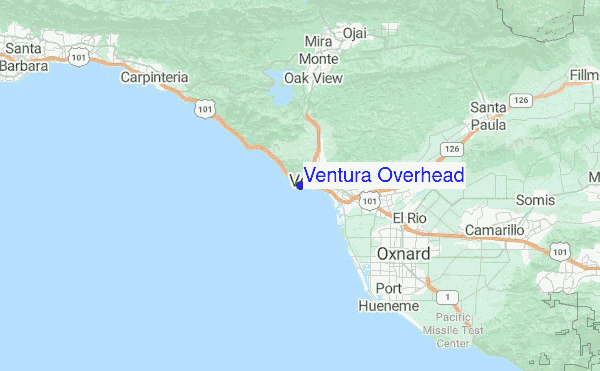
Explore Ventura Overhead Location Map
Interactive Ventura Overhead surf break location map. View information about nearby surf breaks, their wave consistency and rating compared to other spots in the region. Current swell conditions from local buoys are shown along with live wind speed and direction from nearby weather stations. Click icons on the map for more detail. The closest passenger airport to Ventura Overhead is Point Mugu Nas Airport (NTD) in USA, 25 km (16 miles) away (directly). The second nearest airport to Ventura Overhead is Burbank Glendale Pasadena Airport (BUR), also in USA, 89 km (55 miles) away.
- Map Icons:
 Break
Break Live Wave Height (m)
 Live Wind Speed (km/h)
 Surf Rating (10 Max)
 Ocean Swells (m)
- Wind Speed (km/h)
Monday, 3 August 2026, 02:30 Local Time
| Monday 03 | ||||
| 2AM | 5AM | 8AM | 11AM | |
| Wave (m) | ||||
| Period (s) | 13 | 6 | 6 | 6 |
| Wind (km/h) | ||||
| Wind State | on | cross- on |
on | cross- on |
Tides at Ventura Overhead
| NEXT | IS AT (local time) | remaining |
|---|---|---|
| high tide | ||
| low tide |

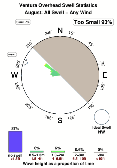
Swell History at Ventura Overhead
Surf stats for Ventura Overhead, see the swell variation by month or season on the history page here.

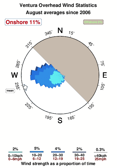
Wind History at Ventura Overhead
Wind stats for Ventura Overhead, see the variation in direction and stength by month or season on the history page here.
Ventura Overhead Reviews:
Interactive Porthcawl Point location map. View nearby buoy information, live wind conditions and surrounding roads, paths and locations to help find new breaks. Click the buoys or wind icon to view more information.
- Overall:
 3.0
3.0 - Quality on a good day:
 4.0
4.0 - Consistency of Surf:
 1.5
1.5 - Difficulty Level:4.0
- Crowds:2.5
Shore break got fun on smaller swells.
First introduced to short board “V” bottoms by Nat Young and Bob Mctavish. Went home that weekend and cut two feet off my 9’0” Morey Pope and reshaped the nose. Life changing for me. Next board was 5’8”.”
Other Nearby Breaks Closest To:
Discover surf breaks near Ventura Overhead. Click below to view there surf guides.
- Emma Wood State Beach
 Beach and reef
- 2.0
Reliability: fairly consistent1km away - Ventura Point
 Reef and point
- 3.0
Reliability: very consistent1km away - San Buenaventura State Beach
- Beach
- 3.0
Reliability: consistent4km away - Solimar Reef
- Beach and reef
- 2.0
Reliability: inconsistent5km away - New Jetty/South Jetty
- Beach
- 3.0
Reliability: fairly consistent6km away
 Nearest