

Shipwrecks Bay-Peaks Surf Guide
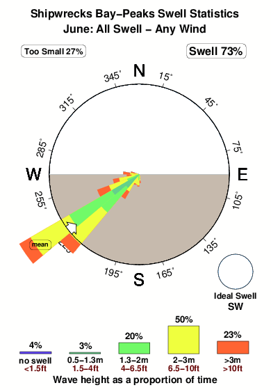
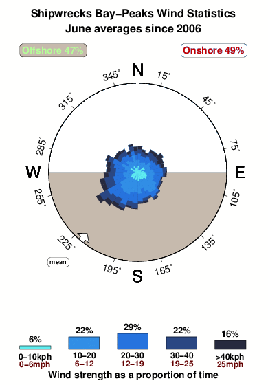
Shipwrecks Bay-Peaks in Northland is a sheltered reef break that has quite reliable surf The best wind direction is from the south. Surfable in an onshore breeze Tends to receive distant groundswells and the best swell direction is from the southwest. A left hand reef. Best around low tide when the tide is rising. Rarely crowded here. Beware of rips and rocks.
Shipwrecks Bay-Peaks Spot Info
| Type: | Rating: | Reliability: | Todays Sea Temp*: |
|---|---|---|---|
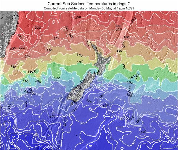
| fairly consistent | 16.8°C*ocean temperature recorded from satellite |
Surfing Shipwrecks Bay-Peaks:
The best conditions reported for surf at Shipwrecks Bay-Peaks occur when a Southwest swell combines with an offshore wind direction from the South.
What's the best time of year to surf Shipwrecks Bay-Peaks (for consistent clean waves)?
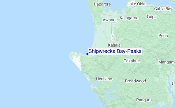
Explore Shipwrecks Bay-Peaks Location Map
Interactive Shipwrecks Bay-Peaks surf break location map. View information about nearby surf breaks, their wave consistency and rating compared to other spots in the region. Current swell conditions from local buoys are shown along with live wind speed and direction from nearby weather stations. Click icons on the map for more detail. The closest passenger airport to Shipwrecks Bay-Peaks is Kaitaia Airport (KAT) in New Zealand, which is 17 km (11 miles) away (directly). The second nearest airport to Shipwrecks Bay-Peaks is Kerikeri Airport (KKE), also in New Zealand, 71 km (44 miles) away.
- Map Icons:
 Break
Break Live Wave Height (m)
 Live Wind Speed (km/h)
 Surf Rating (10 Max)
 Ocean Swells (m)
- Wind Speed (km/h)
Sunday, 21 June 2026, 16:58 Local Time
| Sunday 21 | Mon | |||
| 3PM | 6PM | 9PM | 0AM | |
| Wave (m) | ||||
| Period (s) | 12 | 17 | 16 | 16 |
| Wind (km/h) | ||||
| Wind State | cross- on |
cross | cross- off |
off |
Tides at Shipwrecks Bay-Peaks
| NEXT | IS AT (local time) | remaining |
|---|---|---|
| high tide | ||
| low tide |
Swell History at Shipwrecks Bay-Peaks
Surf stats for Shipwrecks Bay-Peaks, see the swell variation by month or season on the history page here.

Wind History at Shipwrecks Bay-Peaks
Wind stats for Shipwrecks Bay-Peaks, see the variation in direction and stength by month or season on the history page here.
Shipwrecks Bay-Peaks Reviews:
Interactive Porthcawl Point location map. View nearby buoy information, live wind conditions and surrounding roads, paths and locations to help find new breaks. Click the buoys or wind icon to view more information.
- Overall:
 4.0
4.0 - Quality on a good day:4.3
- Consistency of Surf:
 2.7
2.7 - Difficulty Level:2.9
- Wind and Kite Surfing:
 1.3
1.3 - Crowds:
 2.3
2.3
Not a reef break, but sand bottom off lava rock points.
Very consistant in winter, and works when ever west coast is 3m plus. 4m swell on open coast ideal, mostly low tide but good all tides if swell big.
Peaks the most crowded, but crowds well spread out on a good day.
Can only drive around bluff from half tide to low.”
Other Nearby Breaks Closest To:
Discover surf breaks near Shipwrecks Bay-Peaks. Click below to view there surf guides.
- Mukerau Beach
 Beach
Beach- 3.0
Reliability: fairly consistent2km away - Ninety Mile Beach
 Beach
Beach- 2.0
Reliability: consistent2km away - Shipwreck Bay-Supertubes
 Reef
Reef- 4.0
Reliability: fairly consistent3km away - Shipwreck Bay-Pines
- Beach and reef
- 3.0
Reliability: fairly consistent4km away - Shipwreck Bay-Blue House
- Reef
- 3.0
Reliability: fairly consistent6km away
 Nearest