
Indicators Surf Guide
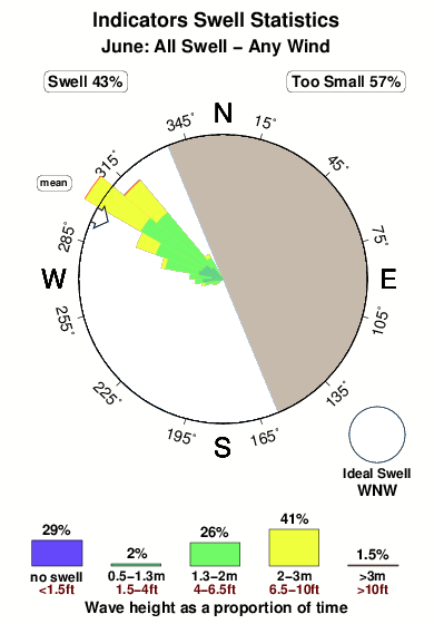
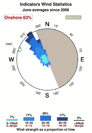
Indicators in Santa Cruz is a sheltered point break that has reasonably consistent surf. Winter is the optimum time of year for surfing here. The best wind direction is from the east northeast with some shelter here from northwest winds. Groundswells more frequent than windswells and the optimum swell angle is from the west northwest. Often Crowded. Overcrowding can even make surfing hazardous.
Indicators Spot Info
| Type: | Rating: | Reliability: | Todays Sea Temp*: |
|---|---|---|---|
| fairly consistent | 14.7°C*ocean temperature recorded from satellite |
Surfing Indicators:
The best conditions reported for surf at Indicators occur when a West-northwest swell combines with an offshore wind direction from the East-northeast.
What's the best time of year to surf Indicators (for consistent clean waves)?
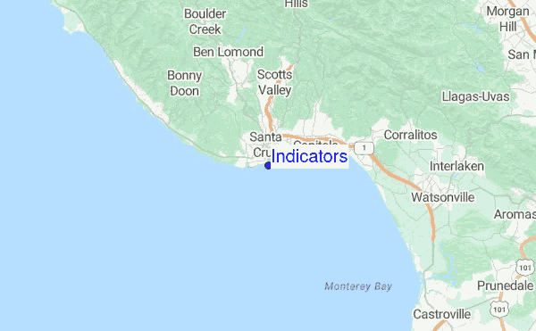
Explore Indicators Location Map
Interactive Indicators surf break location map. View information about nearby surf breaks, their wave consistency and rating compared to other spots in the region. Current swell conditions from local buoys are shown along with live wind speed and direction from nearby weather stations. Click icons on the map for more detail. The closest passenger airport to Indicators is Norman Y Mineta San Jose International Airport (SJC) in USA, 46 km (29 miles) away (directly). The second nearest airport to Indicators is Moffett Federal Afld (Mountain View) Airport (NUQ), also in USA, 52 km (32 miles) away.
- Map Icons:
 Break
Break Live Wave Height (m)
 Live Wind Speed (km/h)
 Surf Rating (10 Max)
 Ocean Swells (m)
- Wind Speed (km/h)
Saturday, 20 June 2026, 04:46 Local Time
| Saturday 20 | ||||
| 2AM | 5AM | 8AM | 11AM | |
| Wave (m) | ||||
| Period (s) | 14 | 14 | 14 | 15 |
| Wind (km/h) | ||||
| Wind State | cross- on |
glass | glass | cross- on |
Tides at Indicators
| NEXT | IS AT (local time) | remaining |
|---|---|---|
| high tide | ||
| low tide |

Swell History at Indicators
Surf stats for Indicators, see the swell variation by month or season on the history page here.

Wind History at Indicators
Wind stats for Indicators, see the variation in direction and stength by month or season on the history page here.
Other Nearby Breaks Closest To:
Discover surf breaks near Indicators. Click below to view there surf guides.
- Steamer Lane-Middle Peak
 Reef
Reef 4.0
4.0
Reliability: very consistent0km away - Steamer Lane-The Point
- Reef
- 4.0
Reliability: very consistent0km away - Steamer Lane-The Slot
- Reef
- 4.0
Reliability: very consistent0km away - Cowells Cove
 Point
Point 1.0
1.0
Reliability: fairly consistent1km away - Mitchell's Cove
- Reef and point
 2.0
2.0
Reliability: fairly consistent1km away
 Nearest