
Danger Surf Guide
Danger in Tel Aviv and South is an exposed breakwater break that only works once in a while. Winter is the favoured time of year for surfing here. Offshore winds are from the east southeast with some shelter here from south southwest winds. The ideal swell direction from the west southwest. The breakwater breaks offer lefts and rights. The quality of the surf isn't affected by the tide. Likely to be crowded if working. Beware of Pollution, crowds.
Danger Spot Info
| Type: | Rating: | Reliability: | Todays Sea Temp*: |
|---|---|---|---|
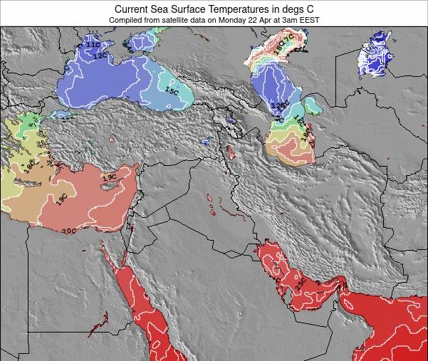
| inconsistent | 25.7°C*ocean temperature recorded from satellite |
Surfing Danger:
The best conditions reported for surf at Danger occur when a West-southwest swell combines with an offshore wind direction from the East-southeast.
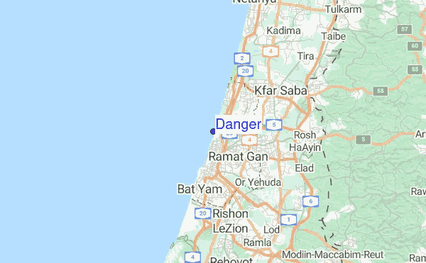
Explore Danger Location Map
Interactive Danger surf break location map. View information about nearby surf breaks, their wave consistency and rating compared to other spots in the region. Current swell conditions from local buoys are shown along with live wind speed and direction from nearby weather stations. Click icons on the map for more detail. The closest passenger airport to Danger is Sde Dov (Tel-aviv) Airport (SDV) in Israel, 1 km (1 miles) away (directly). The second nearest airport to Danger is Ben Gurion (Tel-aviv) Airport (TLV), also in Israel, 15 km (9 miles) away.
- Map Icons:
 Break
Break Live Wave Height (m)
 Live Wind Speed (km/h)
 Surf Rating (10 Max)
 Ocean Swells (m)
- Wind Speed (km/h)
Friday, 19 June 2026, 19:00 Local Time
| Fri | Sat | |||
| 6PM | 9PM | 0AM | 3AM | |
| Wave (m) | ||||
| Period (s) | 5 | 5 | 6 | 6 |
| Wind (km/h) | ||||
| Wind State | on | glass | cross- on |
glass |
Tides at Danger
| NEXT | IS AT (local time) | remaining |
|---|---|---|
| high tide | ||
| low tide |
Swell History at Danger
Surf stats for Danger, see the swell variation by month or season on the history page here.

Wind History at Danger
Wind stats for Danger, see the variation in direction and stength by month or season on the history page here.

Other Nearby Breaks Closest To:
Discover surf breaks near Danger. Click below to view there surf guides.
- Tel Baruch North Beach
 Beach and point
 3.0
3.0
Reliability: fairly consistent1km away - Tel Baruch South Beach
- Beach
 2.0
2.0
Reliability: fairly consistent1km away - Antenot
- Breakwater
- 2.0
Reliability: inconsistent2km away - Ha`Radar or Ha`Basiz
 Sandbar
- 3.0
Reliability: inconsistent2km away - Sheraton-Metzizim
- Beach
- 3.0
Reliability: fairly consistent2km away
 Nearest