

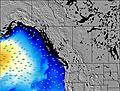
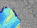
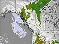
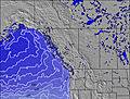
British-Columbia Static Swell and Weather Maps
Four times a day, we generate maps of more than a dozen types. The following five are especially relevant for surfers. Click to zoom and see all forecast periods:

Looking for more info? Here are some more specialized maps for British-Columbia:
- Largest Swell Energy
- Secondary Swell Energy
- Wind Wave Energy
- Sea Temperature Anomaly – i.e. where the current reading deviates from the historical average.
In addition, there are maps of general weather in British-Columbia:
Alternatively, use our animated surf map of British-Columbia where you can toggle all these and more layers. Animated maps also display surf breaks, cities, weather stations and ski resorts' locations!


 Nearest