
Quijote Inn Peak Surf Guide
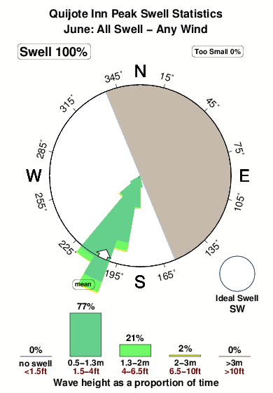
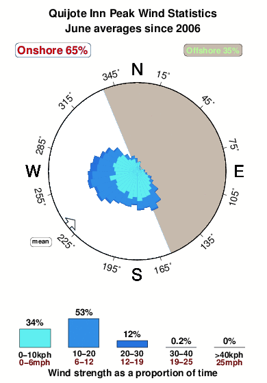
Quijote Inn Peak in Sinaloa is an exposed beach break that has quite reliable surf and can work at any time of the year. Offshore winds blow from the east northeast. Groundswells more frequent than windswells and the ideal swell angle is from the southwest. Waves at the beach tend to peel to the left. Good surf at all stages of the tide. Sometimes crowded. Hazards include .
Quijote Inn Peak Spot Info
| Type: | Rating: | Reliability: | Todays Sea Temp*: |
|---|---|---|---|
| fairly consistent | 29.3°C*ocean temperature recorded from satellite |
Surfing Quijote Inn Peak:
The best conditions reported for surf at Quijote Inn Peak occur when a Southwest swell combines with an offshore wind direction from the East-northeast.
What's the best time of year to surf Quijote Inn Peak (for consistent clean waves)?
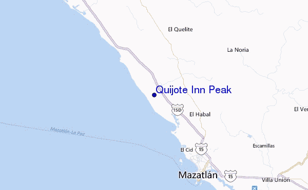
Explore Quijote Inn Peak Location Map
Interactive Quijote Inn Peak surf break location map. View information about nearby surf breaks, their wave consistency and rating compared to other spots in the region. Current swell conditions from local buoys are shown along with live wind speed and direction from nearby weather stations. Click icons on the map for more detail. The nearest passenger airport to Quijote Inn Peak is General Rafael Buelna International (Mazatlan) Airport (MZT) in Mexico, which is 38 km (24 miles) away (directly). The second closest airport to Quijote Inn Peak is Culiacan International Airport (CUL), also in Mexico, 179 km (111 miles) away.
- Map Icons:
 Break
Break Live Wave Height (m)
 Live Wind Speed (km/h)
 Surf Rating (10 Max)
 Ocean Swells (m)
- Wind Speed (km/h)
Tuesday, 9 June 2026, 22:43 Local Time
| Tue | Wed | |||
| 8PM | 11PM | 2AM | 5AM | |
| Wave (m) | ||||
| Period (s) | 17 | 17 | 16 | 16 |
| Wind (km/h) | ||||
| Wind State | on | cross- on |
glass | cross |
Tides at Quijote Inn Peak
| NEXT | IS AT (local time) | remaining |
|---|---|---|
| high tide | ||
| low tide |
Swell History at Quijote Inn Peak
Surf stats for Quijote Inn Peak, see the swell variation by month or season on the history page here.

Wind History at Quijote Inn Peak
Wind stats for Quijote Inn Peak, see the variation in direction and stength by month or season on the history page here.
Other Nearby Breaks Closest To:
Discover surf breaks near Quijote Inn Peak. Click below to view there surf guides.
 Nearest