

Emma Wood State Beach Surf Guide
Emma Wood State Beach in Ventura is a fairly exposed beach and reef break that has quite reliable surf. Summer offers the favoured conditions for surfing. The best wind direction is from the northeast. Tends to receive distant groundswells and the best swell direction is from the southwest. Left and better right hand reef breaks.. Best around mid tide. When the surf is up, crowds are likely Take care of rocks in the line up.
Emma Wood State Beach Spot Info
| Type: | Rating: | Reliability: | Todays Sea Temp*: |
|---|---|---|---|
| fairly consistent | 16.3°C*ocean temperature recorded from satellite |
Surfing Emma Wood State Beach:
The best conditions reported for surf at Emma Wood State Beach occur when a Southwest swell combines with an offshore wind direction from the Northeast.
What's the best time of year to surf Emma Wood State Beach (for consistent clean waves)?
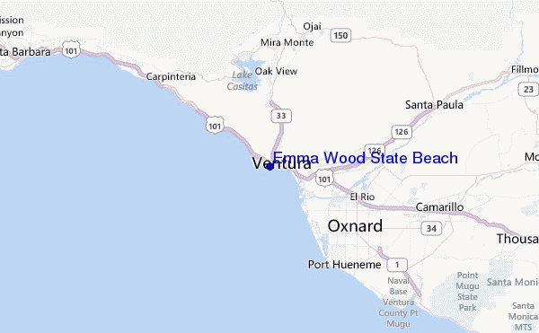
Explore Emma Wood State Beach Location Map
Interactive Emma Wood State Beach surf break location map. View information about nearby surf breaks, their wave consistency and rating compared to other spots in the region. Current swell conditions from local buoys are shown along with live wind speed and direction from nearby weather stations. Click icons on the map for more detail. The closest passenger airport to Emma Wood State Beach is Point Mugu Nas Airport (NTD) in USA, 25 km (16 miles) away (directly). The second nearest airport to Emma Wood State Beach is Burbank Glendale Pasadena Airport (BUR), also in USA, 88 km (55 miles) away.
- Map Icons:
 Break
Break Live Wave Height (m)
 Live Wind Speed (km/h)
 Surf Rating (10 Max)
 Ocean Swells (m)
- Wind Speed (km/h)
Wednesday, 10 June 2026, 05:43 Local Time
| Wednesday 10 | ||||
| 2AM | 5AM | 8AM | 11AM | |
| Wave (m) | ||||
| Period (s) | 18 | 18 | 18 | 17 |
| Wind (km/h) | ||||
| Wind State | glass | glass | glass | on |
Tides at Emma Wood State Beach
| NEXT | IS AT (local time) | remaining |
|---|---|---|
| high tide | ||
| low tide |

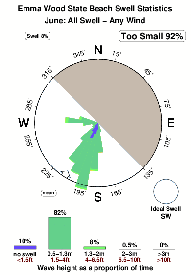
Swell History at Emma Wood State Beach
Surf stats for Emma Wood State Beach, see the swell variation by month or season on the history page here.

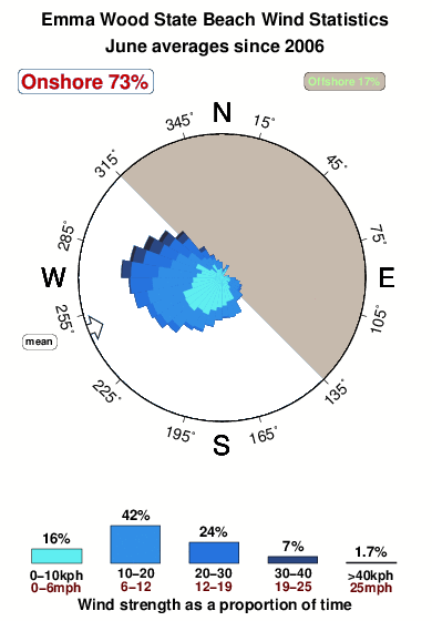
Wind History at Emma Wood State Beach
Wind stats for Emma Wood State Beach, see the variation in direction and stength by month or season on the history page here.
Emma Wood State Beach Reviews:
Interactive Porthcawl Point location map. View nearby buoy information, live wind conditions and surrounding roads, paths and locations to help find new breaks. Click the buoys or wind icon to view more information.
- Overall:
 2.0
2.0 - Quality on a good day:1.5
- Consistency of Surf:
 2.5
2.5 - Difficulty Level:
 1.0
1.0 - Wind and Kite Surfing:2.0
- Crowds:2.0
Other Nearby Breaks Closest To:
Discover surf breaks near Emma Wood State Beach. Click below to view there surf guides.
- Ventura Overhead
 Reef
Reef- 3.0
Reliability: inconsistent1km away - Ventura Point
- Reef and point
- 3.0
Reliability: very consistent1km away - San Buenaventura State Beach
 Beach
Beach- 3.0
Reliability: consistent3km away - New Jetty/South Jetty
- Beach
- 3.0
Reliability: fairly consistent5km away - Santa Clara Rivermouth
- Beach
- 2.0
Reliability: very consistent6km away
 Nearest