- Forecast
- Maps
- Live
- Weather State
- Spot Information
![]() Upload new photo
for Waipapa Bay
|
for another surf break
Upload new photo
for Waipapa Bay
|
for another surf break
| 3 hours earlier |
Peak Waves | Wind | Wind Waves | Swell 1 | Swell 2 | 3 hours later |
|---|---|---|---|---|---|---|
| 8 s | off | 5 s | 9 s | 6 s |
Open ocean wave model on 15 November at 12 pm
Forecast wind and swell just offshore from Waipapa Bay around the time the photo was taken
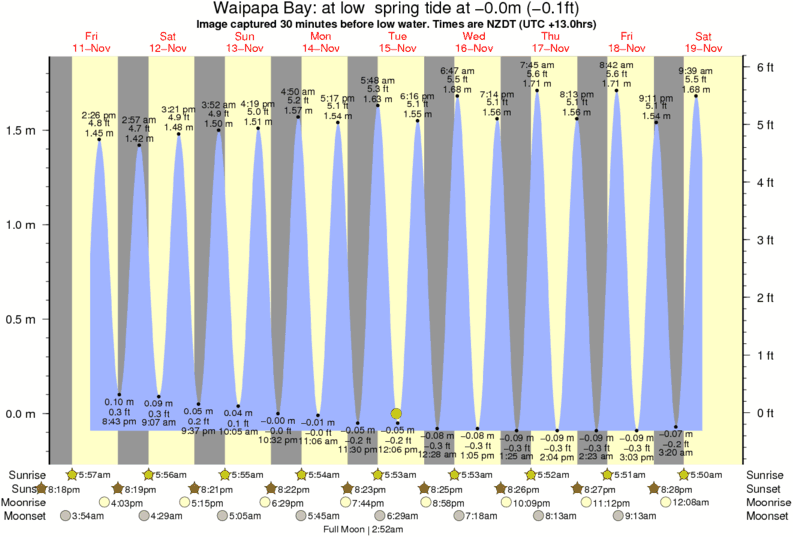
Image captured 30 minutes before low water (at low spring tide). Tide height was -0.0m (-0.1 ft). Range 1.80m (5.9 ft). Toggle tide graph

Waipapa Bay Surf Photo: 'Waipapa Bay area after the 7.8 Kaikoura Earthquake' by Rob Davies
Just look at the new fault scarp, about 2m high! Uploaded so this site can figure where the tide was at the time of this image. That way we will get some idea of how much uplift there is in the Waipapa and Clarence areas. First impressions for the Kaikoura breaks is that high water is now about where low water was at Kahutara and with that effect increasing as we go north to about Clarence and Kekerengu. Some breaks may have been destroyed but others may have improved and entirely new ones created.
 Nearest