
Malindi Bay Surf Guide
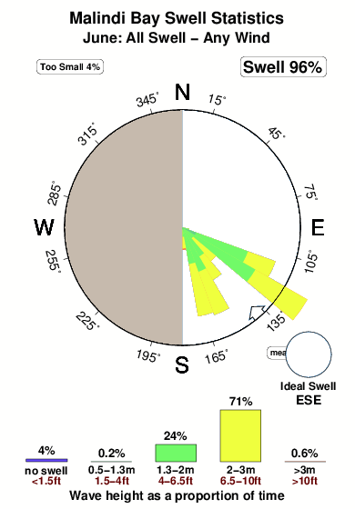
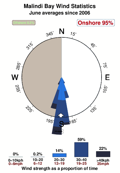
Malindi Bay in Kenya is an exposed beach break that is usually a safe bet. Offshore winds blow from the west. Handles onshore winds better than most spots The ideal swell direction from the east southeast. Waves at the beach break both left and right. Good surf at all stages of the tide. Rarely crowded here. Watch out for - Rips / undertow - Pollution.
Malindi Bay Spot Info
| Type: | Rating: | Reliability: | Todays Sea Temp*: |
|---|---|---|---|
| very consistent | 27.1°C*ocean temperature recorded from satellite |
Surfing Malindi Bay:
The best conditions reported for surf at Malindi Bay occur when a East-southeast swell combines with an offshore wind direction from the West.
What's the best time of year to surf Malindi Bay (for consistent clean waves)?
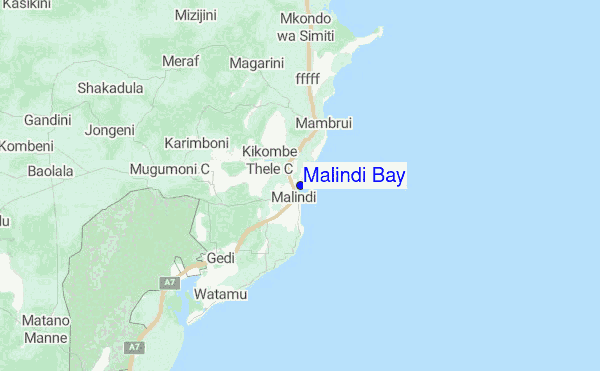
Explore Malindi Bay Location Map
Interactive Malindi Bay surf break location map. View information about nearby surf breaks, their wave consistency and rating compared to other spots in the region. Current swell conditions from local buoys are shown along with live wind speed and direction from nearby weather stations. Click icons on the map for more detail. The closest passenger airport to Malindi Bay is Malindi Airport (MYD) in Kenya, which is 4 km (2 miles) away (directly). The second nearest airport to Malindi Bay is Moi International (Mombasa) Airport (MBA), also in Kenya, 110 km (68 miles) away.
- Map Icons:
 Break
Break Live Wave Height (m)
 Live Wind Speed (km/h)
 Surf Rating (10 Max)
 Ocean Swells (m)
- Wind Speed (km/h)
Monday, 22 June 2026, 07:05 Local Time
| Monday 22 | ||||
| 6AM | 9AM | 12PM | 3PM | |
| Wave (m) | ||||
| Period (s) | 7 | 7 | 7 | 7 |
| Wind (km/h) | ||||
| Wind State | cross | cross | cross | cross |
Tides at Malindi Bay
| NEXT | IS AT (local time) | remaining |
|---|---|---|
| high tide | ||
| low tide |
Swell History at Malindi Bay
Surf stats for Malindi Bay, see the swell variation by month or season on the history page here.

Wind History at Malindi Bay
Wind stats for Malindi Bay, see the variation in direction and stength by month or season on the history page here.
Malindi Bay Reviews:
Interactive Porthcawl Point location map. View nearby buoy information, live wind conditions and surrounding roads, paths and locations to help find new breaks. Click the buoys or wind icon to view more information.
- Overall:
 1.0
1.0 - Quality on a good day:
 1.8
1.8 - Consistency of Surf:
 2.5
2.5 - Difficulty Level:1.5
- Wind and Kite Surfing:2.3
- Crowds:2.8
Other Nearby Breaks Closest To:
Discover surf breaks near Malindi Bay. Click below to view there surf guides.
 Nearest