

Surf Forecasts:

Lagart Point surf forecast from 3 Jul 2026:
- Best quality surf: Friday 3 Jul, 1PM (local time) - 4ft (1.2m), 16s period, SSW swell with offshore winds.
- Most powerful swell: Tuesday 7 Jul, 1PM (local time) - 4.5ft (1.3m), 18s period, SSW swell with 983 kJ wave energy.
- Next surfable swell (1★+): Friday 3 Jul, 1AM (local time) - 3.5ft (1.0m), 17s period with S swell.
Best Forecast Surf Conditions for Lagart Point this week:
The surf forecast for Lagart Point over the next 16 days: The first swell (rated 1 star or higher) is forecast to arrive on Friday (Jul 03) at 1AM. The primary swell is predicted to be 1.0m and 17s period with a secondary swell of 0.4m and 6s. The wind is predicted to be offshore as the swell arrives.
The most powerful waves expected at Lagart Point in the next 16 days are 1.3m 18s and forecast to arrive on Tuesday (Jul 07) at 1PM. Winds are predicted to be cross-offshore at the time the swell arrives. The largest open ocean swell (not directed at the beach) is 0.6m 3s period and expected on Monday (Jul 06) at 1AM.
| Wave Type | Time (EST) & Date | Wave Height & Period |
|---|---|---|
| Next good surf (1 star+) | 1AM (Fri 3rd Jul) | 3.5ft (1.0m) 17s |
| Best Surf | 1PM (Fri 3rd Jul) | 4ft (1.2m) 16s |
| Most Powerful | 1PM (Tue 7th Jul) | 4.5ft (1.3m) 18s |
Table - best surf conditions forecast for Lagart Point over the next 16 days.
Updates in hr min s Forecast update imminent
Alright folks, Rusty here. Let's talk about what’s heading our way at Lagart Point. The water is sitting at a balmy 85°, which is a touch warmer than normal for this time of year – not a major anomaly, but enough to notice when you're sitting out there waiting.
We've got a solid run of surf lined up, kicking off this Thursday, July 2nd. The afternoon sees a clean, 3ft S swell arriving with a very long 15-second period. The wind is a light cross-offshore breeze at 6 mph, and the water is glassy. The energy is moderate (671), and honestly, conditions look fantastic. This points to quality, lined-up waves perfect for the beginner-friendly point setup.
That swell holds through Friday, July 3rd, and it might actually be the pick of the week. It bumps up slightly to 4ft from the S, still with that excellent 16-second period. Friday morning has a light offshore wind, but the afternoon is the real standout here: glassy conditions with the wind dropping to nearly nothing (3 mph). The wave energy stays strong in the mid-600s range. This is prime time for a long session with clean, peeling walls.
Saturday, July 4th, the swell drops back to 3ft, and while the period is still a long 15 seconds, the winds get a bit messy with a cross-shore and some rain around. The quality fades a bit, but there are still waves to be had.
Into the second week, the consistency is there, but the quality becomes more of a mixed bag. There are waves on offer right through, with the swell direction swinging to the SSW, but the period and energy start to fluctuate. A highlight in this period looks to be Saturday, July 11th. The swell is a workable 3ft from the SSW with a 16-second period, and we get another window of glassy conditions. It’s a smaller, cleaner window compared to the first weekend, but for a patient surfer, it'll offer up some nice, clean lines. The energy is moderate (521).
Sunday, July 12th also offers a clean run of small 3ft SSW swell with cross-offshore winds, making for a decent morning and afternoon session.
Overall, the real standouts are undoubtedly the Thursday afternoon and Friday afternoon of the first week. After that, the swell remains surfable but the quality drops off, with more marginal conditions and a few periods of poor surf. There are no massive, empty days to worry about, and the crowds are described as "sometimes" here, so you might have a few friends out on the best days, but likely not a circus.
Stay stoked.
Rusty
Short Range ForecastHeavy rain (total 174mm), heaviest during Thu night. Warm (max 29°C on Thu afternoon, min 24°C on Fri morning). Wind will be generally light. | Days 5-7 Weather SummaryModerate rain (total 11mm), heaviest on Sun night. Warm (max 30°C on Wed morning, min 27°C on Sun afternoon). Wind will be generally light. | ||||||||||||||||||||
Thu 2 | Friday 3 | Saturday 4 | Sunday 5 | Monday 6 | Tuesday 7 | Wednesday 8 | |||||||||||||||
PM | Night | AM | PM | Night | AM | PM | Night | AM | PM | Night | AM | PM | Night | AM | PM | Night | AM | PM | Night | AM | |
Swell Height Map |  |  |  | 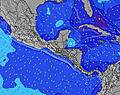 | 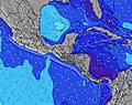 | 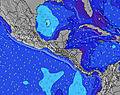 | 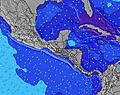 | 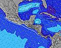 | |||||||||||||
Wave Height (m) Direction Period (s) | S 15 | S 17 | S 16 | S 16 | S 15 | S 15 | S 15 | S 14 | SSW 14 | SSW 14 | SSW 21 | SSW 21 | SSW 20 | SSW 19 | SSW 18 | SSW 18 | SSW 17 | SSW 16 | SSW 16 | SSW 16 | SSW 15 |
Wave Graph | |||||||||||||||||||||
441 | 596 | 627 | 643 | 453 | 484 | 435 | 429 | 327 | 313 | 260 | 176 | 432 | 428 | 565 | 983 | 939 | 597 | 547 | 527 | 408 | |
Wind (km/h) | |||||||||||||||||||||
Wind State on-shore cross-onshore cross-shore cross-offshore off-shore glassy | cross-off | off | off | glassy | cross-off | cross | cross-off | off | cross-off | cross-off | off | cross-off | cross | cross-off | cross-off | cross | cross-off | cross-off | cross | off | cross-off |
High Tide | 5:24PM3.26m | 5:57AM3.26m | 6:01PM3.22m | 6:33AM3.27m | 6:39PM3.16m | 7:09AM3.27m | 7:18PM3.08m | 7:47AM3.26m | 8:01PM2.99m | 8:29AM3.25m | 8:51PM2.91m | 9:17AM3.23m | 9:48PM2.86m | 10:13AM3.22m | |||||||
Low Tide | 11:40PM0.47m | 12:00PM0.81m | 00:16AM0.53m | 12:38PM0.83m | 00:51AM0.60m | 1:18PM0.85m | 1:28AM0.69m | 2:00PM0.86m | 2:08AM0.79m | 2:48PM0.87m | 2:55AM0.87m | 3:42PM0.85m | 3:50AM0.94m | ||||||||
— | — | 6:07 | — | — | 6:07 | — | — | 6:07 | — | — | 6:07 | — | — | 6:07 | — | — | 6:07 | — | — | 6:09 | |
6:39 | — | — | 6:39 | — | — | 6:39 | — | — | 6:39 | — | — | 6:40 | — | — | 6:40 | — | — | 6:40 | — | 6:40 | |
mm | 5 | 78 | 74 | 2 | 2 | 6 | 5 | — | 2 | — | 3 | — | — | — | — | — | 5 | 3 | 3 | 20 | 4 |
Temp °C | 29 | 28 | 25 | 27 | 27 | 26 | 26 | 27 | 28 | 28 | 27 | 28 | 29 | 28 | 29 | 29 | 28 | 30 | 30 | 29 | 29 |
Feels °C | 33 | 32 | 28 | 32 | 31 | 30 | 28 | 29 | 30 | 31 | 30 | 31 | 32 | 31 | 31 | 32 | 30 | 32 | 34 | 34 | 32 |
Swell 1 Height (m) Direction Period (s) | S 15 | S 17 | S 16 | S 16 | S 15 | S 15 | S 15 | S 14 | SSW 14 | SSW 14 | SSW 13 | S 13 | SSW 14 | SSW 19 | SSW 18 | SSW 18 | SSW 17 | SSW 16 | SSW 16 | SSW 16 | SSW 15 |
441 | 596 | 627 | 643 | 453 | 484 | 435 | 429 | 327 | 313 | 173 | 123 | 269 | 428 | 565 | 983 | 939 | 597 | 547 | 527 | 408 | |
Swell 2 Height (m) Direction Period (s) | S 18 | SSW 6 | SW 6 | SSW 6 | S 6 | S 6 | S 6 | SSW 18 | SSW 18 | SSW 9 | SSW 16 | SSW 16 | SSW 20 | SSW 14 | SSW 14 | — | — | SSW 10 | SSW 10 | S 10 | SSW 10 |
230 | 12 | 18 | 16 | 20 | 19 | 18 | 123 | 32 | 26 | 193 | 144 | 432 | 215 | 213 | — | — | 33 | 36 | 49 | 18 | |
Swell 3 Height (m) Direction Period (s) | — | S 11 | — | SW 21 | — | SSW 20 | SW 20 | S 26 | SSW 24 | SSW 24 | SSW 21 | SSW 21 | S 9 | — | — | — | — | — | NE 4 | — | NNE 4 |
— | 20 | — | 18 | — | 75 | 61 | 13 | 54 | 54 | 260 | 176 | 24 | — | — | — | — | — | 4 | — | 3 | |
Wind waves Height (m) Direction Period (s) | — | — | — | — | — | — | — | — | — | — | N 3 | NNE 4 | — | N 3 | — | — | N 4 | NNE 4 | — | N 4 | N 4 |
— | — | — | — | — | — | — | — | — | — | 8 | 10 | — | 5 | — | — | 9 | 5 | — | 7 | 7 | |
Nearest Offshore or Glassy | |||||||||||||||||||||
Distance (km) | 0 | 0 | 0 | 0 | 0 | 9 | 0 | 0 | 48 | 0 | 0 | 0 | 9 | 9 | 9 | 9 | 9 | 9 | 106 | 0 | 0 |
Best forecast wave conditions in Gulf of Panama | |||||||||||||||||||||
Best forecast wave conditions in Panama | |||||||||||||||||||||
Header Global | |||||||||||||||||||||
- Map Icons:
 Break
Break Live Wave Height (m)
 Live Wind Speed (km/h)
 Surf Rating (10 Max)
 Ocean Swells (m)
- Wind Speed (km/h)


FREE! Surf-Forecast.com widget for your website
The surf report / weather widget below is available to embed on third party websites free of charge and provides a summary of our Lagart Point surf forecast. Simply grab the html code snippet that we provide and paste it into your own site. You can choose your preferred language and metric/imperial units for the surf forecast feed to suit users of your site. Click here to get the code.
Information about the Lagart Point Surf forecast
The above surf forecast table for Lagart Point provides essential information for determining whether the surfing conditions will be good over the next 16 days. A general guide to surfing at Lagart Point can be found by selecting the local surf guide option on the grey menu. Our Lagart Point surf forecast is unique since it includes wave energy (power) that defines the real feel of the surf rather than just the height or the period. If you surf the same spot (Lagart Point) regularly then make a mental note of the wave energy from the surf forecast table each time you go. Very soon you may start to choose your surf days based on the wave energy alone combined with our forecast of favourable offshore wind conditions. Our star ratings will help here and of course you will also find the usual wave height and period predictions on our surf forecasts as well as a full break down of the swell components under our advanced users option (to reveal that, click the little Einstein character under the tide times).
Further information to help with frequently asked questions about our surf forecast for Lagart Point may be found under the help tab on the top menu and also by moving your mouse over the question marks on the surf forecast table itself. Please always bear in mind that the forecast is for near-shore open water and local factors at each surf break influence the actual breaking wave height, such as the beach / reef profile, water depths offshore and shelter.
 Nearest