

Surf Forecasts:

La Bellaca surf forecast from 2 Aug 2026:
- Best quality surf: Friday 7 Aug, 4AM (local time) - 2ft (0.6m), 12s period, WSW swell with glassy winds.
- Most powerful swell: Monday 3 Aug, 7AM (local time) - 2.5ft (0.8m), 13s period, SW swell with 212 kJ wave energy.
- Next surfable swell (1★+): Tuesday 4 Aug, 10AM (local time) - 1.5ft (0.4m), 12s period with SW swell.
Best Forecast Surf Conditions for La Bellaca this week:
The surf forecast for La Bellaca over the next 16 days: The first swell (rated 1 star or higher) is forecast to arrive on Tuesday (Aug 04) at 10AM. The primary swell is predicted to be 0.5m and 9s period with a secondary swell of 0.4m and 12s. The wind is predicted to be glassy as the swell arrives.
The most powerful waves expected at La Bellaca in the next 16 days are 0.8m 13s and forecast to arrive on Monday (Aug 03) at 7AM. Winds are predicted to be cross-shore at the time the swell arrives.
| Wave Type | Time (-05) & Date | Wave Height & Period |
|---|---|---|
| Next good surf (1 star+) | 10AM (Tue 4th Aug) | 1.5ft (0.4m) 12s |
| Best Surf | 4AM (Fri 7th Aug) | 2ft (0.6m) 12s |
| Most Powerful | 7AM (Mon 3rd Aug) | 2.5ft (0.8m) 13s |
Table - best surf conditions forecast for La Bellaca over the next 16 days.
The Lowdown
Alright folks, Rusty here. Let’s get into it.
Overall, this is a quiet stretch for the region. We’re looking at a long wait for anything decent, with a lot of small, weak, and onshore days ahead. There’s one standout morning that’s worth circling on the calendar, and a couple of possible windows later on, but don’t hold your breath. The water temp is about average for this time of year.
First up, the only real shining moment across the whole 16 days lands on Friday, August 7th, in the morning. La Bellaca is a point break that’s exposed to a SW swell, and it’s inconsistent, meaning it doesn’t fire often. But when it does, it can be special. That morning we’ve got a 2 ft SW groundswell with a very long period of 16 seconds, packing a moderate energy punch (226). The wind is glassy, dead calm, and it’s a clear morning. That’s clean, groomed, and offers the best chance of a proper wave. The swell is small, but on a point break, that long-period energy will wrap in nicely. This is your best bet, but remember, it’s an inconsistent spot, so patience is key.
Before that, the run-up is mostly poor. Sunday, August 2nd, has a tiny 2 ft SW swell, but the cross-on wind and marginal conditions make it a write-off. Monday the 3rd through Thursday the 6th is a wasteland of small, weak, onshore slop. The only small glimmers are early Tuesday and Wednesday mornings, with glassy conditions but tiny 1 ft-2 ft SW swells and weak energy (85). Surfable, but ordinary.
After the Friday highlight, things go back into the gutter. The weekend of the 8th and 9th sees onshore winds and poor surf. The following week is a long, flat slog with nothing rideable until Friday, August 14th, in the morning. That morning at La Bellaca we see a 2 ft WSW groundswell, period of 17 seconds, with glassy wind and moderate energy (210). Again, small, but clean and promising for a point break that can handle the long period. The afternoon gets ruined by the onshore, as usual.
The last potential look is Monday, August 17th, in the morning, with a 2 ft SW swell, 16-second period, and moderate energy (324), but the wind is light onshore, making it marginal. It’s a chance, but not a certainty.
In short, the only real standout is that Friday, August 7th, morning glass-off. The rest is a long, quiet wait. Keep your expectations low, and if you can, paddle out on that Friday for the cleanest you’ll see.
Rusty.
Short Range ForecastMostly dry. Warm (max 27°C on Mon morning, min 23°C on Mon night). Wind will be generally light. | Days 4-6 Weather SummaryMostly dry. Warm (max 26°C on Wed morning, min 24°C on Tue night). Wind will be generally light. | ||||||||||||||||||||
Sunday 2 | Monday 3 | Tuesday 4 | Wednesday 5 | Thursday 6 | Friday 7 | Saturday 8 | |||||||||||||||
AM | PM | Night | AM | PM | Night | AM | PM | Night | AM | PM | Night | AM | PM | Night | AM | PM | Night | AM | PM | Night | |
Swell Height Map | 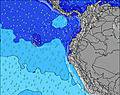 | 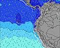 | 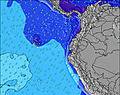 | 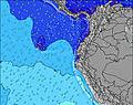 | 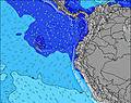 | 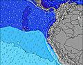 | 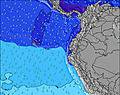 | ||||||||||||||
Wave Height (m) Direction Period (s) | SW 12 | SW 11 | SW 11 | SW 10 | WSW 13 | SW 12 | SW 12 | SW 12 | SW 12 | SW 13 | SW 12 | SW 14 | SW 13 | SW 13 | SW 18 | SW 16 | SW 16 | SW 15 | SW 14 | SW 14 | SW 13 |
Wave Graph | |||||||||||||||||||||
134 | 202 | 168 | 68 | 66 | 39 | 38 | 36 | 35 | 42 | 37 | 64 | 140 | 84 | 108 | 127 | 124 | 107 | 164 | 160 | 84 | |
Wind (km/h) | |||||||||||||||||||||
Wind State on-shore cross-onshore cross-shore cross-offshore off-shore glassy | cross-on | on | cross-on | cross-on | on | cross-on | glassy | on | cross-on | glassy | on | cross-on | cross-on | on | cross-on | glassy | on | cross-on | cross-on | on | cross-on |
High Tide | 6:03AM2.68m | 6:13PM2.49m | 6:36AM2.67m | 6:52PM2.44m | 7:12AM2.62m | 7:34PM2.36m | 7:54AM2.55m | 8:23PM2.27m | 8:42AM2.46m | 9:22PM2.19m | 9:42AM2.36m | 10:34PM2.14m | 10:54AM2.31m | 11:54PM2.18m | |||||||
Low Tide | 12:13PM0.47m | 00:20AM0.38m | 12:50PM0.47m | 00:56AM0.46m | 1:30PM0.49m | 1:37AM0.55m | 2:15PM0.53m | 2:25AM0.66m | 3:09PM0.57m | 3:24AM0.76m | 4:15PM0.60m | 4:37AM0.83m | 5:30PM0.58m | ||||||||
6:24 | — | — | 6:24 | — | — | 6:24 | — | — | 6:24 | — | — | 6:24 | — | — | 6:24 | — | — | 6:24 | — | — | |
— | 6:30 | — | — | 6:30 | — | — | 6:30 | — | — | 6:30 | — | — | 6:30 | — | — | 6:30 | — | — | 6:30 | — | |
mm | — | — | — | — | — | — | — | — | — | — | — | — | — | — | — | — | — | — | — | — | — |
Temp °C | 26 | 26 | 24 | 27 | 25 | 24 | 27 | 26 | 24 | 26 | 26 | 25 | 26 | 26 | 25 | 26 | 26 | 25 | 26 | 26 | 25 |
Feels °C | 27 | 26 | 25 | 28 | 25 | 26 | 28 | 27 | 25 | 27 | 27 | 27 | 29 | 27 | 27 | 29 | 27 | 27 | 28 | 26 | 27 |
Swell 1 Height (m) Direction Period (s) | WSW 15 | WSW 14 | WSW 13 | WSW 13 | WSW 13 | SW 10 | SW 9 | SW 12 | SW 12 | SW 13 | SW 12 | SW 14 | SW 13 | SW 13 | SW 12 | WSW 12 | SW 16 | SW 15 | SW 14 | SW 14 | SW 13 |
84 | 81 | 70 | 68 | 66 | 24 | 38 | 36 | 35 | 42 | 37 | 64 | 140 | 84 | 73 | 96 | 124 | 107 | 164 | 160 | 84 | |
Swell 2 Height (m) Direction Period (s) | WNW 11 | WNW 11 | WNW 11 | WNW 11 | SW 10 | SW 12 | SW 12 | WNW 10 | WNW 10 | WSW 11 | WNW 9 | WNW 9 | SW 19 | SW 18 | SW 18 | SW 16 | SW 12 | SW 12 | SW 10 | NW 9 | NW 8 |
23 | 25 | 22 | 25 | 16 | 39 | 37 | 10 | 10 | 11 | 8 | 8 | 57 | 50 | 108 | 127 | 71 | 68 | 16 | 3 | 3 | |
Swell 3 Height (m) Direction Period (s) | — | SW 18 | — | SW 16 | WNW 11 | WNW 11 | WNW 10 | SW 15 | — | WNW 10 | SW 15 | SW 20 | NW 9 | NW 9 | NW 9 | NW 8 | NW 10 | NW 9 | NW 9 | — | SW 18 |
— | 12 | — | 10 | 25 | 11 | 10 | 9 | — | 9 | 9 | 15 | 3 | 3 | 3 | 3 | 4 | 3 | 3 | — | 12 | |
Wind waves Height (m) Direction Period (s) | SW 12 | SW 11 | SW 11 | SW 10 | SW 4 | WSW 4 | — | SW 3 | SW 8 | SW 8 | SW 4 | SW 11 | — | WSW 3 | WSW 4 | — | WSW 3 | SW 3 | SW 4 | SW 4 | SW 6 |
134 | 202 | 168 | 61 | 15 | 6 | — | 8 | 31 | 23 | 15 | 57 | — | 8 | 3 | — | 1 | 2 | 6 | 14 | 11 | |
Nearest Offshore or Glassy | |||||||||||||||||||||
Distance (km) | 44 | 876 | 180 | 47 | 883 | 47 | 0 | 1118 | 449 | 0 | 841 | 182 | 44 | 182 | 44 | 0 | 901 | 173 | 44 | 876 | 44 |
Best forecast wave conditions in Manabi | |||||||||||||||||||||
Best forecast wave conditions in Ecuador | |||||||||||||||||||||
Header Global | |||||||||||||||||||||
- Map Icons:
 Break
Break Live Wave Height (m)
 Live Wind Speed (km/h)
 Surf Rating (10 Max)
 Ocean Swells (m)
- Wind Speed (km/h)
Latest Updates


FREE! Surf-Forecast.com widget for your website
The surf report / weather widget below is available to embed on third party websites free of charge and provides a summary of our La Bellaca surf forecast. Simply grab the html code snippet that we provide and paste it into your own site. You can choose your preferred language and metric/imperial units for the surf forecast feed to suit users of your site. Click here to get the code.
Information about the La Bellaca Surf forecast
The above surf forecast table for La Bellaca provides essential information for determining whether the surfing conditions will be good over the next 16 days. A general guide to surfing at La Bellaca can be found by selecting the local surf guide option on the grey menu. Our La Bellaca surf forecast is unique since it includes wave energy (power) that defines the real feel of the surf rather than just the height or the period. If you surf the same spot (La Bellaca) regularly then make a mental note of the wave energy from the surf forecast table each time you go. Very soon you may start to choose your surf days based on the wave energy alone combined with our forecast of favourable offshore wind conditions. Our star ratings will help here and of course you will also find the usual wave height and period predictions on our surf forecasts as well as a full break down of the swell components under our advanced users option (to reveal that, click the little Einstein character under the tide times).
Further information to help with frequently asked questions about our surf forecast for La Bellaca may be found under the help tab on the top menu and also by moving your mouse over the question marks on the surf forecast table itself. Please always bear in mind that the forecast is for near-shore open water and local factors at each surf break influence the actual breaking wave height, such as the beach / reef profile, water depths offshore and shelter.
La Bellaca is 6 km (4 miles) from Bahia de Caraques. If you plan a holiday in Manabi, look for hotels and other accommodation in Bahia de Caraques. Bahia de Caraques has rooms for a wide range of budgets as well as car hire and transport links.
 Nearest