
Bahia Tortugas (Turtle Bay) Surf Guide
Bahia Tortugas (Turtle Bay) in Baja Sur is a reasonably exposed beach break that has reasonably consistent surf and can work at any time of the year. Offshore winds blow from the northeast. Groundswells more frequent than windswells and the best swell direction is from the southwest. The beach break offers both left and right hand waves. Rarely crowded here. Beware of rips, sharks and rocks.
Bahia Tortugas (Turtle Bay) Spot Info
| Type: | Rating: | Reliability: | Todays Sea Temp*: |
|---|---|---|---|
| fairly consistent | 18.8°C*ocean temperature recorded from satellite |
Surfing Bahia Tortugas (Turtle Bay):
The best conditions reported for surf at Bahia Tortugas (Turtle Bay) occur when a Southwest swell combines with an offshore wind direction from the Northeast.
What's the best time of year to surf Bahia Tortugas (Turtle Bay) (for consistent clean waves)?
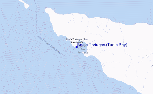
Explore Bahia Tortugas (Turtle Bay) Location Map
Interactive Bahia Tortugas (Turtle Bay) surf break location map. View information about nearby surf breaks, their wave consistency and rating compared to other spots in the region. Current swell conditions from local buoys are shown along with live wind speed and direction from nearby weather stations. Click icons on the map for more detail. The nearest passenger airport to Bahia Tortugas (Turtle Bay) is General Jose Maria Yanez International (Guaymas) Airport (GYM) in Mexico, which is 392 km (243 miles) away (directly). The second closest airport to Bahia Tortugas (Turtle Bay) is Loreto International Airport (LTO), also in Mexico, 399 km (248 miles) away.
- Map Icons:
 Break
Break Live Wave Height (m)
 Live Wind Speed (km/h)
 Surf Rating (10 Max)
 Ocean Swells (m)
- Wind Speed (km/h)
Friday, 19 June 2026, 12:06 Local Time
| Friday 19 | ||||
| 8AM | 11AM | 2PM | 5PM | |
| Wave (m) | ||||
| Period (s) | 15 | 15 | 15 | 15 |
| Wind (km/h) | ||||
| Wind State | cross- off |
cross- off |
cross- off |
cross- off |
Tides at Bahia Tortugas (Turtle Bay)
| NEXT | IS AT (local time) | remaining |
|---|---|---|
| high tide | ||
| low tide |
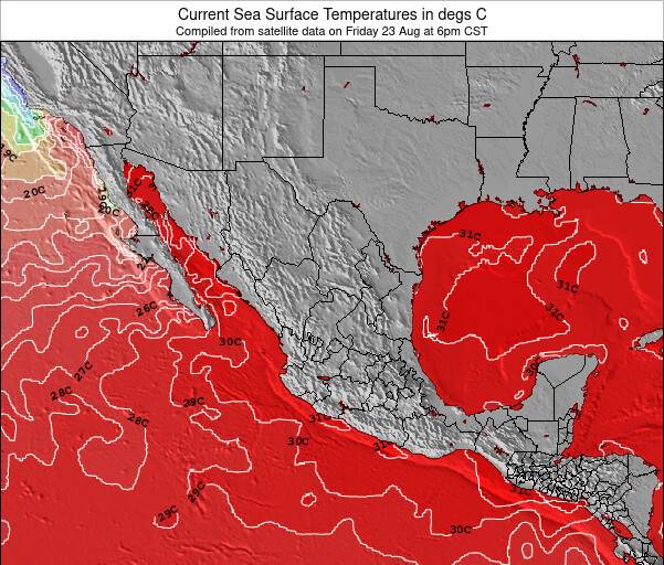
Bahia Tortugas (Turtle Bay) Sea Temperature
The water temperature (18.8 °C) at Bahia Tortugas (Turtle Bay) is relatively warm. If the sun does come out as forecast, it should feel warm enough to surf in a summer wetsuit. Effective air temperature of 19.0 °C.
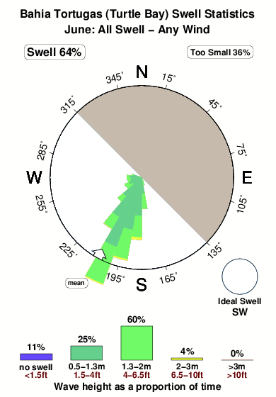
Swell History at Bahia Tortugas (Turtle Bay)
Surf stats for Bahia Tortugas (Turtle Bay), see the swell variation by month or season on the history page here.

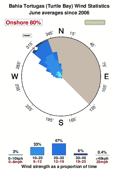
Wind History at Bahia Tortugas (Turtle Bay)
Wind stats for Bahia Tortugas (Turtle Bay), see the variation in direction and stength by month or season on the history page here.
Bahia Tortugas (Turtle Bay) Reviews:
Interactive Porthcawl Point location map. View nearby buoy information, live wind conditions and surrounding roads, paths and locations to help find new breaks. Click the buoys or wind icon to view more information.
- Overall:
 1.0
1.0 - Quality on a good day:
 3.7
3.7 - Consistency of Surf:4.3
- Difficulty Level:4.3
- Wind and Kite Surfing:
 4.7
4.7 - Crowds:4.5
I am coming by boat and want to know if there is fuel there
John”
Other Nearby Breaks Closest To:
Discover surf breaks near Bahia Tortugas (Turtle Bay). Click below to view there surf guides.
- Open Doors (Isla Natividad)
 Beach
Beach- 1.0
Reliability: fairly consistent34km away - Playa Elefante (Isla Cedros)
- Beach
- 1.0
Reliability: fairly consistent68km away - Asuncion Bay
- Beach and reef
- 1.0
Reliability: fairly consistent85km away - San Hipolito
- Beach and reef
- 1.0
Reliability: fairly consistent116km away - Millers Landing
- Beach and point
- 1.0
Reliability: consistent122km away
 Nearest