
Al Gal Surf Guide
Al Gal in Tel Aviv and South is an exposed beach break that usually has waves. Offshore winds are from the east and there is no shelter here from cross shore breezes. Able to handle light onshore wind Most of the surf comes fis in the form of windswells and the ideal wave angle is from the west. The beach break offers both left and right hand waves. The quality of the surf isn't affected by the tide. Likely to be crowded if working. Overcrowding can even make surfing hazardous.
Al Gal Spot Info
| Type: | Rating: | Reliability: | Todays Sea Temp*: |
|---|---|---|---|
| consistent | 29.2°C*ocean temperature recorded from satellite |
Surfing Al Gal:
The best conditions reported for surf at Al Gal occur when a West swell combines with an offshore wind direction from the East.
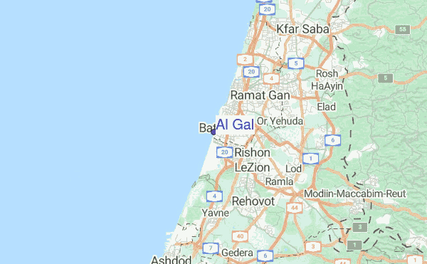
Explore Al Gal Location Map
Interactive Al Gal surf break location map. View information about nearby surf breaks, their wave consistency and rating compared to other spots in the region. Current swell conditions from local buoys are shown along with live wind speed and direction from nearby weather stations. Click icons on the map for more detail. The closest passenger airport to Al Gal is Sde Dov (Tel-aviv) Airport (SDV) in Israel, 12 km (7 miles) away (directly). The second nearest airport to Al Gal is Ben Gurion (Tel-aviv) Airport (TLV), also in Israel, 13 km (8 miles) away.
- Map Icons:
 Break
Break Live Wave Height (m)
 Live Wind Speed (km/h)
 Surf Rating (10 Max)
 Ocean Swells (m)
- Wind Speed (km/h)
Monday, 3 August 2026, 19:10 Local Time
| Mon | Tue | |||
| 6PM | 9PM | 0AM | 3AM | |
| Wave (m) | ||||
| Period (s) | 5 | 4 | 4 | 4 |
| Wind (km/h) | ||||
| Wind State | cross- on |
cross | cross | cross |
Tides at Al Gal
| NEXT | IS AT (local time) | remaining |
|---|---|---|
| high tide | ||
| low tide |
Swell History at Al Gal
Surf stats for Al Gal, see the swell variation by month or season on the history page here.


Wind History at Al Gal
Wind stats for Al Gal, see the variation in direction and stength by month or season on the history page here.

Other Nearby Breaks Closest To:
Discover surf breaks near Al Gal. Click below to view there surf guides.
 Nearest