- Forecast
- Maps
- Live
- Weather State
- Spot Information
Keel Surf Forecast
/ Mayo and Achill Island (14 surf breaks) /Surf Forecasts:


Keel surfForecast / Mayo and Achill Island / Ireland
Forecast update in hr min s Forecast update imminent
Keel surf forecast is for near shore open water. Breaking waves will often be smaller at less exposed spots.
Today's Keel sea temperature is
16.9° C
(Which is 1.8°C warmer than normal for this time of year)How big are the waves at Keel today?
The current surf forecast for Keel at 8AM is: 3.0m 10s primary swell from a West-northwest direction (forecast issued at 06:00am August 29). The wind direction is predicted to be cross-onshore.
| Time (IST) & Date | Wave Height | Wave Period |
|---|---|---|
| Morning (29 Aug) | 10ft (3.0m) | 10s |
| Afternoon (29 Aug) | 10ft (3.0m) | 9s |
| Evening (29 Aug) | 8ft (2.5m) | 9s |
Table - waves today at Keel. (Swell directed towards the surf break)
Updates in hr min s Forecast update imminent
Friday 29 | Saturday 30 | Sunday 31 | Mon 01 | |||||||||||||||||||||
| 4 AM | 7 AM | 10 AM | 1 PM | 4 PM | 7 PM | 10 PM | 1 AM | 4 AM | 7 AM | 10 AM | 1 PM | 4 PM | 7 PM | 10 PM | 1 AM | 4 AM | 7 AM | 10 AM | 1 PM | 4 PM | 7 PM | 10 PM | 1 AM | |
Rating (10 max) | ||||||||||||||||||||||||
Swell Height Map |    |    |    |  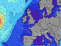 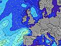 | ||||||||||||||||||||
| Wave Height (m) & direction (?) | ||||||||||||||||||||||||
| Period(s) (?) | 10 | 10 | 10 | 9 | 9 | 9 | 9 | 9 | 9 | 9 | 9 | 7 | 8 | 9 | 12 | 12 | 12 | 12 | 13 | 13 | 13 | 12 | 12 | 11 |
Wave (?)Graph | ||||||||||||||||||||||||
| Energy (?) | 1961 | 1787 | 1679 | 1455 | 1224 | 1137 | 880 | 716 | 651 | 500 | 419 | 661 | 1073 | 2232 | 6000 | 7670 | 7490 | 7341 | 7913 | 6908 | 6390 | 5297 | 4987 | 4735 |
Wind (km/h) | ||||||||||||||||||||||||
| Wind State (?) onshore cross-onshore cross-shore cross-offshore offshore glassy | cross- on | cross- on | cross- on | cross- on | cross- on | cross- on | cross- on | on | cross- on | cross | cross | cross | on | on | on | on | cross- on | cross- on | cross- on | cross- on | cross- on | on | cross- on | cross- on |
High Tide / height (m) | 9:49AM 3.07 | 10:01PM 2.96 | 10:25AM 2.86 | 10:43PM 2.68 | 11:14AM 2.66 | 11:44PM 2.44 | ||||||||||||||||||
Low Tide / height (m) | 3:46PM 0.95 | 4:03AM 1.01 | 4:27PM 1.19 | 4:43AM 1.27 | 5:23PM 1.41 | |||||||||||||||||||
Friday 29 | Saturday 30 | Sunday 31 | Mon 01 | |||||||||||||||||||||
| Sunrise | - | 6:41 | - | - | - | - | - | - | - | 6:43 | - | - | - | - | - | - | - | 6:45 | - | - | - | - | - | - |
| Sunset | - | - | - | - | - | 8:38 | - | - | - | - | - | - | - | 8:37 | - | - | - | - | - | - | - | 8:34 | - | - |
Rain (mm) | - | - | 1 | 1 | 1 | - | 1 | - | - | 2 | 7 | 7 | 2 | - | 1 | 2 | 2 | 2 | 7 | 2 | 2 | 3 | 2 | 1 |
| Temp. °C | 15 | 15 | 15 | 15 | 15 | 15 | 15 | 15 | 15 | 14 | 14 | 16 | 15 | 14 | 14 | 14 | 14 | 14 | 14 | 15 | 15 | 15 | 15 | 15 |
| Feels °C (?) | 8 | 8 | 8 | 9 | 10 | 11 | 11 | 12 | 11 | 9 | 6 | 11 | 7 | 5 | 5 | 5 | 4 | 4 | 4 | 7 | 8 | 7 | 8 | 8 |
- Map Icons:
 Break
Break Live Wave Height (m)
 Live Wind Speed (km/h)
 Surf Rating (10 Max)
 Ocean Swells (m)
- Wind Speed (km/h)
 Recent Eyeball Surf Reports for Mayo and Achill Island

Expand
<
>
View all
29 km away, 2 h 9 min ago
25 km/h
W
0.0
16.9
Air / Water (°C)
Please reload the page to see if there are any updates.
FREE! Surf-Forecast.com widget for your website
The surf report / weather widget below is available to embed on third party websites free of charge and provides a summary of our Keel surf forecast. Simply grab the html code snippet that we provide and paste it into your own site. You can choose your preferred language and metric/imperial units for the surf forecast feed to suit users of your site. Click here to get the code.
 Nearest