

- Forecast
- Maps
- Live
- Weather State
- Spot Information
Balimbing Surf Forecast
/ Sumatra – Mainland (12 surf breaks) /

Balimbing surf Forecast / Sumatra – Mainland / Indonesia
- Map Icons:
 Break
Break Live Wave Height (m)
 Live Wind Speed (km/h)
 Surf Rating (10 Max)
 Ocean Swells (m)
- Wind Speed (km/h)
How big are the waves at Balimbing today?
The current surf forecast for Balimbing at 7PM is: 2.1m 17s primary swell from a South-southwest direction and 0.4m 11s secondary swell from a West-northwest direction, 1.0m 11s secondary swell from a South direction (forecast issued at 06:00pm June 02). The wind direction is predicted to be cross-shore and the swell rating is 4.
| Time (WIB) & Date | Wave Height | Wave Period |
|---|---|---|
| Morning (02 Jun) | - | - |
| Afternoon (02 Jun) | 6ft (1.9m) | 16s |
| Evening (02 Jun) | 7ft (2.1m) | 17s |
Table - waves today at Balimbing. (Swell directed towards the surf break)
Sunday 02 | Monday 03 | Tuesday 04 | Wednesday 05 | Thursday 06 | Friday 07 | Saturday 08 | Sunday 09 | Mon 10 | ||||||||||||||||||||||||||||||||||||||||||||||||||||
| 4 PM | 7 PM | 10 PM | 1 AM | 4 AM | 7 AM | 10 AM | 1 PM | 4 PM | 7 PM | 10 PM | 1 AM | 4 AM | 7 AM | 10 AM | 1 PM | 4 PM | 7 PM | 10 PM | 1 AM | 4 AM | 7 AM | 10 AM | 1 PM | 4 PM | 7 PM | 10 PM | 1 AM | 4 AM | 7 AM | 10 AM | 1 PM | 4 PM | 7 PM | 10 PM | 1 AM | 4 AM | 7 AM | 10 AM | 1 PM | 4 PM | 7 PM | 10 PM | 1 AM | 4 AM | 7 AM | 10 AM | 1 PM | 4 PM | 7 PM | 10 PM | 1 AM | 4 AM | 7 AM | 10 AM | 1 PM | 4 PM | 7 PM | 10 PM | 1 AM | |
Rating (10 max) | ||||||||||||||||||||||||||||||||||||||||||||||||||||||||||||
Swell Height Map |    |    |    |    |    | 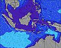 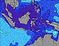 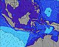 | 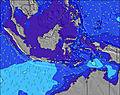   |   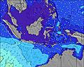 | 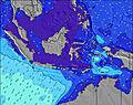 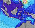 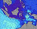 | |||||||||||||||||||||||||||||||||||||||||||||||||||
| Wave Height (m) & direction (?) | ||||||||||||||||||||||||||||||||||||||||||||||||||||||||||||
| Period(s) (?) | 17 | 17 | 17 | 16 | 16 | 16 | 16 | 16 | 17 | 17 | 16 | 16 | 16 | 16 | 16 | 16 | 16 | 16 | 16 | 16 | 16 | 16 | 15 | 15 | 15 | 14 | 14 | 14 | 14 | 14 | 13 | 13 | 19 | 18 | 18 | 18 | 18 | 17 | 17 | 17 | 17 | 16 | 16 | 16 | 16 | 16 | 16 | 16 | 15 | 15 | 15 | 15 | 15 | 14 | 14 | 14 | 14 | 14 | 14 | 13 |
Wave (?)Graph | ||||||||||||||||||||||||||||||||||||||||||||||||||||||||||||
| Energy (?) | 2215 | 2488 | 2987 | 3000 | 2537 | 3304 | 2627 | 2413 | 3945 | 3945 | 3402 | 3592 | 3548 | 3504 | 3417 | 2791 | 2887 | 2582 | 3587 | 3479 | 3024 | 2866 | 2688 | 2320 | 2048 | 1600 | 1435 | 1283 | 1189 | 994 | 863 | 850 | 913 | 1400 | 1385 | 2988 | 2921 | 3138 | 3022 | 3057 | 2952 | 2714 | 2648 | 2419 | 2389 | 2178 | 2151 | 1832 | 1809 | 1786 | 1716 | 1508 | 1488 | 1468 | 1468 | 1447 | 1351 | 1314 | 1110 | 1077 |
Wind (km/h) | ||||||||||||||||||||||||||||||||||||||||||||||||||||||||||||
| Wind State (?) onshore cross-onshore cross-shore cross-offshore offshore glassy | cross | cross | cross | cross | cross- off | cross- off | cross- off | cross | cross | cross- off | cross- off | cross- off | cross- off | cross- off | cross- off | cross- off | cross- off | cross- off | cross- off | cross- off | cross- off | off | glass | cross- on | cross- on | cross- on | glass | glass | cross | cross | cross | cross | cross | cross | cross | cross- off | cross- off | cross- off | cross- off | cross | cross | cross | cross | cross- off | cross- off | cross- off | cross- off | cross | cross | cross | cross- off | cross- off | cross- off | cross- off | cross | cross | cross | cross | cross | cross |
High Tide / height (m) | 2:58PM 0.81 | 3:51AM 1.12 | 4:16PM 0.77 | 4:42AM 1.22 | 5:24PM 0.74 | 5:31AM 1.29 | 6:21PM 0.73 | 6:17AM 1.34 | 7:12PM 0.73 | 7:02AM 1.35 | 7:58PM 0.73 | 7:47AM 1.33 | 8:42PM 0.73 | 8:30AM 1.29 | 9:25PM 0.73 | |||||||||||||||||||||||||||||||||||||||||||||
Low Tide / height (m) | 9:02PM 0.29 | 10:43AM 0.30 | 9:54PM 0.29 | 11:45AM 0.19 | 10:45PM 0.28 | 12:37PM 0.09 | 11:33PM 0.27 | 1:24PM 0.03 | 12:19AM 0.26 | 2:09PM 0.01 | 1:04AM 0.25 | 2:51PM 0.01 | 1:47AM 0.26 | 3:31PM 0.05 | ||||||||||||||||||||||||||||||||||||||||||||||
Sunday 02 | Monday 03 | Tuesday 04 | Wednesday 05 | Thursday 06 | Friday 07 | Saturday 08 | Sunday 09 | Mon 10 | ||||||||||||||||||||||||||||||||||||||||||||||||||||
| Sunrise | - | - | - | - | - | 6:05 | - | - | - | - | - | - | - | 6:05 | - | - | - | - | - | - | - | 6:05 | - | - | - | - | - | - | - | 6:05 | - | - | - | - | - | - | - | 6:05 | - | - | - | - | - | - | - | 6:07 | - | - | - | - | - | - | - | 6:07 | - | - | - | - | - | - |
| Sunset | 5:52 | - | - | - | - | - | - | - | 5:52 | - | - | - | - | - | - | - | 5:53 | - | - | - | - | - | - | - | 5:53 | - | - | - | - | - | - | - | 5:53 | - | - | - | - | - | - | - | 5:53 | - | - | - | - | - | - | - | 5:53 | - | - | - | - | - | - | - | 5:53 | - | - | - |
Rain (mm) | 1 | - | - | 1 | 2 | 2 | 1 | - | - | - | - | 1 | 1 | - | - | - | - | 2 | 2 | 4 | 4 | 2 | 1 | 1 | 1 | 3 | 2 | 2 | 1 | - | - | - | - | - | - | - | - | - | - | - | - | - | - | - | - | - | - | - | - | - | - | - | - | - | - | - | - | 1 | 1 | 1 |
| Temp. °C | 29 | 28 | 28 | 28 | 27 | 27 | 28 | 29 | 29 | 28 | 28 | 27 | 27 | 27 | 28 | 29 | 29 | 28 | 28 | 27 | 27 | 26 | 27 | 28 | 28 | 27 | 27 | 27 | 27 | 27 | 28 | 29 | 28 | 28 | 28 | 27 | 27 | 27 | 28 | 28 | 28 | 28 | 28 | 27 | 27 | 27 | 28 | 28 | 28 | 28 | 28 | 27 | 27 | 27 | 28 | 28 | 28 | 28 | 27 | 27 |
| Feels °C (?) | 32 | 31 | 31 | 31 | 30 | 31 | 32 | 31 | 30 | 30 | 30 | 29 | 29 | 30 | 30 | 31 | 31 | 30 | 30 | 29 | 30 | 29 | 31 | 31 | 31 | 31 | 32 | 32 | 31 | 30 | 29 | 30 | 29 | 29 | 30 | 29 | 30 | 30 | 32 | 31 | 30 | 31 | 31 | 30 | 31 | 31 | 32 | 30 | 30 | 31 | 31 | 29 | 30 | 30 | 31 | 30 | 30 | 30 | 28 | 29 |
FREE! Surf-Forecast.com widget for your website
The surf report / weather widget below is available to embed on third party websites free of charge and provides a summary of our Balimbing surf forecast. Simply grab the html code snippet that we provide and paste it into your own site. You can choose your preferred language and metric/imperial units for the surf forecast feed to suit users of your site. Click here to get the code.


 Nearest