

Surf Forecasts:

How big are the waves at Wonthaggi today (09 Jun):
- Morning surf: Morning surf (09 Jun, local time) - 4.5ft (1.4m), 14s period with WSW swell.
- Afternoon surf: Afternoon surf (09 Jun, local time) - 4ft (1.2m), 14s period with SW swell.
- Evening surf: Evening surf (09 Jun, local time) - 3.5ft (1.0m), 16s period with SW swell.
The current surf forecast for Wonthaggi at 5PM is: 1.2m 14s primary swell from a West-southwest direction and 0.5m 18s secondary swell from a Southwest direction, 0.4m 4s secondary swell from a North-northwest direction (forecast issued at 09:00am June 09). The wind direction is predicted to be cross-offshore.
| Time (AEST) & Date | Wave Height | Wave Period |
|---|---|---|
| Morning (09 Jun) | 4.5ft (1.4m) | 14s |
| Afternoon (09 Jun) | 4ft (1.2m) | 14s |
| Evening (09 Jun) | 3.5ft (1.0m) | 16s |
Table - waves today at Wonthaggi. (Swell directed towards the surf break)
Updates in hr min s Forecast update imminent
Short Range ForecastLight rain (total 2mm), mostly falling on Wed afternoon. Very mild (max 18°C on Tue morning, min 12°C on Tue morning). Winds decreasing (fresh winds from the NNW on Wed morning, calm by Thu morning). | ||||||||||||||||||||||||
Tuesday 9 | Wednesday 10 | Thursday 11 | Fri 12 | |||||||||||||||||||||
7 AM | 10 AM | 1 PM | 4 PM | 7 PM | 10 PM | 1 AM | 4 AM | 7 AM | 10 AM | 1 PM | 4 PM | 7 PM | 10 PM | 1 AM | 4 AM | 7 AM | 10 AM | 1 PM | 4 PM | 7 PM | 10 PM | 1 AM | 4 AM | |
Swell Height Map |  |  |  | 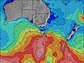 |  |  | 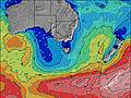 |  |  | |||||||||||||||
Wave Height (m) Direction Period (s) | WSW 14 | WSW 14 | WSW 14 | WSW 14 | WSW 14 | SW 16 | WSW 16 | WSW 16 | WSW 15 | WSW 14 | WSW 14 | WSW 14 | WSW 14 | WSW 14 | WSW 18 | WSW 17 | WSW 16 | WSW 16 | WSW 16 | WSW 15 | WSW 15 | WSW 15 | WSW 14 | WSW 14 |
Wave Graph | ||||||||||||||||||||||||
934 | 763 | 644 | 486 | 486 | 527 | 957 | 801 | 665 | 630 | 612 | 1038 | 1214 | 866 | 1021 | 2667 | 3152 | 3460 | 3116 | 2400 | 2042 | 1860 | 1538 | 1368 | |
Wind (km/h) | ||||||||||||||||||||||||
Wind State on-shore cross-onshore cross-shore cross-offshore off-shore glassy | cross-off | cross-off | cross-off | cross-off | cross-off | cross-off | cross-off | cross-off | cross-off | cross | cross | cross | cross-on | cross-on | on | cross | cross-off | cross-off | glassy | glassy | off | cross-off | cross-off | cross-off |
High Tide | 5:13AM1.85m | 5:39PM2.14m | 6:05AM1.88m | 6:16PM2.10m | 7:03AM1.92m | 6:58PM2.05m | ||||||||||||||||||
Low Tide | 11:14AM0.60m | 00:02AM0.62m | 12:00PM0.71m | 00:45AM0.53m | 12:55PM0.82m | 1:34AM0.41m | ||||||||||||||||||
7:30 | — | — | — | — | — | — | — | 7:31 | — | — | — | — | — | — | — | 7:31 | — | — | — | — | — | — | 7:31 | |
— | — | — | 5:02 | — | — | — | — | — | — | — | 5:02 | — | — | — | — | — | — | — | 5:01 | — | — | — | 5:01 | |
mm | — | — | — | — | — | — | — | — | — | — | — | — | 1 | 1 | — | — | — | — | — | — | — | — | — | — |
Temp °C | 13 | 12 | 18 | 18 | 16 | 16 | 16 | 16 | 16 | 16 | 15 | 15 | 15 | 14 | 13 | 13 | 13 | 13 | 15 | 16 | 16 | 16 | 16 | 16 |
Feels °C | 9 | 8 | 14 | 15 | 13 | 12 | 10 | 9 | 10 | 10 | 10 | 12 | 13 | 13 | 12 | 12 | 12 | 12 | 14 | 15 | 14 | 14 | 14 | 13 |
Swell 1 Height (m) Direction Period (s) | WSW 14 | WSW 14 | WSW 14 | WSW 14 | WSW 14 | SW 16 | WSW 16 | WSW 16 | WSW 15 | WSW 14 | WSW 14 | WSW 14 | WSW 14 | WSW 14 | WSW 13 | WSW 17 | WSW 16 | WSW 16 | WSW 16 | WSW 15 | WSW 15 | WSW 15 | WSW 14 | WSW 14 |
934 | 763 | 644 | 486 | 486 | 527 | 957 | 801 | 665 | 630 | 612 | 1038 | 1214 | 866 | 569 | 2667 | 3152 | 3460 | 3116 | 2400 | 2042 | 1860 | 1538 | 1368 | |
Swell 2 Height (m) Direction Period (s) | — | — | SW 19 | SW 18 | SW 18 | WSW 13 | — | E 5 | E 5 | E 5 | E 7 | E 7 | SW 19 | WSW 18 | WSW 18 | — | — | — | — | — | — | — | — | — |
— | — | 58 | 84 | 249 | 290 | — | 4 | 2 | 2 | 4 | 4 | 181 | 547 | 1021 | — | — | — | — | — | — | — | — | — | |
Swell 3 Height (m) Direction Period (s) | — | — | — | — | NW 5 | NW 4 | — | — | — | — | — | — | E 7 | SW 18 | — | — | — | — | — | — | — | — | — | — |
— | — | — | — | 7 | 5 | — | — | — | — | — | — | 4 | 375 | — | — | — | — | — | — | — | — | — | — | |
Wind waves Height (m) Direction Period (s) | N 2 | N 3 | NNW 3 | NW 4 | NNW 4 | N 3 | N 3 | NNW 4 | NNW 5 | NNW 5 | NW 5 | WNW 5 | — | — | — | — | — | — | — | — | — | — | NNE 3 | NNW 3 |
2 | 4 | 5 | 9 | 6 | 4 | 5 | 44 | 56 | 77 | 74 | 39 | — | — | — | — | — | — | — | — | — | — | 5 | 3 | |
Nearest Offshore or Glassy | ||||||||||||||||||||||||
Distance (km) | 7 | 7 | 11 | 7 | 7 | 7 | 16 | 60 | 432 | 432 | 11 | 11 | 7 | 11 | 11 | 7 | 7 | 7 | 7 | 7 | 7 | 7 | 7 | 7 |
Best forecast wave conditions in East Coast of Victoria | ||||||||||||||||||||||||
Best forecast wave conditions in Australia | ||||||||||||||||||||||||
Header Global | ||||||||||||||||||||||||
- Map Icons:
 Break
Break Live Wave Height (m)
 Live Wind Speed (km/h)
 Surf Rating (10 Max)
 Ocean Swells (m)
- Wind Speed (km/h)


FREE! Surf-Forecast.com widget for your website
The surf report / weather widget below is available to embed on third party websites free of charge and provides a summary of our Wonthaggi surf forecast. Simply grab the html code snippet that we provide and paste it into your own site. You can choose your preferred language and metric/imperial units for the surf forecast feed to suit users of your site. Click here to get the code.
 Nearest