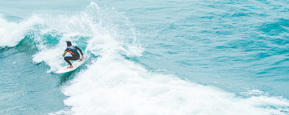

Surf Forecasts:

How big are the waves at Ticla today (09 Jun):
- Morning surf: Morning surf (09 Jun, local time) - 7ft (2.2m), 17s period with SSW swell.
- Afternoon surf: Afternoon surf (09 Jun, local time) - 7ft (2.1m), 17s period with SSW swell.
- Evening surf: Evening surf (09 Jun, local time) - 6ft (1.9m), 16s period with SSW swell.
The current surf forecast for Ticla at 5AM is: 2.2m 17s primary swell from a South-southwest direction (forecast issued at 11:00pm June 08). An open ocean swell of 0.2m 10s is not directed at the surf break, a second open ocean swell of 1.2m 6s is not directed at the surf break. The wind direction is predicted to be cross-shore.
| Time (CST) & Date | Wave Height | Wave Period |
|---|---|---|
| Morning (09 Jun) | 7ft (2.2m) | 17s |
| Afternoon (09 Jun) | 7ft (2.1m) | 17s |
| Evening (09 Jun) | 6ft (1.9m) | 16s |
Table - waves today at Ticla. (Swell directed towards the surf break)
Updates in hr min s Forecast update imminent
Short Range ForecastHeavy rain (total 84mm), heaviest during Tue afternoon. Warm (max 28°C on Wed morning, min 25°C on Tue afternoon). Wind will be generally light. | ||||||||||||||||||||||||
Tuesday 9 | Wednesday 10 | Thursday 11 | ||||||||||||||||||||||
9 PM | 12 AM | 3 AM | 6 AM | 9 AM | 12 PM | 3 PM | 6 PM | 9 PM | 12 AM | 3 AM | 6 AM | 9 AM | 12 PM | 3 PM | 6 PM | 9 PM | 12 AM | 3 AM | 6 AM | 9 AM | 12 PM | 3 PM | 6 PM | |
Swell Height Map |  |  |  |  |  |  |  |  |  | 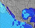 | ||||||||||||||
Wave Height (m) Direction Period (s) | SSW 18 | SSW 18 | SSW 17 | SSW 17 | SSW 17 | SSW 17 | SSW 17 | SSW 16 | SSW 16 | SSW 16 | SSW 16 | SSW 16 | SSW 16 | SSW 16 | SSW 16 | SSW 15 | SSW 14 | SSW 14 | SSW 14 | SSW 14 | SSW 14 | SSW 14 | SSW 14 | SSW 14 |
Wave Graph | ||||||||||||||||||||||||
3349 | 2976 | 2909 | 2876 | 2876 | 2842 | 2574 | 2084 | 1762 | 1762 | 1591 | 1762 | 1591 | 1571 | 1376 | 1059 | 911 | 1010 | 943 | 943 | 943 | 789 | 687 | 678 | |
Wind (km/h) | ||||||||||||||||||||||||
Wind State on-shore cross-onshore cross-shore cross-offshore off-shore glassy | cross | cross | cross | cross | cross | glassy | glassy | cross-on | cross | glassy | cross-off | cross-off | glassy | cross-on | cross-on | cross-on | cross | cross | cross | cross | cross-on | cross-on | cross-on | cross-on |
High Tide | 6:39AM0.49m | 5:47PM0.62m | 7:37AM0.56m | 6:05PM0.65m | 8:28AM0.62m | |||||||||||||||||||
Low Tide | 1:02AM0.35m | 11:44AM0.42m | 1:03AM0.25m | 12:36PM0.45m | 1:26AM0.15m | 1:19PM0.48m | ||||||||||||||||||
— | — | — | 6:16 | — | — | — | — | — | — | — | 6:16 | — | — | — | — | — | — | — | 6:16 | — | — | — | — | |
— | — | — | — | — | — | — | 7:28 | — | — | — | — | — | — | — | 7:29 | — | — | — | — | — | — | — | 7:29 | |
mm | 3 | 2 | 3 | 3 | 3 | 7 | 17 | 28 | 3 | 3 | 7 | 4 | 1 | — | — | — | — | — | — | — | — | — | — | — |
Temp °C | 27 | 27 | 26 | 26 | 27 | 26 | 25 | 25 | 26 | 25 | 25 | 26 | 27 | 28 | 28 | 28 | 27 | 27 | 27 | 27 | 28 | 28 | 28 | 27 |
Feels °C | 28 | 28 | 27 | 28 | 30 | 31 | 30 | 29 | 30 | 30 | 29 | 30 | 31 | 31 | 29 | 29 | 29 | 29 | 30 | 30 | 31 | 30 | 30 | 28 |
Swell 1 Height (m) Direction Period (s) | SSW 18 | SSW 18 | SSW 17 | SSW 17 | SSW 17 | SSW 17 | SSW 17 | SSW 16 | SSW 16 | SSW 16 | SSW 16 | SSW 16 | SSW 16 | SSW 16 | SSW 16 | SSW 15 | SSW 14 | SSW 14 | SSW 14 | SSW 14 | SSW 14 | SSW 14 | SSW 14 | SSW 14 |
3349 | 2976 | 2909 | 2876 | 2876 | 2842 | 2574 | 2084 | 1762 | 1762 | 1591 | 1762 | 1591 | 1571 | 1376 | 1059 | 911 | 1010 | 943 | 943 | 943 | 789 | 687 | 678 | |
Swell 2 Height (m) Direction Period (s) | — | WNW 10 | WNW 10 | WNW 10 | W 6 | W 6 | W 6 | W 6 | W 5 | W 5 | NW 11 | W 5 | W 5 | W 5 | NW 10 | NW 10 | NW 10 | WNW 10 | SSW 20 | SSW 20 | SSW 20 | SSW 20 | SSE 7 | SSW 19 |
— | 10 | 10 | 10 | 73 | 54 | 41 | 38 | 33 | 33 | 4 | 40 | 24 | 18 | 4 | 4 | 4 | 9 | 38 | 75 | 75 | 76 | 18 | 146 | |
Swell 3 Height (m) Direction Period (s) | — | — | — | SW 22 | WNW 10 | WNW 11 | WNW 11 | NW 11 | SSW 8 | SSW 8 | SW 20 | NW 11 | SSW 7 | NW 11 | W 18 | S 22 | S 22 | — | WNW 10 | WNW 10 | WNW 10 | WNW 10 | SSW 20 | SSE 7 |
— | — | — | 19 | 11 | 12 | 12 | 5 | 32 | 32 | 16 | 5 | 30 | 4 | 6 | 9 | 9 | — | 10 | 10 | 10 | 10 | 75 | 17 | |
Wind waves Height (m) Direction Period (s) | WNW 6 | WNW 6 | WNW 6 | WNW 6 | WNW 6 | — | WNW 6 | WNW 6 | — | — | WSW 5 | — | — | — | W 5 | W 5 | W 5 | WNW 6 | WNW 5 | WNW 5 | WSW 6 | W 6 | WSW 6 | W 3 |
155 | 155 | 130 | 112 | 142 | — | 69 | 52 | — | — | 62 | — | — | — | 12 | 12 | 12 | 3 | 14 | 9 | 13 | 12 | 12 | 4 | |
Nearest Offshore or Glassy | ||||||||||||||||||||||||
Distance (km) | 164 | 100 | 73 | 44 | 4 | 0 | 0 | 193 | 16 | 0 | 0 | 0 | 0 | 89 | 327 | 181 | 4 | 4 | 4 | 73 | 100 | 318 | 318 | 318 |
Best forecast wave conditions in Michoacan | ||||||||||||||||||||||||
Best forecast wave conditions in Mexico | ||||||||||||||||||||||||
Header Global | ||||||||||||||||||||||||
- Map Icons:
 Break
Break Live Wave Height (m)
 Live Wind Speed (km/h)
 Surf Rating (10 Max)
 Ocean Swells (m)
- Wind Speed (km/h)


FREE! Surf-Forecast.com widget for your website
The surf report / weather widget below is available to embed on third party websites free of charge and provides a summary of our Ticla surf forecast. Simply grab the html code snippet that we provide and paste it into your own site. You can choose your preferred language and metric/imperial units for the surf forecast feed to suit users of your site. Click here to get the code.
 Nearest