

Sachuest Beach (2nd Beach) Surf Guide
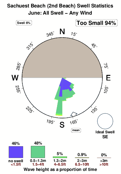
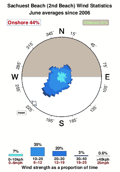
Sachuest Beach(2nd Beach) in Rhode Island is a fairly exposed beach and point break that has fairly consistent surf and can work at any time of the year. The best wind direction is from the north. Windswells and groundswells in equal measure and the best swell direction is from the southeast. Waves at the beach break both left and right and there is a left hand point break as well. The quality of the surf isn't affected by the tide. Even when there are waves, it's not likley to be crowded. Dangerous rips are a hazard of surfing here.
Sachuest Beach (2nd Beach) Spot Info
| Type: | Rating: | Reliability: | Todays Sea Temp*: |
|---|---|---|---|
| fairly consistent | 16.5°C*ocean temperature recorded from satellite |
Surfing Sachuest Beach (2nd Beach):
The best conditions reported for surf at Sachuest Beach (2nd Beach) occur when a Southeast swell combines with an offshore wind direction from the North.
What's the best time of year to surf Sachuest Beach (2nd Beach) (for consistent clean waves)?
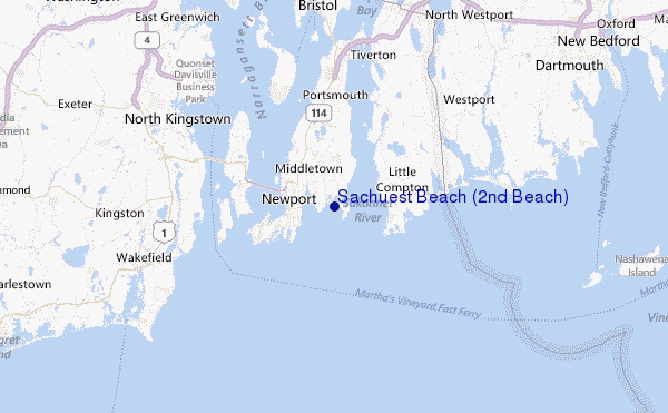
Explore Sachuest Beach (2nd Beach) Location Map
Interactive Sachuest Beach (2nd Beach) surf break location map. View information about nearby surf breaks, their wave consistency and rating compared to other spots in the region. Current swell conditions from local buoys are shown along with live wind speed and direction from nearby weather stations. Click icons on the map for more detail. The closest passenger airport to Sachuest Beach (2nd Beach) is Theodore Francis Green State (Providence) Airport (PVD) in USA, 30 km (19 miles) away (directly). The second nearest airport to Sachuest Beach (2nd Beach) is North Central State (Smithfield) Airport (SFZ), also in USA, 52 km (32 miles) away.
- Map Icons:
 Break
Break Live Wave Height (m)
 Live Wind Speed (km/h)
 Surf Rating (10 Max)
 Ocean Swells (m)
- Wind Speed (km/h)
Tuesday, 9 June 2026, 08:30 Local Time
| Tuesday 09 | ||||
| 5AM | 8AM | 11AM | 2PM | |
| Wave (m) | ||||
| Period (s) | 7 | 4 | 4 | 4 |
| Wind (km/h) | ||||
| Wind State | cross | cross | cross- on |
cross- on |
Tides at Sachuest Beach (2nd Beach)
| NEXT | IS AT (local time) | remaining |
|---|---|---|
| high tide | ||
| low tide |
Sachuest Beach (2nd Beach) Sea Temperature
Sunny with pleasantly warm air temperatures (feels like 21.0 °C) at Sachuest Beach (2nd Beach), yet the sea remains several degrees colder than the air. Most surfers will need a spring wetsuit though a summer suit or even a shorty may suffice for a short session.
Swell History at Sachuest Beach (2nd Beach)
Surf stats for Sachuest Beach (2nd Beach), see the swell variation by month or season on the history page here.

Wind History at Sachuest Beach (2nd Beach)
Wind stats for Sachuest Beach (2nd Beach), see the variation in direction and stength by month or season on the history page here.
Other Nearby Breaks Closest To:
Discover surf breaks near Sachuest Beach (2nd Beach). Click below to view there surf guides.
 Nearest