

Surf Forecasts:

How big are the waves at Rodiles - Main Beach today (09 Jun):
- Morning surf: Morning surf (09 Jun, local time) - 4ft (1.2m), 10s period with NW swell.
- Afternoon surf: Afternoon surf (09 Jun, local time) - 4ft (1.2m), 11s period with NW swell.
- Evening surf: Evening surf (09 Jun, local time) - 4.5ft (1.4m), 11s period with NNW swell.
The current surf forecast for Rodiles - Main Beach at 1PM is: 1.2m 10s primary swell from a Northwest direction and 0.6m 6s secondary swell from a North direction (forecast issued at 07:00am June 09). The wind direction is predicted to be glassy and the swell rating is 2.
| Time (CEST) & Date | Wave Height | Wave Period |
|---|---|---|
| Morning (09 Jun) | 4ft (1.2m) | 10s |
| Afternoon (09 Jun) | 4ft (1.2m) | 11s |
| Evening (09 Jun) | 4.5ft (1.4m) | 11s |
Table - waves today at Rodiles - Main Beach. (Swell directed towards the surf break)
Updates in hr min s Forecast update imminent
Short Range ForecastMostly dry. Very mild (max 18°C on Thu afternoon, min 12°C on Tue night). Wind will be generally light. | ||||||||||||||||||||||||
Tuesday 9 | Wednesday 10 | Thursday 11 | Fri 12 | |||||||||||||||||||||
5 AM | 8 AM | 11 AM | 2 PM | 5 PM | 8 PM | 11 PM | 2 AM | 5 AM | 8 AM | 11 AM | 2 PM | 5 PM | 8 PM | 11 PM | 2 AM | 5 AM | 8 AM | 11 AM | 2 PM | 5 PM | 8 PM | 11 PM | 2 AM | |
Swell Height Map |  |  |  |  | 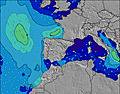 |  |  | 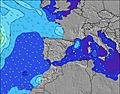 |  |  | ||||||||||||||
Wave Height (m) Direction Period (s) | NW 10 | NW 10 | NW 10 | NW 11 | NW 11 | NNW 11 | NNW 11 | NNW 11 | NNW 11 | NNW 11 | NNW 11 | NW 11 | NNW 10 | NNW 10 | NNW 10 | NNW 10 | NW 10 | NW 10 | NNW 9 | NW 9 | NW 9 | NW 9 | NW 9 | NW 8 |
Wave Graph | ||||||||||||||||||||||||
350 | 308 | 271 | 319 | 326 | 425 | 523 | 594 | 595 | 513 | 523 | 458 | 409 | 340 | 308 | 256 | 184 | 150 | 148 | 120 | 115 | 97 | 79 | 74 | |
Wind (km/h) | ||||||||||||||||||||||||
Wind State on-shore cross-onshore cross-shore cross-offshore off-shore glassy | glassy | glassy | glassy | on | cross-on | cross-on | glassy | glassy | off | off | cross | cross-on | cross-on | cross-on | glassy | cross-off | cross-off | cross-off | cross-on | on | cross-on | cross-on | cross-on | cross |
High Tide | 11:55AM2.79m | 00:15AM3.01m | 12:58PM2.92m | 1:19AM3.12m | 1:59PM3.11m | |||||||||||||||||||
Low Tide | 5:39AM0.91m | 5:59PM1.05m | 6:40AM0.81m | 7:03PM0.93m | 7:39AM0.68m | 8:05PM0.73m | ||||||||||||||||||
6:39 | — | — | — | — | — | — | — | 6:39 | — | — | — | — | — | — | — | 6:39 | — | — | — | — | — | — | 6:39 | |
— | — | — | — | — | 10:00 | — | — | — | — | — | — | — | 10:00 | — | — | — | — | — | — | — | 10:01 | — | 10:01 | |
mm | — | — | — | — | — | — | — | — | — | — | — | — | — | — | — | — | — | — | — | — | — | — | — | — |
Temp °C | 14 | 14 | 14 | 16 | 15 | 15 | 15 | 14 | 12 | 12 | 16 | 16 | 16 | 16 | 14 | 12 | 12 | 12 | 16 | 18 | 18 | 17 | 14 | 14 |
Feels °C | 13 | 14 | 13 | 14 | 13 | 13 | 14 | 13 | 10 | 10 | 15 | 14 | 14 | 14 | 14 | 11 | 11 | 11 | 14 | 15 | 15 | 15 | 12 | 12 |
Swell 1 Height (m) Direction Period (s) | NW 10 | NW 10 | NW 10 | NW 11 | NW 11 | NNW 11 | NNW 11 | NNW 11 | NNW 11 | NNW 11 | NNW 11 | NW 11 | NNW 10 | NNW 10 | NNW 10 | NNW 10 | NW 10 | NW 10 | NNW 9 | NW 9 | NW 9 | NW 9 | NW 9 | NW 8 |
350 | 308 | 271 | 319 | 326 | 425 | 523 | 594 | 595 | 513 | 523 | 458 | 409 | 340 | 308 | 256 | 184 | 150 | 148 | 120 | 115 | 97 | 79 | 74 | |
Swell 2 Height (m) Direction Period (s) | N 6 | N 6 | N 6 | N 6 | N 6 | — | N 10 | N 10 | N 12 | N 11 | N 10 | N 10 | N 10 | N 10 | N 10 | N 10 | N 10 | N 9 | N 6 | NNW 8 | NNW 6 | NNW 9 | N 8 | N 5 |
22 | 22 | 22 | 22 | 15 | — | 8 | 8 | 11 | 9 | 35 | 19 | 19 | 19 | 8 | 8 | 67 | 63 | 9 | 24 | 6 | 26 | 12 | 5 | |
Swell 3 Height (m) Direction Period (s) | N 10 | N 10 | N 10 | — | — | — | — | — | — | — | — | — | — | — | — | — | — | — | N 9 | NNW 6 | N 9 | N 5 | NNW 5 | N 8 |
8 | 2 | 7 | — | — | — | — | — | — | — | — | — | — | — | — | — | — | — | 6 | 6 | 6 | 5 | 6 | 6 | |
Wind waves Height (m) Direction Period (s) | — | — | — | — | — | — | — | — | — | — | — | — | — | — | — | — | — | — | — | — | ENE 3 | E 4 | E 4 | E 4 |
— | — | — | — | — | — | — | — | — | — | — | — | — | — | — | — | — | — | — | — | 3 | 9 | 14 | 19 | |
Nearest Offshore or Glassy | ||||||||||||||||||||||||
Distance (km) | 0 | 0 | 0 | 20 | 68 | 15 | 0 | 0 | 0 | 0 | 14 | 157 | 52 | 51 | 0 | 0 | 0 | 0 | 20 | 20 | 23 | 15 | 7 | 7 |
Best forecast wave conditions in Asturias | ||||||||||||||||||||||||
Best forecast wave conditions in Spain (Europe) | ||||||||||||||||||||||||
Header Global | ||||||||||||||||||||||||
- Map Icons:
 Break
Break Live Wave Height (m)
 Live Wind Speed (km/h)
 Surf Rating (10 Max)
 Ocean Swells (m)
- Wind Speed (km/h)


FREE! Surf-Forecast.com widget for your website
The surf report / weather widget below is available to embed on third party websites free of charge and provides a summary of our Rodiles - Main Beach surf forecast. Simply grab the html code snippet that we provide and paste it into your own site. You can choose your preferred language and metric/imperial units for the surf forecast feed to suit users of your site. Click here to get the code.
 Nearest