

Surf Forecasts:

How big are the waves at Renaca today (09 Jun):
- Morning surf: Morning surf (09 Jun, local time) - 4.5ft (1.4m), 12s period with SW swell.
- Afternoon surf: Afternoon surf (09 Jun, local time) - 4ft (1.2m), 12s period with SW swell.
- Evening surf: Evening surf (09 Jun, local time) - 4ft (1.2m), 13s period with SW swell.
The current surf forecast for Renaca at 6AM is: 1.4m 12s primary swell from a Southwest direction and 0.4m 18s secondary swell from a Southwest direction (forecast issued at 01:00am June 09). The wind direction is predicted to be glassy and the swell rating is 3.
| Time (-04) & Date | Wave Height | Wave Period |
|---|---|---|
| Morning (09 Jun) | 4.5ft (1.4m) | 12s |
| Afternoon (09 Jun) | 4ft (1.2m) | 12s |
| Evening (09 Jun) | 4ft (1.2m) | 13s |
Table - waves today at Renaca. (Swell directed towards the surf break)
Updates in hr min s Forecast update imminent
Short Range ForecastLight rain (total 8mm), mostly falling on Wed morning. Very mild (max 17°C on Thu morning, min 12°C on Wed morning). Wind will be generally light. | ||||||||||||||||||||||||
Tuesday 9 | Wednesday 10 | Thursday 11 | ||||||||||||||||||||||
2 AM | 5 AM | 8 AM | 11 AM | 2 PM | 5 PM | 8 PM | 11 PM | 2 AM | 5 AM | 8 AM | 11 AM | 2 PM | 5 PM | 8 PM | 11 PM | 2 AM | 5 AM | 8 AM | 11 AM | 2 PM | 5 PM | 8 PM | 11 PM | |
Swell Height Map |  | 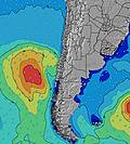 |  |  | 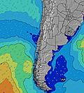 |  |  | 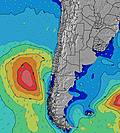 |  | |||||||||||||||
Wave Height (m) Direction Period (s) | SW 13 | SW 12 | SW 12 | SW 12 | SW 12 | SW 12 | SW 13 | SW 17 | SW 14 | SW 14 | SW 16 | SW 16 | SW 16 | SW 15 | SW 15 | SW 15 | SW 15 | SW 15 | SW 15 | SW 15 | SW 15 | SW 14 | SW 14 | SW 14 |
Wave Graph | ||||||||||||||||||||||||
734 | 549 | 540 | 540 | 442 | 449 | 464 | 1336 | 667 | 667 | 1333 | 1317 | 1267 | 1169 | 1486 | 1718 | 1951 | 2197 | 2208 | 2309 | 2416 | 2492 | 2492 | 1902 | |
Wind (km/h) | ||||||||||||||||||||||||
Wind State on-shore cross-onshore cross-shore cross-offshore off-shore glassy | cross-on | glassy | cross-on | glassy | cross | glassy | cross-off | off | glassy | glassy | cross-off | off | off | glassy | cross-on | cross | cross | cross | cross | cross-on | on | on | cross-on | cross-on |
High Tide | 5:11AM0.92m | 4:49PM1.02m | 6:03AM1.04m | 5:54PM0.98m | 6:52AM1.17m | 6:58PM0.96m | ||||||||||||||||||
Low Tide | 10:54AM0.49m | 11:31PM0.25m | 12:10PM0.43m | 00:16AM0.23m | 1:17PM0.33m | |||||||||||||||||||
— | 7:43 | — | — | — | — | — | — | — | 7:45 | — | — | — | — | — | — | — | 7:45 | — | — | — | — | — | — | |
— | — | — | — | — | 5:45 | — | — | — | — | — | — | — | 5:45 | — | — | — | — | — | — | — | 5:45 | — | — | |
mm | — | — | — | — | — | — | — | — | — | — | 4 | 2 | 2 | — | — | — | — | — | — | — | — | — | — | — |
Temp °C | 12 | 12 | 13 | 14 | 15 | 14 | 13 | 13 | 13 | 13 | 12 | 14 | 14 | 15 | 15 | 14 | 13 | 13 | 12 | 17 | 17 | 17 | 15 | 14 |
Feels °C | 11 | 12 | 11 | 14 | 13 | 13 | 12 | 12 | 12 | 13 | 10 | 12 | 11 | 14 | 13 | 11 | 9 | 10 | 9 | 15 | 14 | 14 | 13 | 12 |
Swell 1 Height (m) Direction Period (s) | SW 13 | SW 12 | SW 12 | SW 12 | SW 12 | SW 12 | SW 13 | SW 17 | SW 14 | SW 14 | SW 16 | SW 16 | SW 16 | SW 15 | SW 15 | SW 15 | SW 15 | SW 15 | SW 15 | SW 15 | SW 15 | SW 14 | SW 14 | SW 14 |
734 | 549 | 540 | 540 | 442 | 449 | 464 | 1336 | 667 | 667 | 1333 | 1317 | 1267 | 1169 | 1486 | 1718 | 1951 | 2197 | 2208 | 2309 | 2416 | 2492 | 2492 | 1902 | |
Swell 2 Height (m) Direction Period (s) | NW 13 | SW 18 | SW 18 | NW 13 | SW 16 | SW 16 | SW 16 | NW 13 | SW 18 | SW 18 | NW 12 | WNW 12 | W 7 | W 7 | WSW 11 | WSW 11 | W 11 | W 11 | W 11 | W 11 | W 11 | NW 12 | NW 12 | NW 12 |
45 | 111 | 112 | 45 | 165 | 127 | 264 | 27 | 455 | 449 | 23 | 14 | 63 | 42 | 40 | 40 | 37 | 37 | 37 | 35 | 35 | 6 | 6 | 6 | |
Swell 3 Height (m) Direction Period (s) | SW 18 | NW 13 | NW 13 | NW 11 | NW 13 | SW 19 | WSW 20 | NW 11 | NW 13 | NW 13 | — | NW 10 | WNW 12 | W 11 | NW 12 | NW 12 | NW 12 | NW 12 | NW 12 | WNW 12 | NW 12 | NW 12 | NW 12 | NW 12 |
50 | 45 | 45 | 5 | 45 | 181 | 149 | 5 | 27 | 26 | — | 4 | 14 | 22 | 23 | 23 | 23 | 23 | 23 | 14 | 6 | 6 | 6 | 6 | |
Wind waves Height (m) Direction Period (s) | — | — | — | — | — | — | — | — | — | — | NE 3 | NNE 3 | N 4 | — | — | — | — | — | — | — | — | — | — | SW 5 |
— | — | — | — | — | — | — | — | — | — | 2 | 6 | 7 | — | — | — | — | — | — | — | — | — | — | 47 | |
Nearest Offshore or Glassy | ||||||||||||||||||||||||
Distance (km) | 27 | 0 | 39 | 0 | 131 | 0 | 0 | 0 | 0 | 0 | 0 | 0 | 0 | 0 | 3 | 3 | 3 | 3 | 3 | 3 | 483 | 5 | 3 | 3 |
Best forecast wave conditions in Santiago | ||||||||||||||||||||||||
Best forecast wave conditions in Chile | ||||||||||||||||||||||||
Header Global | ||||||||||||||||||||||||
- Map Icons:
 Break
Break Live Wave Height (m)
 Live Wind Speed (km/h)
 Surf Rating (10 Max)
 Ocean Swells (m)
- Wind Speed (km/h)


FREE! Surf-Forecast.com widget for your website
The surf report / weather widget below is available to embed on third party websites free of charge and provides a summary of our Renaca surf forecast. Simply grab the html code snippet that we provide and paste it into your own site. You can choose your preferred language and metric/imperial units for the surf forecast feed to suit users of your site. Click here to get the code.
 Nearest