

Pleasure Point-Second Peak Surf Guide
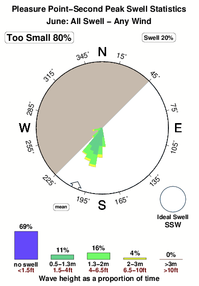
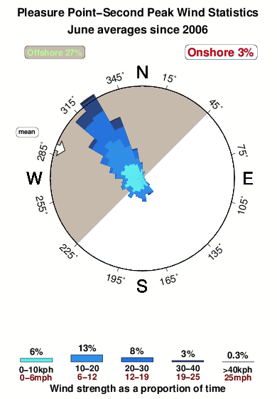
Pleasure Point-Second Peak in Santa Cruz is a reasonably exposed reef break that does not work very often with no particular seasonal pattern. Offshore winds blow from the northwest. Groundswells more frequent than windswells and the best swell direction is from the southwest. There is a right hand reef break. Best around low tide. Often Crowded. Take care of sharks ,rocks and rips.
Pleasure Point-Second Peak Spot Info
| Type: | Rating: | Reliability: | Todays Sea Temp*: |
|---|---|---|---|
| inconsistent | 12.9°C*ocean temperature recorded from satellite |
Surfing Pleasure Point-Second Peak:
The best conditions reported for surf at Pleasure Point-Second Peak occur when a South-southwest swell combines with an offshore wind direction from the Northwest.
What's the best time of year to surf Pleasure Point-Second Peak (for consistent clean waves)?
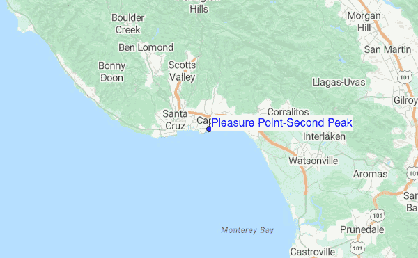
Explore Pleasure Point-Second Peak Location Map
Interactive Pleasure Point-Second Peak surf break location map. View information about nearby surf breaks, their wave consistency and rating compared to other spots in the region. Current swell conditions from local buoys are shown along with live wind speed and direction from nearby weather stations. Click icons on the map for more detail. The closest passenger airport to Pleasure Point-Second Peak is Norman Y Mineta San Jose International Airport (SJC) in USA, 45 km (28 miles) away (directly). The second nearest airport to Pleasure Point-Second Peak is Moffett Federal Afld (Mountain View) Airport (NUQ), also in USA, 51 km (32 miles) away.
- Map Icons:
 Break
Break Live Wave Height (m)
 Live Wind Speed (km/h)
 Surf Rating (10 Max)
 Ocean Swells (m)
- Wind Speed (km/h)
Tuesday, 9 June 2026, 16:07 Local Time
| Tuesday 09 | ||||
| 2PM | 5PM | 8PM | 11PM | |
| Wave (m) | ||||
| Period (s) | 19 | 19 | 19 | 18 |
| Wind (km/h) | ||||
| Wind State | cross- off |
off | glass | glass |
Tides at Pleasure Point-Second Peak
| NEXT | IS AT (local time) | remaining |
|---|---|---|
| high tide | ||
| low tide |
Pleasure Point-Second Peak Sea Temperature
Sunny with deceptively warm air temperatures, yet the sea remains quite cold at Pleasure Point-Second Peak. Surfers will need a good quality spring wetsuit and optionally a hood, neoprene gloves and boots.

Swell History at Pleasure Point-Second Peak
Surf stats for Pleasure Point-Second Peak, see the swell variation by month or season on the history page here.

Wind History at Pleasure Point-Second Peak
Wind stats for Pleasure Point-Second Peak, see the variation in direction and stength by month or season on the history page here.
Other Nearby Breaks Closest To:
Discover surf breaks near Pleasure Point-Second Peak. Click below to view there surf guides.
- Pleasure Point-First Peak
 Reef
Reef 3.0
3.0
Reliability: fairly consistent0km away - Pleasure Point-Insides
- Reef
- 3.0
Reliability: fairly consistent0km away - 41st Ave (The Hook - Shark Cove)
 Reef
Reef 2.0
2.0
Reliability: fairly consistent0km away - Beer Can Beach
 Beach
Beach- 3.0
Reliability: fairly consistent1km away - Capitola Jetty
- Reef
- 2.0
Reliability: inconsistent1km away
 Nearest