

Pease Bay Surf Guide
Pease Bay on the East Coast is a fairly exposed beach break that has consistent surf. Winter and spring are the optimum times of year to visit. Offshore winds blow from the southwest. Tends to receive a mix of groundswells and windswells and the ideal swell direction is from the northeast. The beach breaks offer lefts and rights. Good surf at all stages of the tide. Sometimes crowded. Beware of rocks / crowds.
Pease Bay Spot Info
| Type: | Rating: | Reliability: | Todays Sea Temp*: |
|---|---|---|---|
| consistent | 12.1°C*ocean temperature recorded from satellite |
Surfing Pease Bay:
The best conditions reported for surf at Pease Bay occur when a Northeast swell combines with an offshore wind direction from the Southwest.
What's the best time of year to surf Pease Bay (for consistent clean waves)?
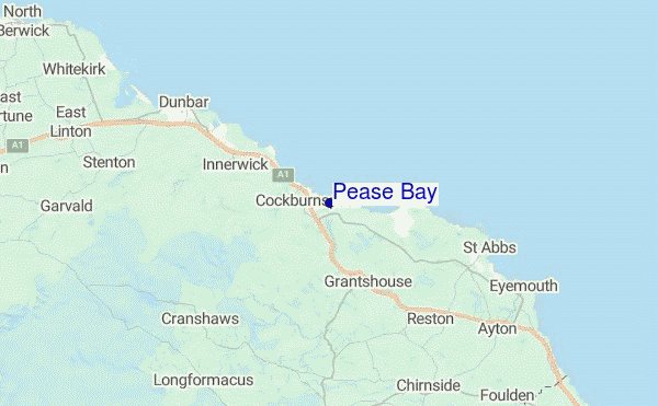
Explore Pease Bay Location Map
Interactive Pease Bay surf break location map. View information about nearby surf breaks, their wave consistency and rating compared to other spots in the region. Current swell conditions from local buoys are shown along with live wind speed and direction from nearby weather stations. Click icons on the map for more detail. The closest passenger airport to Pease Bay is Leuchars Airport (ADX) in U.k, 51 km (32 miles) away (directly). The second nearest airport to Pease Bay is Edinburgh Airport (EDI), also in U.k, 58 km (36 miles) away.
- Map Icons:
 Break
Break Live Wave Height (m)
 Live Wind Speed (km/h)
 Surf Rating (10 Max)
 Ocean Swells (m)
- Wind Speed (km/h)
Tuesday, 9 June 2026, 12:07 Local Time
| Tuesday 09 | ||||
| 10AM | 1PM | 4PM | 7PM | |
| Wave (m) | ||||
| Period (s) | 9 | 9 | 9 | 8 |
| Wind (km/h) | ||||
| Wind State | cross- off |
cross- off |
cross- off |
cross- off |
Tides at Pease Bay
| NEXT | IS AT (local time) | remaining |
|---|---|---|
| high tide | ||
| low tide |
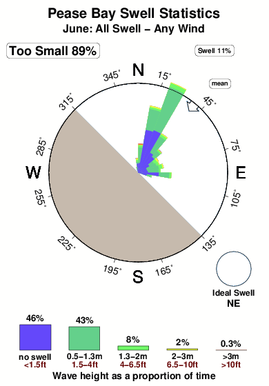
Swell History at Pease Bay
Surf stats for Pease Bay, see the swell variation by month or season on the history page here.

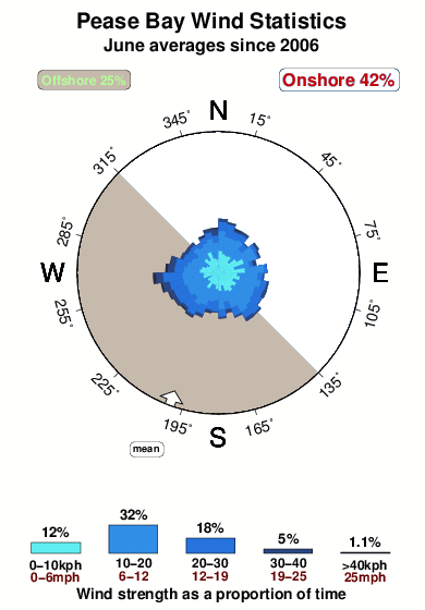
Wind History at Pease Bay
Wind stats for Pease Bay, see the variation in direction and stength by month or season on the history page here.
Pease Bay Reviews:
Interactive Porthcawl Point location map. View nearby buoy information, live wind conditions and surrounding roads, paths and locations to help find new breaks. Click the buoys or wind icon to view more information.
- Overall:
 4.0
4.0 - Quality on a good day:4.0
- Consistency of Surf:3.5
- Difficulty Level:
 2.8
2.8 - Wind and Kite Surfing:
 1.0
1.0 - Crowds:2.5
Other Nearby Breaks Closest To:
Discover surf breaks near Pease Bay. Click below to view there surf guides.
- Chapel Point
 Point
Point- 4.0
Reliability: fairly consistent10km away - Coldingham Bay
 Beach
Beach- 3.0
Reliability: fairly consistent14km away - White Sands
 Reef
Reef- 3.0
Reliability: fairly consistent14km away - Dunbar/Belhaven Bay
- Beach and reef
 2.0
2.0
Reliability: very consistent15km away - Eyemouth
- Beach
- 2.0
Reliability: fairly consistent16km away
 Nearest