

Old Kona Airport State Park Surf Guide
Old Kona Airport State Park in Big Island is a reasonably exposed beach and reef break that is usually a safe bet and works all around the year. The best wind direction is from the east. Tends to receive distant groundswells and the ideal swell direction is from the west northwest. Waves at the beach are both lefts and rights. Best around high tide. Sometimes crowded. Hazards include urchins, rips, rocks and locals.
Old Kona Airport State Park Spot Info
| Type: | Rating: | Reliability: | Todays Sea Temp*: |
|---|---|---|---|
| very consistent | 26.4°C*ocean temperature recorded from satellite |
Surfing Old Kona Airport State Park:
The best conditions reported for surf at Old Kona Airport State Park occur when a West-northwest swell combines with an offshore wind direction from the East.
What's the best time of year to surf Old Kona Airport State Park (for consistent clean waves)?
Explore Old Kona Airport State Park Location Map
Interactive Old Kona Airport State Park surf break location map. View information about nearby surf breaks, their wave consistency and rating compared to other spots in the region. Current swell conditions from local buoys are shown along with live wind speed and direction from nearby weather stations. Click icons on the map for more detail. The closest passenger airport to Old Kona Airport State Park is Kona International At Keahole Airport (KOA) in Usa Hawaii Isl., 10 km (6 miles) away (directly). The second nearest airport to Old Kona Airport State Park is Bradshaw Aaf Airport (BSF), also in Usa Hawaii Isl., 52 km (32 miles) away.
- Map Icons:
 Break
Break Live Wave Height (m)
 Live Wind Speed (km/h)
 Surf Rating (10 Max)
 Ocean Swells (m)
- Wind Speed (km/h)
Monday, 8 June 2026, 18:16 Local Time
| Monday 08 | Tue | |||
| 5PM | 8PM | 11PM | 2AM | |
| Wave (m) | ||||
| Period (s) | 7 | 6 | 7 | 6 |
| Wind (km/h) | ||||
| Wind State | on | on | glass | cross- off |
Tides at Old Kona Airport State Park
| NEXT | IS AT (local time) | remaining |
|---|---|---|
| high tide | ||
| low tide |
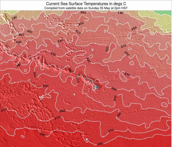
Old Kona Airport State Park Sea Temperature
Sunny with very warm air temperatures, feeling like 26.0 °C once we account for any wind. Sea temperatures (26.4 °C) very warm too. Staying comfortable in the water at Old Kona Airport State Park won't be a problem, but wear at least a rash-vest to keep the UV off.
Swell History at Old Kona Airport State Park
Surf stats for Old Kona Airport State Park, see the swell variation by month or season on the history page here.

Wind History at Old Kona Airport State Park
Wind stats for Old Kona Airport State Park, see the variation in direction and stength by month or season on the history page here.
Other Nearby Breaks Closest To:
Discover surf breaks near Old Kona Airport State Park. Click below to view there surf guides.
 Nearest