

- Forecast
- Maps
- Live
- Weather State
- Spot Information
Mntafufu Surf Forecast
/ Eastern Cape – Wild Coast (51 surf breaks) /
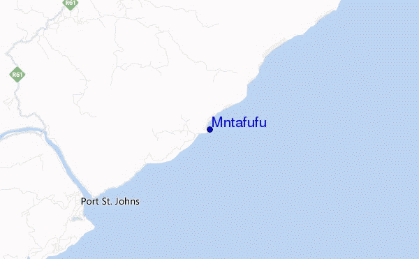
Mntafufu surf Forecast / Eastern Cape – Wild Coast / South Africa
- Map Icons:
 Break
Break Live Wave Height (m)
 Live Wind Speed (km/h)
 Surf Rating (10 Max)
 Ocean Swells (m)
- Wind Speed (km/h)
How big are the waves at Mntafufu today?
The current surf forecast for Mntafufu at 12PM is: 2.1m 16s primary swell from a South-southwest direction and 0.7m 7s secondary swell from a East direction, 0.8m 4s secondary swell from a Northeast direction (forecast issued at 07:00am April 24). The wind direction is predicted to be cross-onshore and the swell rating is 3.
| Time (SAST) & Date | Wave Height | Wave Period |
|---|---|---|
| Morning (24 Apr) | 7.5ft (2.3m) | 16s |
| Afternoon (24 Apr) | 6.5ft (2.0m) | 15s |
| Evening (24 Apr) | 5.5ft (1.7m) | 14s |
Table - waves today at Mntafufu. (Swell directed towards the surf break)
Wednesday 24 | Thursday 25 | Friday 26 | Saturday 27 | Sunday 28 | Monday 29 | Tuesday 30 | Wednesday 01 | |||||||||||||||||||||||||||||||||||||||||||||||||||||
| 5 AM | 8 AM | 11 AM | 2 PM | 5 PM | 8 PM | 11 PM | 2 AM | 5 AM | 8 AM | 11 AM | 2 PM | 5 PM | 8 PM | 11 PM | 2 AM | 5 AM | 8 AM | 11 AM | 2 PM | 5 PM | 8 PM | 11 PM | 2 AM | 5 AM | 8 AM | 11 AM | 2 PM | 5 PM | 8 PM | 11 PM | 2 AM | 5 AM | 8 AM | 11 AM | 2 PM | 5 PM | 8 PM | 11 PM | 2 AM | 5 AM | 8 AM | 11 AM | 2 PM | 5 PM | 8 PM | 11 PM | 2 AM | 5 AM | 8 AM | 11 AM | 2 PM | 5 PM | 8 PM | 11 PM | 2 AM | 5 AM | 8 AM | 11 AM | 2 PM | |
Rating (10 max) | ||||||||||||||||||||||||||||||||||||||||||||||||||||||||||||
Swell Height Map |    |    |    |    |  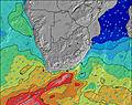 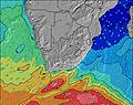 | 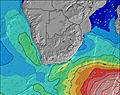 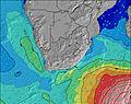 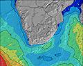 | 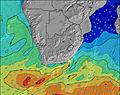 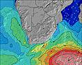 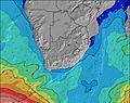 |    | ||||||||||||||||||||||||||||||||||||||||||||||||||||
| Wave Height (m) & direction (?) | ||||||||||||||||||||||||||||||||||||||||||||||||||||||||||||
| Period(s) (?) | 16 | 16 | 16 | 15 | 15 | 15 | 14 | 14 | 14 | 13 | 13 | 13 | 13 | 13 | 12 | 12 | 12 | 12 | 12 | 11 | 11 | 11 | 6 | 7 | 8 | 8 | 8 | 8 | 8 | 8 | 18 | 17 | 16 | 16 | 15 | 15 | 7 | 7 | 7 | 7 | 8 | 16 | 16 | 15 | 15 | 14 | 14 | 14 | 19 | 18 | 17 | 16 | 16 | 16 | 15 | 14 | 14 | 12 | 12 | 12 |
Wave (?)Graph | ||||||||||||||||||||||||||||||||||||||||||||||||||||||||||||
| Energy (?) | 2587 | 2523 | 2252 | 1795 | 1499 | 1275 | 1121 | 1091 | 900 | 722 | 700 | 608 | 599 | 483 | 365 | 359 | 294 | 236 | 174 | 163 | 154 | 116 | 153 | 255 | 111 | 259 | 301 | 270 | 235 | 254 | 316 | 351 | 326 | 322 | 291 | 191 | 192 | 332 | 228 | 568 | 480 | 318 | 387 | 434 | 405 | 400 | 366 | 293 | 340 | 515 | 487 | 438 | 330 | 310 | 292 | 327 | 304 | 260 | 244 | 240 |
Wind (km/h) | ||||||||||||||||||||||||||||||||||||||||||||||||||||||||||||
| Wind State (?) onshore cross-onshore cross-shore cross-offshore offshore glassy | cross | cross | cross- on | cross- on | cross- on | cross | cross- off | cross- off | off | off | cross- off | cross- off | cross- off | cross- off | cross- off | cross- off | cross- off | cross- off | cross- off | cross- off | cross | cross | cross | cross- on | cross- on | on | on | cross- on | cross- on | cross- on | cross- on | cross- on | cross- on | cross- on | cross- on | cross- on | cross- on | cross | cross- on | cross- on | cross- off | cross | glass | cross- on | cross- on | glass | glass | off | off | off | cross | cross- on | glass | cross | cross | cross | cross | cross | cross | cross- on |
High Tide / height (m) | 3:50AM 1.71 | 4:05PM 1.59 | 4:15AM 1.71 | 4:31PM 1.58 | 4:42AM 1.67 | 4:59PM 1.54 | 5:10AM 1.60 | 5:29PM 1.46 | 5:41AM 1.51 | 6:04PM 1.37 | 6:18AM 1.39 | 6:49PM 1.26 | 7:08AM 1.25 | 8:00PM 1.15 | 8:32AM 1.13 | |||||||||||||||||||||||||||||||||||||||||||||
Low Tide / height (m) | 10:00AM 0.07 | 10:04PM 0.10 | 10:26AM 0.08 | 10:31PM 0.13 | 10:53AM 0.11 | 10:59PM 0.18 | 11:23AM 0.18 | 11:30PM 0.26 | 11:56AM 0.27 | 12:06AM 0.37 | 12:37PM 0.38 | 12:53AM 0.50 | 1:35PM 0.50 | 2:11AM 0.63 | ||||||||||||||||||||||||||||||||||||||||||||||
Wednesday 24 | Thursday 25 | Friday 26 | Saturday 27 | Sunday 28 | Monday 29 | Tuesday 30 | Wednesday 01 | |||||||||||||||||||||||||||||||||||||||||||||||||||||
| Sunrise | - | 6:28 | - | - | - | - | - | - | - | 6:28 | - | - | - | - | - | - | - | 6:28 | - | - | - | - | - | - | - | 6:30 | - | - | - | - | - | - | - | 6:31 | - | - | - | - | - | - | - | 6:31 | - | - | - | - | - | - | - | 6:31 | - | - | - | - | - | - | - | 6:33 | - | - |
| Sunset | - | - | - | - | 5:30 | - | - | - | - | - | - | - | 5:29 | - | - | - | - | - | - | - | 5:28 | - | - | - | - | - | - | - | 5:27 | - | - | - | - | - | - | - | 5:25 | - | - | - | - | - | - | - | 5:24 | - | - | - | - | - | - | - | 5:23 | - | - | - | - | - | - | - |
Rain (mm) | - | - | - | - | - | - | - | - | - | - | - | - | - | 1 | 2 | 1 | - | - | - | - | 3 | 2 | 1 | - | - | - | - | - | - | - | - | - | - | - | - | - | - | 1 | 1 | - | - | - | - | - | - | - | - | - | - | - | - | - | - | - | - | - | - | - | - | - |
| Temp. °C | 21 | 21 | 24 | 25 | 23 | 22 | 21 | 21 | 20 | 21 | 24 | 24 | 22 | 21 | 21 | 20 | 20 | 20 | 22 | 21 | 21 | 20 | 20 | 20 | 19 | 19 | 20 | 20 | 20 | 19 | 19 | 18 | 18 | 18 | 21 | 22 | 21 | 19 | 19 | 20 | 19 | 20 | 25 | 25 | 23 | 22 | 21 | 20 | 20 | 21 | 24 | 24 | 23 | 21 | 20 | 20 | 20 | 21 | 28 | 30 |
| Feels °C (?) | 22 | 22 | 24 | 26 | 24 | 25 | 23 | 21 | 20 | 22 | 24 | 23 | 22 | 22 | 21 | 19 | 19 | 18 | 19 | 19 | 20 | 18 | 19 | 19 | 19 | 19 | 19 | 18 | 17 | 16 | 16 | 15 | 13 | 14 | 19 | 20 | 18 | 19 | 18 | 19 | 20 | 21 | 27 | 26 | 24 | 24 | 23 | 20 | 21 | 22 | 25 | 26 | 26 | 23 | 22 | 21 | 20 | 20 | 27 | 29 |
FREE! Surf-Forecast.com widget for your website
The surf report / weather widget below is available to embed on third party websites free of charge and provides a summary of our Mntafufu surf forecast. Simply grab the html code snippet that we provide and paste it into your own site. You can choose your preferred language and metric/imperial units for the surf forecast feed to suit users of your site. Click here to get the code.


 Nearest