

Misquamicut State Beach Surf Guide
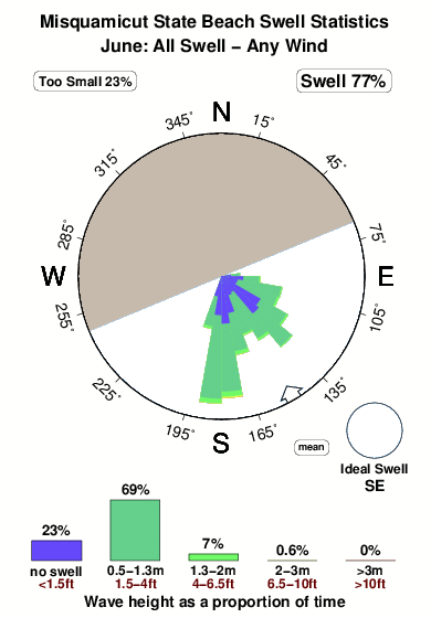
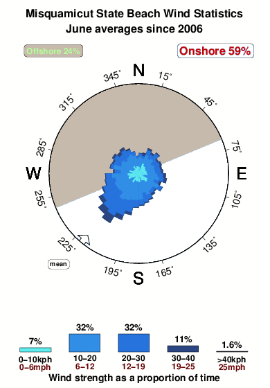
Misquamicut State Beach in Rhode Island is a fairly exposed beach break that is often working and works all around the year. Offshore winds blow from the north northwest. Most of the surf here comes from groundswells and the ideal swell direction is from the southeast. Good surf at all stages of the tide. When the surf is up, crowds are likely
Misquamicut State Beach Spot Info
| Type: | Rating: | Reliability: | Todays Sea Temp*: |
|---|---|---|---|
| very consistent | 14.1°C*ocean temperature recorded from satellite |
Surfing Misquamicut State Beach:
The best conditions reported for surf at Misquamicut State Beach occur when a Southeast swell combines with an offshore wind direction from the North-northwest.
What's the best time of year to surf Misquamicut State Beach (for consistent clean waves)?
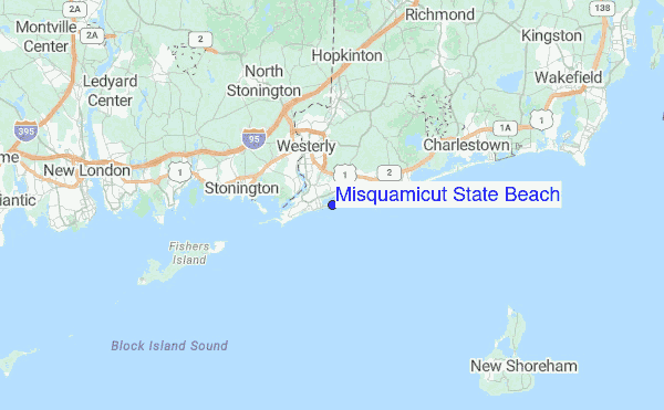
Explore Misquamicut State Beach Location Map
Interactive Misquamicut State Beach surf break location map. View information about nearby surf breaks, their wave consistency and rating compared to other spots in the region. Current swell conditions from local buoys are shown along with live wind speed and direction from nearby weather stations. Click icons on the map for more detail. The closest passenger airport to Misquamicut State Beach is Theodore Francis Green State (Providence) Airport (PVD) in USA, 54 km (34 miles) away (directly). The second nearest airport to Misquamicut State Beach is North Central State (Smithfield) Airport (SFZ), also in USA, 71 km (44 miles) away.
- Map Icons:
 Break
Break Live Wave Height (m)
 Live Wind Speed (km/h)
 Surf Rating (10 Max)
 Ocean Swells (m)
- Wind Speed (km/h)
Tuesday, 9 June 2026, 06:01 Local Time
| Tuesday 09 | ||||
| 5AM | 8AM | 11AM | 2PM | |
| Wave (m) | ||||
| Period (s) | 6 | 6 | 6 | 4 |
| Wind (km/h) | ||||
| Wind State | cross | cross- off |
cross | cross- on |
Tides at Misquamicut State Beach
| NEXT | IS AT (local time) | remaining |
|---|---|---|
| high tide | ||
| low tide |
Swell History at Misquamicut State Beach
Surf stats for Misquamicut State Beach, see the swell variation by month or season on the history page here.

Wind History at Misquamicut State Beach
Wind stats for Misquamicut State Beach, see the variation in direction and stength by month or season on the history page here.
Misquamicut State Beach Reviews:
Interactive Porthcawl Point location map. View nearby buoy information, live wind conditions and surrounding roads, paths and locations to help find new breaks. Click the buoys or wind icon to view more information.
- Overall:
 3.0
3.0 - Quality on a good day:
 4.0
4.0 - Consistency of Surf:
 4.8
4.8 - Difficulty Level:3.2
- Wind and Kite Surfing:3.0
- Crowds:3.2
Water temperature OK in August if a normally very warm Summer.
Never crowded Monday - Friday. Friendly beach manager and always a lifeguard through Labor Day.
Never heard anyone mention rip tides under normal circumstances.
Opposite the State beach next to the State of R.I. Fishing parking lot.”
Other Nearby Breaks Closest To:
Discover surf breaks near Misquamicut State Beach. Click below to view there surf guides.
- Fenway Beach
 Breakwater
Reliability: fairly consistent3km away - Panic Point (Weekapaug)
 Point
Point
Reliability: inconsistent4km away - East Beach Lighthouse
 Point
Point 2.0
2.0
Reliability: inconsistent5km away - Napatree Jetty
- Breakwater
- 2.0
Reliability: fairly consistent6km away - Breachway
- Beach/jetty
- 2.0
Reliability: fairly consistent7km away
 Nearest