

- Forecast
- Maps
- Live
- Weather State
- Spot Information
Marengo Surf Forecast
/ VIC – Cape Otway (10 breaks) / Victoria (127 breaks) /
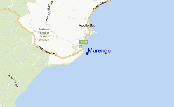
Marengo surf Forecast / VIC – Cape Otway / Australia
- Map Icons:
 Break
Break Live Wave Height (m)
 Live Wind Speed (km/h)
 Surf Rating (10 Max)
 Ocean Swells (m)
- Wind Speed (km/h)
How big are the waves at Marengo today?
The current surf forecast for Marengo at 6PM is: 2.4m 14s primary swell from a South-southwest direction and 0.8m 6s secondary swell from a Southeast direction, 0.7m 6s secondary swell from a East-southeast direction (forecast issued at 03:00pm April 19). The wind direction is predicted to be cross-shore and the swell rating is 4.
| Time (AEST) & Date | Wave Height | Wave Period |
|---|---|---|
| Morning (19 Apr) | - | - |
| Afternoon (19 Apr) | 8ft (2.5m) | 14s |
| Evening (19 Apr) | 7ft (2.1m) | 14s |
Table - waves today at Marengo. (Swell directed towards the surf break)
Friday 19 | Saturday 20 | Sunday 21 | Monday 22 | Tuesday 23 | Wednesday 24 | Thursday 25 | Friday 26 | |||||||||||||||||||||||||||||||||||||||||||||||||||||
| 1 PM | 4 PM | 7 PM | 10 PM | 1 AM | 4 AM | 7 AM | 10 AM | 1 PM | 4 PM | 7 PM | 10 PM | 1 AM | 4 AM | 7 AM | 10 AM | 1 PM | 4 PM | 7 PM | 10 PM | 1 AM | 4 AM | 7 AM | 10 AM | 1 PM | 4 PM | 7 PM | 10 PM | 1 AM | 4 AM | 7 AM | 10 AM | 1 PM | 4 PM | 7 PM | 10 PM | 1 AM | 4 AM | 7 AM | 10 AM | 1 PM | 4 PM | 7 PM | 10 PM | 1 AM | 4 AM | 7 AM | 10 AM | 1 PM | 4 PM | 7 PM | 10 PM | 1 AM | 4 AM | 7 AM | 10 AM | 1 PM | 4 PM | 7 PM | 10 PM | |
Rating (10 max) | ||||||||||||||||||||||||||||||||||||||||||||||||||||||||||||
Swell Height Map |    |    |    |   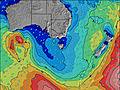 | 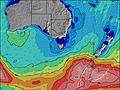 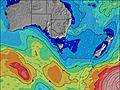 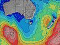 | 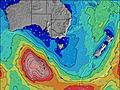 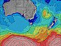 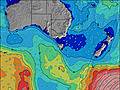 | 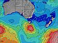 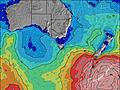 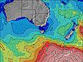 | 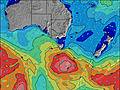 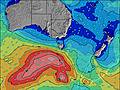 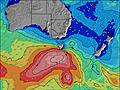 | ||||||||||||||||||||||||||||||||||||||||||||||||||||
| Wave Height (m) & direction (?) | ||||||||||||||||||||||||||||||||||||||||||||||||||||||||||||
| Period(s) (?) | 13 | 14 | 14 | 14 | 14 | 14 | 14 | 14 | 13 | 13 | 13 | 13 | 13 | 13 | 13 | 13 | 13 | 13 | 13 | 13 | 17 | 16 | 16 | 15 | 14 | 14 | 14 | 14 | 14 | 13 | 13 | 13 | 19 | 18 | 16 | 16 | 16 | 15 | 14 | 12 | 11 | 11 | 14 | 14 | 13 | 9 | 13 | 13 | 13 | 13 | 12 | 16 | 15 | 15 | 15 | 14 | 14 | 14 | 14 | 14 |
Wave (?)Graph | ||||||||||||||||||||||||||||||||||||||||||||||||||||||||||||
| Energy (?) | 2279 | 2118 | 2079 | 1710 | 1516 | 1408 | 1193 | 1005 | 808 | 529 | 623 | 494 | 424 | 376 | 370 | 373 | 414 | 451 | 451 | 479 | 1290 | 1144 | 1074 | 856 | 736 | 581 | 590 | 513 | 499 | 451 | 437 | 437 | 1016 | 1925 | 2241 | 2270 | 2185 | 5477 | 9350 | 6370 | 2274 | 1703 | 5417 | 4708 | 4464 | 585 | 2914 | 2752 | 2822 | 2590 | 2549 | 3102 | 3241 | 3241 | 2701 | 2329 | 2122 | 1772 | 1579 | 1280 |
Wind (km/h) | ||||||||||||||||||||||||||||||||||||||||||||||||||||||||||||
| Wind State (?) onshore cross-onshore cross-shore cross-offshore offshore glassy | cross | cross | cross- on | cross- on | cross | cross | cross | cross | cross- off | cross- off | cross- off | cross- off | off | off | off | cross- off | cross- off | cross- off | cross- off | glass | cross- off | cross- off | cross- off | glass | cross- off | cross- off | glass | cross | cross- off | cross- off | cross- off | cross- off | glass | on | cross- on | cross | cross- off | cross- off | cross- off | cross- off | cross- off | off | off | off | off | off | cross- off | cross- off | cross- off | cross- off | cross- off | cross- off | cross | cross- off | cross- off | cross- off | cross- off | cross- off | cross- off | cross |
High Tide / height (m) | 9:52PM 1.36 | 10:29AM 1.58 | 11:20PM 1.55 | 11:23AM 1.62 | 12:10AM 1.77 | 12:02PM 1.66 | 12:46AM 1.98 | 12:33PM 1.70 | 1:17AM 2.16 | 1:00PM 1.74 | 1:46AM 2.30 | 1:26PM 1.76 | 2:15AM 2.40 | 1:51PM 1.76 | ||||||||||||||||||||||||||||||||||||||||||||||
Low Tide / height (m) | 4:09PM 1.05 | 4:00AM 1.01 | 5:10PM 0.92 | 5:28AM 0.97 | 5:46PM 0.78 | 6:21AM 0.90 | 6:15PM 0.65 | 7:00AM 0.84 | 6:41PM 0.52 | 7:33AM 0.79 | 7:07PM 0.41 | 8:03AM 0.76 | 7:33PM 0.31 | 8:32AM 0.75 | 7:59PM 0.23 | |||||||||||||||||||||||||||||||||||||||||||||
Friday 19 | Saturday 20 | Sunday 21 | Monday 22 | Tuesday 23 | Wednesday 24 | Thursday 25 | Friday 26 | |||||||||||||||||||||||||||||||||||||||||||||||||||||
| Sunrise | - | - | - | - | - | - | 6:56 | - | - | - | - | - | - | - | 6:58 | - | - | - | - | - | - | - | 6:58 | - | - | - | - | - | - | - | - | 7:00 | - | - | - | - | - | - | - | 7:01 | - | - | - | - | - | - | - | 7:01 | - | - | - | - | - | - | - | 7:03 | - | - | - | - |
| Sunset | - | 5:51 | - | - | - | - | - | - | - | 5:50 | - | - | - | - | - | - | - | 5:47 | - | - | - | - | - | - | - | 5:46 | - | - | - | - | - | - | - | 5:45 | - | - | - | - | - | - | - | 5:44 | - | - | - | - | - | - | - | 5:43 | - | - | - | - | - | - | - | 5:42 | - | - |
Rain (mm) | - | - | - | - | - | - | - | - | - | - | - | - | - | - | - | - | - | - | - | - | - | - | - | - | - | - | - | - | - | - | - | - | - | - | - | - | 1 | 1 | 1 | 1 | 1 | 1 | - | - | 1 | 2 | - | - | - | - | - | - | - | - | - | - | - | - | - | - |
| Temp. °C | 16 | 15 | 13 | 13 | 12 | 11 | 12 | 13 | 13 | 13 | 11 | 10 | 10 | 9 | 9 | 12 | 14 | 14 | 11 | 10 | 10 | 9 | 9 | 14 | 17 | 17 | 13 | 13 | 14 | 13 | 12 | 17 | 20 | 20 | 18 | 20 | 13 | 12 | 14 | 14 | 12 | 13 | 13 | 13 | 13 | 13 | 12 | 12 | 12 | 12 | 12 | 12 | 12 | 12 | 12 | 12 | 13 | 13 | 12 | 12 |
| Feels °C (?) | 13 | 12 | 10 | 11 | 11 | 9 | 11 | 11 | 11 | 11 | 9 | 8 | 9 | 7 | 7 | 10 | 11 | 12 | 9 | 9 | 9 | 7 | 7 | 13 | 15 | 15 | 12 | 10 | 10 | 9 | 8 | 14 | 18 | 18 | 15 | 15 | 9 | 5 | 7 | 7 | 6 | 7 | 8 | 8 | 8 | 6 | 5 | 5 | 6 | 6 | 7 | 7 | 8 | 8 | 8 | 9 | 10 | 10 | 10 | 10 |
FREE! Surf-Forecast.com widget for your website
The surf report / weather widget below is available to embed on third party websites free of charge and provides a summary of our Marengo surf forecast. Simply grab the html code snippet that we provide and paste it into your own site. You can choose your preferred language and metric/imperial units for the surf forecast feed to suit users of your site. Click here to get the code.


 Nearest