

Lovers Point Surf Guide
Lovers Point in Monterey is a reasonably exposed point break that only works once in a while. Winter is the best time of year for surfing here. Offshore winds blow from the south. Groundswells are more common than windswells and the best swell direction is from the northwest.There is a left hand point break here. Even when there are waves, it's not likley to be crowded. Beware of rips and rocks.
Lovers Point Spot Info
| Type: | Rating: | Reliability: | Todays Sea Temp*: |
|---|---|---|---|
| inconsistent | 11.9°C*ocean temperature recorded from satellite |
Surfing Lovers Point:
The best conditions reported for surf at Lovers Point occur when a Northwest swell combines with an offshore wind direction from the South.
What's the best time of year to surf Lovers Point (for consistent clean waves)?
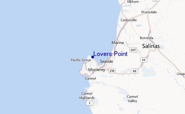
Explore Lovers Point Location Map
Interactive Lovers Point surf break location map. View information about nearby surf breaks, their wave consistency and rating compared to other spots in the region. Current swell conditions from local buoys are shown along with live wind speed and direction from nearby weather stations. Click icons on the map for more detail. The closest passenger airport to Lovers Point is Norman Y Mineta San Jose International Airport (SJC) in USA, 81 km (50 miles) away (directly). The second nearest airport to Lovers Point is Moffett Federal Afld (Mountain View) Airport (NUQ), also in USA, 88 km (55 miles) away.
- Map Icons:
 Break
Break Live Wave Height (m)
 Live Wind Speed (km/h)
 Surf Rating (10 Max)
 Ocean Swells (m)
- Wind Speed (km/h)
Tuesday, 9 June 2026, 08:40 Local Time
| Tuesday 09 | ||||
| 8AM | 11AM | 2PM | 5PM | |
| Wave (m) | ||||
| Period (s) | 7 | 9 | 9 | 10 |
| Wind (km/h) | ||||
| Wind State | on | cross- on |
cross- on |
cross- on |
Tides at Lovers Point
| NEXT | IS AT (local time) | remaining |
|---|---|---|
| high tide | ||
| low tide |

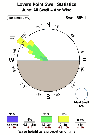
Swell History at Lovers Point
Surf stats for Lovers Point, see the swell variation by month or season on the history page here.

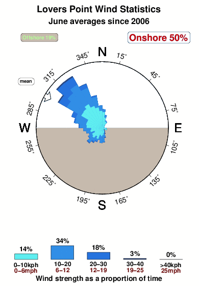
Wind History at Lovers Point
Wind stats for Lovers Point, see the variation in direction and stength by month or season on the history page here.
Other Nearby Breaks Closest To:
Discover surf breaks near Lovers Point. Click below to view there surf guides.
- Asilomar
 Beach and reef
 2.0
2.0
Reliability: consistent2km away - Spanish Bay-Cobblestones
- Beach
- 2.0
Reliability: fairly consistent3km away - Spanish Bay-Dunes
- Beach and reef
- 2.0
Reliability: consistent3km away - Spanish Bay-South Moss
- Beach
- 2.0
Reliability: fairly consistent3km away - Del Monte Beach
 Sandbar
- 2.0
Reliability: consistent4km away
 Nearest