

Lighthouse Beach Surf Guide
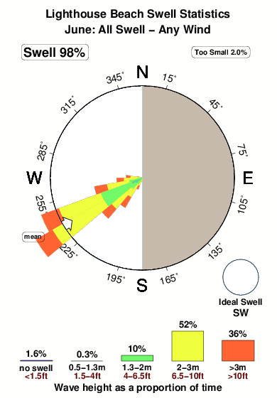
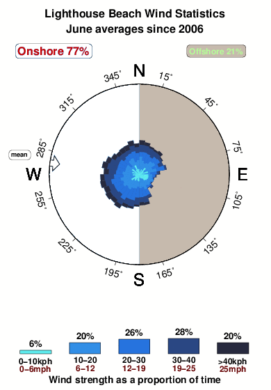
Lighthouse Beach on the West Coast is an exposed beach break that has fairly consistent surf, although summer tends to be mostly flat. The best wind direction is from the east with some shelter here from southwest winds. Groundswells more frequent than windswells and the best swell direction is from the southwest. Waves at the beach are mainly lefts. Surfable at all stages of the tide. It very rarely gets crowded here. Hazards include rips, rocks,kelp.
Lighthouse Beach Spot Info
| Type: | Rating: | Reliability: | Todays Sea Temp*: |
|---|---|---|---|
| fairly consistent | 15.4°C*ocean temperature recorded from satellite |
Surfing Lighthouse Beach:
The best conditions reported for surf at Lighthouse Beach occur when a Southwest swell combines with an offshore wind direction from the East.
What's the best time of year to surf Lighthouse Beach (for consistent clean waves)?
Explore Lighthouse Beach Location Map
Interactive Lighthouse Beach surf break location map. View information about nearby surf breaks, their wave consistency and rating compared to other spots in the region. Current swell conditions from local buoys are shown along with live wind speed and direction from nearby weather stations. Click icons on the map for more detail. The nearest passenger airport to Lighthouse Beach is Launceston Airport (LST) in Australia, which is 228 km (142 miles) away (directly). The second closest airport to Lighthouse Beach is Hobart Airport (HBA), also in Australia, 320 km (199 miles) away.
- Map Icons:
 Break
Break Live Wave Height (m)
 Live Wind Speed (km/h)
 Surf Rating (10 Max)
 Ocean Swells (m)
- Wind Speed (km/h)
Tuesday, 9 June 2026, 19:36 Local Time
| Tue | Wed | |||
| 7PM | 10PM | 1AM | 4AM | |
| Wave (m) | ||||
| Period (s) | 16 | 16 | 15 | 14 |
| Wind (km/h) | ||||
| Wind State | cross- off |
cross- off |
cross- off |
cross |
Tides at Lighthouse Beach
| NEXT | IS AT (local time) | remaining |
|---|---|---|
| high tide | ||
| low tide |
Swell History at Lighthouse Beach
Surf stats for Lighthouse Beach, see the swell variation by month or season on the history page here.


Wind History at Lighthouse Beach
Wind stats for Lighthouse Beach, see the variation in direction and stength by month or season on the history page here.
Other Nearby Breaks Closest To:
Discover surf breaks near Lighthouse Beach. Click below to view there surf guides.
- Nettley Bay Point
 Point
Point 3.0
3.0
Reliability: fairly consistent1km away - Nettley Bay Reefs
 Reef
Reef- 3.0
Reliability: fairly consistent1km away - Greens Point Beach
 Beach and point
- 3.0
Reliability: fairly consistent5km away - Mount Cameron
- Beach and reef
- 3.0
Reliability: inconsistent11km away - Church Bay
 River
River- 3.0
Reliability: consistent13km away
 Nearest